
Voröstó
| Voröstó | |||||
|
|||||
| Basic data | |||||
|---|---|---|---|---|---|
| State : | Hungary | ||||
| Region : | Central Transdanubia | ||||
| County : | Veszprém | ||||
| Small area until December 31, 2012 : | Veszprém | ||||
| District since 1.1.2013 : | Veszprém | ||||
| Coordinates : | 46 ° 58 ' N , 17 ° 43' E | ||||
| Area : | 6.19 km² | ||||
| Residents : | 102 (Jan. 1, 2011) | ||||
| Population density : | 16 inhabitants per km² | ||||
| Telephone code : | (+36) 88 | ||||
| Postal code : | 8291 | ||||
| KSH kódja: | 11703 | ||||
| Structure and administration (as of 2020) | |||||
| Community type : | local community | ||||
| Mayoress : | Gabriella Fekete-Tracz (independent) | ||||
| Postal address : | Fő utca 58 8291 Vöröstó |
||||
| Website : | |||||
| (Source: A Magyar Köztársaság helységnévkönyve 2011. január 1st at Központi statisztikai hivatal ) | |||||


Vöröstó is a Hungarian municipality in the Veszprém County in Veszprém County .
Geographical location
Vöröstó is located 20 kilometers southwest of the city of Veszprém and about 14 kilometers from the northern bank of Lake Balaton . Neighboring communities are Barnag, Nagyvázsony and Mencshely.
Infrastructure
In Vöröstó there is a mayor's office and the Roman Catholic Church, as well as a distillery that produces pálinka .
Attractions
- Village Museum ( Faluház )
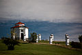
- Calvary with chapel, built in the first half of the 19th century, on the eastern edge of the village
- Roman Catholic Church Szeplőtelen Fogantatás , built 1825–1826 (late baroque)
- Szentháromság statue ( Szentháromság-szobor ), erected in 1912, in front of the church
- Traditional farmhouses from the 19th century
- World War Memorial ( I. és II. Világháborús emlékmű ), in front of the cemetery
traffic
The side road No. 73113 runs through Vöröstó. There is a minibus connection to Nagyvázsony. The nearest train station Balatonakali -Dörgicse is 14 kilometers south of Lake Balaton.
photos

Calvary with chapel

Stations on the Calvary
Chapel on the Calvary
_6.jpg)
_5.jpg)
.jpg)
Individual evidence
- ↑ Kiket választottak polgármesterré Veszprém megye települé sein? VEOL, October 15, 2019, accessed February 29, 2020 (Hungarian).
Web links
- Official website ( Hungarian )
- Vöröstó on tourinform (Hungarian)