
Administrative community perennials
| coat of arms | Germany map | |
|---|---|---|

|
Coordinates: 48 ° 15 ' N , 10 ° 36' E |
|
| Basic data | ||
| Existing period: | 1978– | |
| State : | Bavaria | |
| Administrative region : | Swabia | |
| County : | augsburg | |
| Area : | 74.11 km 2 | |
| Residents: | 6370 (Dec. 31, 2019) | |
| Population density : | 86 inhabitants per km 2 | |
| License plate : | A , SMÜ, WHO | |
| Association key : | 09 7 72 5709 | |
| Association structure: | 5 municipalities | |
| Association administration address : |
Rathausstrasse 58 86863 Langenneufnach |
|
| Website : | ||
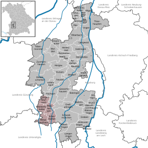
| Location of the administrative community of perennials in the Augsburg district | ||
  |
||

The administrative community of perennials (named after the hill country perennials ) in the Swabian district of Augsburg was created on May 1, 1978 by ordinance of the government of Swabia , when the municipalities
- Langenneufnach , 1766 inhabitants, 12.82 km²
- Mickhausen , 1438 inhabitants, 15.89 km²
- Mittelneufnach , 1027 inhabitants, 16.93 km²
- Scherstetten , 1047 inhabitants, 15.72 km²
- Walkertshofen , 1092 inhabitants, 12.75 km²
merged into an administrative community. It originally carried the name Verwaltungsgemeinschaft Langenneufnach .
The administrative community is based in Langenneufnach.
Individual evidence
- ↑ "Data 2" sheet, Statistical Report A1200C 202041 Population of the municipalities, districts and administrative districts 1st quarter 2020 (population based on the 2011 census) ( help ).
Administrative communities in the Augsburg district
Gessertshausen | Großaitingen | Langerringen | Lechfeld | Nordendorf | Perennials | Welden