
Via della Conciliazione

The Via della Conciliazione ( Italian for road reconciliation ) in Rome is a 1936 Mussolini planned and Pope Jubilee completed in 1950 about 500 m long road axis from Tiber in the direction St Peter leads and on the other hand via the Corso Vittorio Emanuele II , the Vatican with connects to the historical center of Rome.
history
Since the Renaissance there have been plans for a representative redesign of the entrance through the Borgo to St. Peter's Church. Pope Nicholas V had Leon Battista Alberti draw up a plan in which the entire quarter between Castel Sant'Angelo and the Vatican should be rearranged in a checkerboard pattern. After the Pope's death, this plan was not implemented. For the holy year 1500 Pope Alexander VI. only realize Via Alessandrina (later Borgo Nuovo), which was oriented towards the entrance of the Papal Palace. The Meta Romuli was demolished for their construction .
By Donato Bramante , who for Pope Julius II. Was planning the construction of St. Peter's, a sketch of a decorated with columns and obelisks road is obtained, which should be out of St Peter's, but was not realized. Neither was there a line of sight from the Angel's Bridge , which Domenico Fontana planned to put on the obelisk he set up on St. Peter's Square .
The planning of optical axes lapsed after Gian Lorenzo Bernini to St. Peter's Square with its colonnade, along the lines of the ancient forums , surrounded them. His principle was to play with the element of surprise when the pilgrims, coming from the winding Borgo, stepped through the colonnades and saw the wide square with the cathedral. This also worked, although the planned "third arm" of the colonnades was never realized.
Nevertheless, there were plans by various architects such as Giovanni Battista Nolli , Cosimo Morelli and Giuseppe Valadier , especially under Napoleon's reign , to organize or partially demolish the Borgo, but these were not realized. In 1852 Luigi Poletti gave the Borgo a representative entrance on the Tiber with two symmetrical buildings on Borgo Nuovo and Borgo Vecchio, as well as a fountain facade on the Spina.

.jpg)
With the end of the Papal States (1871) the planning sovereignty of the papacy ended. For the new capital of Italy, the regulatory plan of 1873 envisaged a network of new thoroughfares in the medieval city. Among them again the demolition of the Spina dei Borghi, the row of houses between the narrow streets of Borgo Vecchio and Borgo Nuovo leading to St. Peter's Basilica . After numerous protests by citizens, architects and historians, however, it was never carried out. Instead, the Palazzo dei Penitenzieri, with its frescoes by Pinturicchio , was placed under monument protection.
Only the fascist regime of Benito Mussolini was able to fall back on the radical proposed solutions. After clarifying the position of the papacy in the Lateran Treaties , new planning began. As early as 1929, the influential Italian architect and urban planner Marcello Piacentini had argued in two basic articles that in comparison to the “well-ordered” Paris, which “exhibited” its historical monuments, Rome was actually hiding its most beautiful and largest architectural monuments. A monument is seldom aligned with the axis of a straight road. Piacentini, also the creator of the EUR satellite town planned for the 1942 World Exhibition , named the difficult-to-find Piazza Navona as an example, as well as the unsatisfactory situation at St. Peter's Church. Piacentini's view was shared by Mussolini, who wanted access to “one of the greatest churches in Christendom”.
In amending the 1931 regulatory plan, it was decided not only to demolish the houses of the Spina, but also to demolish numerous adjacent historic buildings in the Borgo. The architects Piacentini and Spaccharelli were commissioned with the planning. The "Duce" himself hit the public for the first time with the pickaxe on October 28, 1936, and by October 1937 600,000 m³ of buildings had been torn away, including four churches and numerous historical palaces. After vehement protests, at least the Palazzo Torlonia (1496–1504), the Palazzo dei Penitenzieri and the Church of Santa Maria in Traspontina (1566–1637), which could be integrated into the new axis, were preserved. The Palazzo dei Convertendi (16th century) owned by the Vatican was demolished and rebuilt on the new street. But one of Rome's liveliest historical quarters was gone.
The newly created boulevard with its unified facades was named Via della Conciliazione according to the proposal of the journalist Franco Franchi - in memory of the Lateran Treaties of 1929, which brought a reconciliation between the Italian state and the papacy and the establishment of the modern Vatican state.
The Via della Conciliazione, like the Via dei Fori Imperiali, is an example of the continuing influence of Napoleon III's urban planning concepts . and his colleague Georges-Eugène Haussmann in Paris in the 20th century.
building
photos

View of the site around 1900

Via della Conciliazione
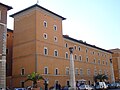
Palazzo Della Rovere (Seat of the Order of the Knights of the Holy Sepulcher in Jerusalem )

Via della Conciliazione with Castel Sant'Angelo in the background

People on the way to the laid out Pope John Paul II on April 4, 2005

At dawn


literature
- Antonio Cederna : Mussolini urbanista. Lo sventramento di Roma negli anni del consenso (= Voci sulla Città. ). Corte del Fontego, Venezia 2006, ISBN 88-95124-01-4 .
- Paolo Portoghesi : Roma, un'altra città. Eccezionali fotografie d'epoca rivelano immagini segrete di luoghi, monumenti e ambienti di una vita urbana sparita ( Quest'Italia. 17, ZDB -ID 433075-4 ). Newton Compton Editori, Roma 1981.
- Robert Schediwy : City Pictures. Reflections on the change in architecture and urbanism. 2nd Edition. Lit, Vienna 2005, ISBN 3-8258-7755-8 , especially pp. 204–206.
Web links
Coordinates: 41 ° 54 '8.4 " N , 12 ° 27' 39.6" E