
Vučji zub
| Vučji zub | ||
|---|---|---|
 The Vučji Zub from the Bijela gora from |
||
| height | 1802 m | |
| location | Montenegro / Bosnia-Herzegovina border | |
| Mountains | Orjen Mountains, Dinarides | |
| Coordinates | 42 ° 34 '52 " N , 18 ° 33' 13" E | |
|
||
| rock | lime | |
| Age of the rock | law | |
| First ascent | first presumed scientific ascent in 1865 by the Slovak botanist Jozef Pantocsek | |
| Normal way | about the Bijela gora | |

The Vučji zub ( Serbian : wolf tooth ) is a 1802 m high, steep karst mountain in the sub-Adriatic Dinarides in the Orjen Mountains in Montenegro . The Karling is geomorphologically formed as a horn . The Glaziokarst relief of Vučji zub is one of the traces of very intense glaciation. At 1802 m, it is a main peak of Orjen, which allows impressive views of the surrounding peaks of Zubački kabao and Velika Jastrebica . For centuries a border summit ("Triplex confinium") between the possessions of Venice and the Imperial and Royal Monarchy as well as the Ottoman Empire and Montenegro, it can be found in early cartographic works since the 17th century. In the second half of the 19th century, during the final phase of the uprising in Krivošije in 1882, fierce battles between troops of the Austro-Hungarian monarchy and the Montenegrin rebels took place at the summit of Vučji zub . The Imperial and Royal Monarchy maintained a permanent post at Vučji zub until World War I.

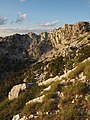
Location and relief
In Vučji zub, three important ridges knot in Orjen: from the west comes the Jastrebica ridge, from the east the Pazua or Reovačka greda ridge and to the north the Prasa ridge connects to the highest Orjen peak, the Zubački kabao . In this position the Vučji zub was for a long time a border point between three geographical regions: Dalmatia, Herzegovina and Montenegro. Politically, it formed a well-known triangle and was always shown on historical maps since the 18th and 19th centuries as one of only 4 - 5 peaks of the Orjen. The Vučji zub is neither clearly visible from the Bay of Kotor nor from the north side in old Montenegro. It is covered by the Jastrebica, the Zubački kabao and the Reovačka greda. Its striking shape is only visible over the Reovačka greda valley, the Dobri do valley or directly over the Katuništa. According to Phil Hughes, the summit was a nunatak at the time of the strongest glaciation of the mountains in the middle Pleistocene - MIS 12. Above the Vučji zub, the greatest ice thickness of 350 m has been reconstructed during this glaciation. It is designed as a distinctive karling in the shape of a horn. With its geomorphological features and ice formation, the summit is a good example of landscape forms in the Glaziokarst. In addition to layered stairs and glacial troughs, which often flow into Jamen at their lowest points, deep gully carts are also strikingly designed.

geology


Massive Cretaceous limestones dominate the uniform geological structure of Vučji zub. They dip at an angle of about 45 degrees to the north. Like the whole mountain range, they belong to the geological blanket of the Hochkarst. The north side is characterized by layered stairs. This design can be seen as a prime example of the Glazikarst, comparable to the Gottesacker plateau on Hohen Ifen in the Allgäu Alps. The layered stairs at Vučji zub are even more striking, grooved and mega carts cover the entire northern area from the apron to the summit. A variety of jams are formed between the individual shift packages.
The best known is the Vučji zub ice cave (actually a karst vent) described by Đuro Pany in 1930 . At the end of September 1929, Pany found large remains of snow in front of the entrance. The 20 m wide and 10 m high opening of the ice cave had an 8 m high ice pyramid inside. At that time, Pany was unable to further investigate the extent of the chimney or its other properties.
Since the massif itself was massively frozen in the middle Pleistocene, Quaternary sediments were deposited in the run-up to the summit. Younger Quaternary sediments have been deposited in the smaller uppermost karen on the NW, NE and SW sides. The larger cirques of the summit are in the trough valley of Dobri do and on the Bijela-gora side.
vegetation

The summit rises 300 m above the tree line. The tree line to just below the summit forms the snake skin pine . The summit is covered with high mountain Dinaric grass from the class of Elyno-Seslerietea alpine grass. These belong to the association Oxytropidion dinaricae in which Sesleria juncifolia and Carex kitaibeliana predominate. The two endemic cluster bells Edraianthus serpyllifolius and Edraianthus graminifolius are particularly striking . In addition, Thymus striatus , Dianthus sylvestris ssp. tergestinus , Potentilla speciosa , Gentiana utriculosa , Scabiosa silenifolia , the Neumayer jug fruit ( Amphoricarpos neumayerianus ) and the Dinaric pointed keel ( Oxytropis dinarica ) as a characteristic species of southeast Dinaric alpine limestone grasslands . Just below the summit is one of the three known locations of the endemic Orjen Iris . It was not until 2007 that Christian Bräuchler and Pavle Cikovac described it again. The Orjen Iris is a protected plant because it is limited to a few sites in the Orjen. It grows here in more protected hollows or at the foot of walls in which the more wind-sensitive Sesleria robusta also thrives. In the plant-sociological classification, the iris stocks are classified as Seslerion robustae . In addition to the locally endemic Orjen iris, the Bosnian iris ( Iris reichbachii ) also occurs frequently in the same location in slightly more exposed locations .
Amelanchier ovalis , the Neumayer jug fruit, quendel-leaved mountain mint and, in shaded areas, the small ray seeds can be found on the rock walls .
history


The Vučji zub was first scientifically explored by Josif Pančić on the occasion of his trip to Montenegro in 1873. Pančić had reached the Vučji zub in September, after the summer was extremely dry, he could discover little interesting in the flora, as on his entire trip to Montenegro. Virtually no other botanist had visited the Vučji zub again. It is therefore not surprising that the endemic Iris orjenii was first discovered there in 2000 and scientifically described in 2007. Considered the rarest and most threatened plant in Montenegro, this iris is only formed by a population of a few individual plants. Since it only exists at two other locations apart from the plants at Vučji zub, an international project has been underway since 2019 to ensure that it will survive, in addition to scientific monitoring, breeding and reintroduction at the natural site.
The last stand in the suppression of the uprising in the Krivošije in 1882 took place at Vučji zub . The insurgents were expelled from the Krivošije in March. Remnants of their Četen were therefore only to be found in neighboring Montenegro in the forests of Bijela gora in spring . The fighting on the border between the troops of the Austro-Hungarian monarchy and the Montenegrin militants came to an end on May 8th and 9th in the conflict on Vučji zub and Jastrebica.
The battle on Vučji zub and Jastrebica on May 8th and 9th was led by infantry regiments of the XLIV. Infantry troop division commands and 2nd companies of the 22nd Infantry Regiment, 5 companies of the 16th Infantry Regiment as well as the Mountain Battery 2 XI. The kk troops came from Vrbanje, Grab and Koprivni do against Orjen-Sattel, Prasa and Jastrebica. After lengthy firefights, on May 9th there was a clash with 300-400 Montenegrins who held positions on the Jastrebica and Vučji zub. These unassailable positions were moved to retreat by a flank attack, which particularly distinguished Adam Brandner from the 16th Infantry Regiment. The kk troops had one dead and 4 wounded, the rebels 13 dead and numerous wounded who were transported across the border to Montenegro.
Culture
The title of nobility of the Austro-Hungarian Lieutenant Field Marshal Adam Brandner Edler von Wolfszahn is chosen after the mountain.

Ridge of Vučji zub

Kar above the Pirina Polyana
South side of Vučji zub

Moraines in the cirque


Individual evidence
- ↑ Hrvatski planina, 1930/2: 45-54 (PDF)
- ↑ Botanical tour of Montenegro 1873 - by Josif Pančić (JSTOR: PDF)