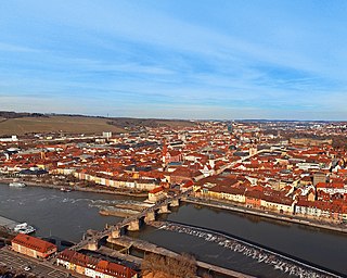
Würzburg basin
| Würzburg basin | |||
|---|---|---|---|
| The Würzburg basin with the river and the heights on the east side | |||
| Systematics according to | Handbook of the natural spatial structure of Germany | ||
| Greater region 1st order | Layer level land on both sides of the Upper Rhine Rift | ||
| Greater region 2nd order | Southwest German layer level country | ||
| Greater region 3rd order | Swabian-Franconian Gau | ||
| Main unit group | 13 → Main Franconian plates |
||
| About main unit | 133 → Middle Main Valley |
||
| 4th order region (main unit) |
133.0 → (without name) |
||
| Natural space |
133.03 → Würzburg basin |
||
| Natural area characteristics | |||
| Landscape type | River valley widening | ||
| Geographical location | |||
| Coordinates | 49 ° 47 '33 .9 " N , 9 ° 56' 36.9" E | ||
|
|||
| local community | Wurzburg | ||
| state | Bavaria | ||
| Country | Germany | ||
The Würzburg basin is a small-scale natural spatial unit (5th order) with the ordinal number 133.03 in the urban area of Würzburg in Lower Franconia .
location
The Würzburg basin (133.03) forms a sub-unit within the nameless main unit 133.0. It is part of the Middle Main Valley (133) and thus a natural area in the main unit group of the Mainfränkische Platten (13). It includes a spacious main valley section, in which the city of Würzburg extends today. In the north the area is bounded by the Würzburg Main side valleys (135.0), which are part of the Wern-Lauer-Platten (135) with their shell limestone soils . To the east are the plateaus in the southern Main Triangle (134.11), which were much less influenced by the river. The Main flows from the south from the Würzburg-Ochsenfurt Main Valley (133.04) towards the city. The Reichenberger Grund (130.00) connects as a Gäu landscape in a south-south-west direction. The west is dominated by the Eisinger Höhe (132.01), the Main then flows in a northerly direction into the Maintal near Veitshöchheim (133.02).
The natural area includes most of Würzburg's urban districts with the exception of Dürrbachtal , Lindleinsmühle and Versbach in the north, and Rottenbauer and Heuchelhof in the south. The new Hubland district , however, extends to the plateaus, while parts of the Steinbach valley can already be assigned to the Eisinger Höhe. The area has been greatly changed by the centuries-old human settlement, so through tunnels were created through the delimiting mountain ranges for the railway lines that end in Würzburg.
Landscape characteristics
The Würzburg basin is dominated by the city of Würzburg. On the eastern side of the river with its gentle valley slopes rising arose the old town with the Cathedral , in the west where much steeper slopes limit the space fortified Ansitz remained of Würzburg (Fürst) bishop , who in the 18th century with the residence in the city was relocated. In the 19th century, the city began to grow rapidly, so that today almost all of the natural space is characterized by urban development. Only the steep slopes on the edge of the valley basin are covered with fruit and vineyards ( Würzburger Stein ).
The basin is not a natural area that is hermetically sealed to the outside, but has gates to the plateaus to the west and east . On the western side, this opening corresponds to the course of the railway lines. The two rivers Pleichach and Kürnach are also important for the human development of the area . The potential natural vegetation (without human intervention) would produce riparian forests with ash and elm trees .
Protected areas
The urban area of Würzburg is almost free of protected areas due to the urban development. Only the bat quarters in the Marienberg Fortress are listed as fauna and flora habitats .
Climate, geology and tectonics
Although the Würzburg basin is part of the Middle Main Valley, it has a special climatic position within this main unit. In winter the temperatures are very high, the only exceptions are inversions in the shadow of the Marienberg. The summer is dominated by high degrees of humidity . These conditions favored the creation of vineyards. In spring and autumn, on the other hand, late frosts can occur.
Similar to the Zellinger valley widening, the Würzburg basin was created under similar tectonic conditions. Tectonic forces raised the corrugated limestone on the western flank, creating the steep slopes on Nikolausberg and Marienberg. The eastern area, on the other hand, is dominated by soils of the Middle Muschelkalk , which rise more extensively over Pleistocene terraces to the transition level between the plateau and the valley.
See also
literature
- Karl-Albert Habbe: The natural space units on sheet 153 Bamberg 1: 200,000 - A bundle of problems and a suggested structure. In: Mitteilungen der Fränkische Geographische Gesellschaft Vol. 50/51 for 2003/2004 . Erlangen 2004. pp. 55-102.
- Horst Mensching, Günter Wagner: The natural spatial units on sheet 152 Würzburg (= geographical land survey 1: 200,000 natural spatial structure of Germany) . Bad Godesberg 1963.
Web links
Individual evidence
- ↑ Geography Giersbeck: Map 152 Würzburg , PDF file, accessed on January 8, 2019.
- ↑ Mensching, Horst (among others): The natural space units on sheet 152 Würzburg . P. 22 f.
- ^ Habbe, Karl-Albert: The natural space units on sheet 153 Bamberg 1: 200,000 . P. 85 (map).
- ↑ Mensching, Horst (among others): The natural space units on sheet 152 Würzburg . P. 23.

