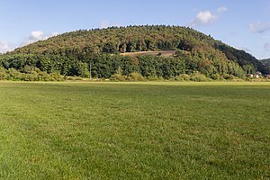
Wolfsberg near Dietfurt
|
NSG Wolfsberg near Dietfurt
|
||
|
The Wolfsberg, view from the south |
||
| location | Dietfurt an der Altmühl , Neumarkt district in Upper Palatinate , Bavaria | |
| surface | 135 ha | |
| Identifier | NSG-00436.01 | |
| WDPA ID | 166352 | |
| Geographical location | 49 ° 1 ' N , 11 ° 36' E | |
|
|
||
| Setup date | 1993 | |
| administration | District of Neumarkt in the Upper Palatinate | |
| particularities | Umlaufberg , geotope | |
The Wolfsberg near Dietfurt is a nature reserve and geotope near Dietfurt in the Upper Palatinate district of Neumarkt in the Upper Palatinate in Bavaria .
It is also a natural area 082.39 in the northern part of the southern Franconian Alb . It is completely surrounded by the Beilngries-Dietfurt valley zone (082.37). The plateau is mainly overgrown by a pine-spruce forest. The underground is karstified.
The nature reserve is located 2 kilometers southeast of Dietfurt. It is located in the Altmühltal nature park and is part of the dry slopes fauna-flora-habitat area in the lower Altmühltal with Laaberleiten and Galgental and the EU bird sanctuary area rocks and hillside forests in the Altmühl, Naab, Laber and Danube valleys .
The 135 hectare area is a circular mountain . Due to its variety of locations, the Wolfsberg has an extraordinarily high number of plant communities, especially the lean and dry locations. The Weiße Laaber flowed east of the Wolfsberg and flowed south of Mühlbach into what was then the Danube . The nature reserve was placed under protection on March 3, 1993 and designated by the Bavarian State Office for the Environment as an important geotope (373R023).
See also
- List of nature reserves in the Neumarkt district in the Upper Palatinate
- List of geotopes in the Neumarkt district in the Upper Palatinate
- Ringwall Wolfsberg
Individual evidence
- ^ Dietrich-Jürgen Manske : Geographical land survey: The natural space units on sheet 164 Regensburg. Federal Institute for Regional Studies, Bad Godesberg 1981. → Online map (PDF; 4.8 MB)
- ↑ Location of the nature reserve in the Bavaria Atlas (accessed on March 1, 2017).
- ↑ 7036-371 dry slopes in the lower Altmühltal with Laaberleiten and Galgental. (FFH area) Profiles of the Natura 2000 areas. Published by the Federal Agency for Nature Conservation . Retrieved November 18, 2017.
- ↑ Dry slopes in the lower Altmühltal with Laaberleiten and Galgental at protectedplanet.net (accessed on March 3, 2017)
- ↑ 7037-471 rocks and hillside forests in the Altmühl, Naab, Laber and Danube valleys. (EU bird sanctuary) Profiles of the Natura 2000 areas. Published by the Federal Agency for Nature Conservation . Retrieved November 18, 2017.
- ↑ Rocks and hillside forests in the Altmühl, Naab, Laber and Danube valleys and Galgental at protectedplanet.net (accessed on March 3, 2017)
- ↑ www.regierung.oberpfalz.bayern.de, ordinance of the nature reserve (accessed on March 1, 2017)
- ↑ www.lfu.bayern.de, profile of the geotope (accessed on March 1, 2017).


