
Booties ponds
| Booty Pond | ||
|---|---|---|

|
||
| Wundschuher pond facing northwest | ||
| Geographical location | Kaiserwald , Styria | |
| Tributaries | Poniglbach | |
| Drain | Poniglbach → Mühlgang → Mur | |
| Location close to the shore | Wound shoe | |
| Data | ||
| Coordinates | 46 ° 55 '23 " N , 15 ° 25' 59" E | |
|
||
| Altitude above sea level | 326 m above sea level A. | |
| surface | 4.9 ha | |
| length | 550 m | |
| width | 140 m | |
| scope | 1.2 km | |

The Wundschuher Ponds are a series of artificial standing water in the Kaiserwald in the Austrian state of Styria . The four main bodies of water, Forster Teich, Neuteich , Wundschuher Teich and Poniglteich were created as fish ponds in the Middle Ages and are fed by the Poniglbach .
Location and surroundings
The water areas are located in the Kaiserwald on the middle course of the Poniglbach in the western part of the community of Wundschuh . The area can be reached via the Wundschuh-Landesstraße ( L 380 ).
The Forster pond is the uppermost and most remote of the Wundschuher ponds. The 4.7 hectare water area is located around 700 m west of the village of Forst and a good 1 km southeast of the Kaiserwaldsiedlung. It can only be reached via forest roads. The Poniglbach is led past the east bank.
The Neuteich with an area of 2 hectares, the smallest of the main ponds. Like the Forster pond, it is located in the middle of the forest and can be reached via forest and hiking trails. In May 2017, the Styrian state government decreed a European protection area ( Natura 2000 ), which covers the entire water body and part of its surroundings with an area of 3.1 ha.
In the center of the ponds is located at 326 m above sea level. A. the Wundschuher pond (formerly Mitterteich ), which, together with two smaller facilities, forms the popular fishing area “Wundschuher See”. The actual Wundschuher pond, the northern section of which merges into swampy terrain, has an area of 4.9 hectares and is called " Hausenteich ". The smallest of the three pond systems is the “ predatory fish pond ”.
About 600 m downstream of the Wundschuher pond, south of the state road, is the Poniglteich (also Menissteich , formerly Mernüßteich ). The stream of the same name is passed on the north side. With a water surface of 6.8 hectares, it is the largest facility, the bank is lined with forest and can only be reached on forest roads. The pond is located on the Helfbrunner level, one of the Emperor Waldterrasse upstream rißzeitlichen Verebnungsfläche.
history
The Wundschuher Ponds were created around 1100 or 1200 by monks of the Rein monastery by damming natural depressions in the ground and lining them with clay . Later they came into imperial possession. According to a deed of donation, in 1642 the ponds went to Count Sigmund Ludwig Dietrichstein, who was retiring from the imperial service and who had previously bought Neuschloß Castle . However, according to the Wundschuh parish website, the ponds were not opened until 1442 under Friedrich III. created as fish ponds . The king , who as the country prince could have the Emperor forest, was in the same year to expand the farmyard, from the estate emerged Neuschloß. The ponds are still owned by the lords of the castle, Enffans d'Avernas.
From 1935 to 1938 and from 1945 to 1948, the shallow, barely moved and very warm ponds were twice the source of malaria spread . Forest aisles that existed at that time encouraged the spread of the anopheles mosquito to neighboring settlements. In 1948, 35 cases of illness were counted in Wundschuh.
In 1973 the Wundschuher pond was redesigned into a swimming lake with a campsite . In addition to shady sunbathing lawns, bathing cabins and a buffet, a parking lot with 500 parking spaces was built on Feldkirchen's new road . By the beginning of July 1973, the tourist association, municipality and state invested 1.7 million schillings in the project. The 9 hectare area was primarily intended to appeal to the residents of the Styrian capital Graz, 17 km away . Thanks to four springs, the pond water, which was on average 24 to 25 degrees Celsius, was constantly renewed in the summer months.
Nature and landscape protection
The ponds are part of the Wundschuher Teiche landscape protection area ( LSG-32 ), which comprises a large part of the southern Kaiserwald. The Neuteich has also been designated as a European protected area No. 45 ( Natura 2000 ) since May 2017 . According to the Fauna-Flora-Habitat Directive , the protection of the four-leaf clover has top priority. In addition, the natural habitat types of mud flats and still waters with floating bodies are to be preserved. The protection contract prescribes the regular removal of reed portions , the provision of pioneer sites and regular draining of the pond as management measures.
Of ornithological interest is the occurrence of some bird species in the pond ditch, which nest in reed belts on the pond banks. These include the coot or the blackcap and the wren , who prefer the alder bushes along the Poniglbach as breeding grounds. In the wet meadows between the ponds, which are covered by grobstängeligen plants and low willow or conical bushes hold Sumpfrohrsänger and Weiden Laubsänger on.
A widely held amphibian is the moor frog , which is about lives at Poniglteich.
photos
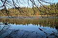
Autumn mood at the Neuteich

Fish trap at the Wundschuher pond

Fishing Resort "Wundschuher See"

Swans
Snow-covered Forster pond

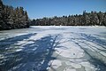
Winter break at the Wundschuher pond

Frozen Poniglteich


Web links
Individual evidence
- ↑ Digital Atlas of Styria: Address and map. (No longer available online.) State of Styria , archived from the original on June 15, 2012 ; accessed on January 20, 2017 . Info: The archive link was inserted automatically and has not yet been checked. Please check the original and archive link according to the instructions and then remove this notice.
- ↑ a b Complete legal regulation for European protected area No. 45 - Wundschuh-Neuteich (AT2247000). Federal Chancellery , accessed on November 21, 2017 .
- ↑ a b c Heribert Reiter: Weitendorf - Wundschuh. In: Communications from the Natural Science Association for Styria , Volume 75, Graz 1939, pp. 188–214. Online PDF , accessed April 4, 2019.
- ^ Wundschuh - Leisure / Clubs> Neuschloß. Wundschuh community , accessed on March 2, 2018 .
- ^ Herbert Paschinger: Styria: Styrian Randgebirge, Grazer Bergland, Styrian Riedelland . Borntraeger , Berlin 1974, ISBN 3-443-16006-9 , p. 145.
- ^ Forest bathing lake Wundschuh invites you. Nine hectares in size - new recreation center 17 km from Graz . In: Kleine Zeitung , edition of July 5, 1973, p. 8.
- ↑ Karl Berndl: The bird world of the Wundschuher ponds and their surroundings. In: Communications from the Natural Science Association for Styria , Volume 74, Graz 1937, pp. 179–187. Online PDF , accessed March 2, 2018.
- ↑ Otto Kepka: General faunistic news from Styria (VI). In: Communications from the Natural Science Association for Styria , Volume 119, Graz 1989, pp. 71–73. Online PDF , accessed March 2, 2018.