
Kaiserwald (Styria)


The Kaiserwald is a forest area in the Austrian state of Styria a few kilometers southwest of the provincial capital Graz . Its geological location, the Kaiserwald terrace , is a clay-covered ice age gravel plateau above the Graz field . The clay dome, which made a local brick industry possible in the past, provides a characteristic groundwater hydrology. From a botanical point of view, it is a mixed forest with pines and pedunculate oaks as the defining trees, which provides a habitat for a wide variety of animal species and thus served as a princely forest for centuries . The area is also significant due to the numerous Roman barrows .
During the Second World War , the Kaiserwald was the scene of armaments activities by the Wehrmacht . Today, large parts of the 30 km² forest serve as a recreational area and commercial forest. Parts are designated as protected areas. Due to its ecological and climate-relevant relevance, the forest is anchored as a green zone in the local development concepts of the surrounding communities. With the Graz-Köflacher Bahn (GKB) and the south autobahn A2, two important traffic routes cross the Kaiserwald.
geography
Location and surroundings
Location within Styria |


The Kaiserwald is located in the West Styria region . In the south it connects to the foothills of the Plabutsch-Buchkogel range and the western Styrian hill country and extends parallel to the Grazer Feld ( Murtal ) to the east . In the west and south, the Kaiserwald terrace is bordered by the lower Kainach valley . The geomorphological limit is in the north at around 365 m above sea level. A. , where the terrain is immediately steepened , in the northwest in the Spatenhof area .
It is difficult to draw a historically accurate border between north and north-west. Until the forest was sold in the 19th century, some parcels beyond what is now Packer Straße were also owned by rulers and were called Kaiserwald. The forest extends for a length of about 13 km in a north-west-south-east direction and measures between 1.5 and 2.5 km in width. The total area is about 30 km² including the enclosed usable area. The Graz city center is approximately 9 km from the northeastern edge of the forest in Pirka removed.
The following communities (from north to south) have a share in the Kaiserwald:
geology

The Kaiserwald terrace is a plateau cut up by ditches, which differs morphologically and geologically clearly from its surroundings. On average, the terrace rises 27 m above the Grazer Feld and 35 m above the Kainachtal. Numerous drillings, wells and cracks in the slope made it possible to recognize a gravel terrace of variously thick clay cover . Due to ongoing erosive processes , only around 55% of the Kaiserwald terrace are now plateau-like, the remainder that has been cut has steeper slopes and therefore less sediment thickness.
Arthur Winkler-Hermaden dated the shape of the terrain to the Günz and Mindel cold ages of the Pleistocene and understood the clay dome as an interglacial clay formation . On the eastern edge of the Kaiserwald terrace there are younger remains of terraces, for example between Windorf and Hautzendorf from the Riss Cold Age , the relics of which can also be found in Graz-Wetzelsdorf . The southeastern continuation of the Kaiserwald terrace between Steindorf, Ponigl and Weitendorf is only 10 m above the level of the main Würm terrace (Grazer Feld) and was assigned to the Helfbrunn level by Winkler-Hermaden. While the Pleistocene emergence of the gravel terrace is now considered certain, Julius Fink's theory of the earth was invalidated. He interprets the loam as multi-phase aeolian drifts from the nearby gravel fields of the Mur . Loess samples with different quartz and feldspar ratios also indicate this.
The average 13 m thick gravel body with silty - sandy admixtures consists of gneiss , crystalline slate , pegmatite , amphibolite and quartz . Carbonate rocks are missing under the partly heavily weathered scree. X-ray diffractometric investigations also revealed kaolinite as a product of feldspar weathering . The clay hood with different clay , silt and sand proportions has an average thickness of 6 m, which, however, varies greatly, and is structured by fossil soil horizons. The boundary between the two layers is sometimes blurred. Due to the relatively high rainfall, agriculturally unusable pseudogleye was created .
The brick industry made use of the clay ceiling for a long time. In 1869, on the initiative of Ferdinand Portugall, the first factory was built in Unterpremstätten, from which the Erste Premstättner Falzziegelfabrik Anton Haas & Co. , founded in 1893, developed. At peak times, between 150 and 200 workers produced over seven million roof tiles a year. At the beginning of the 1970s, four million bricks were still being produced in Wundschuh every year. A more than 10,000 year old molar tooth of a woolly mammoth ( Mammuthus primigenius ) was found in the clay and gravel deposits during construction work in Weitendorf .
Hydrology and hydrogeology
Due to the water-retaining clay hood, most of the drainage on the Kaiserwald terrace is above ground. The determinative rivers Gepringbach and Poniglbach contribute to the heavily furrowed morphology of the plateau. While the Poniglbach erodes the gravel complex, the Gepringbach cuts deeply into the bedrock. The ballast body having only a small water flow due to high loamy play, rests on a base young tertiary fine sediments, crosses out the upper edge thereof above the level of Würmterrassenoberfläche. In the mid-1970s, numerous overflow sources could be mapped at this layer boundary .

A total of 36 springs are distributed over the southern section of the terrace edge. While the water outlets occur continuously on the southwest side at 7–8 m above the valley floor of the Kainach, they occur in the east only between Premstätten and Wundschuh , where the Würm terrace is directly adjacent to the Kaiserwald terrace. The investigation of three selected sources showed discharges of around 1.5 l / s. Because the clay hood largely prevents seepage water and good mixing in the aquifer , the low discharge fluctuation is explained by the even input. After heavy rainfall, meteor waters often accumulate in pools and lowlands in the Kaiserwald . The groundwater recharge takes place in the extreme north of the terrace by infiltration from the southern foothills of the Florianiberg , where the Kaiserwald terrace is in direct contact with the dolomite - sandstone series and coarse-clastic loose sediments of the Graz Paleozoic . In the south, due to the relatively high temperature fluctuations of the said springs, an infiltration through the surface channels could be proven, which open up sand and gravel in the course of their erosive activity. This connection is important in terms of water management insofar as the perennial input ensures regular water withdrawal. In addition, the clay cover provides good protection against contamination of the groundwater , which is often characterized by high iron content and insufficient oxygen supply .
climate
The Kaiserwald is part of the climatic region Grazer Feld with the lower Kainachtal , which is characterized by a continental climate with annual mean temperatures around 8.7 ° C - the January mean is −2.4 ° C, the July mean 19.1 ° C - and an annual precipitation around 833 mm is marked at the ZAMG -station Graz-Flughafen . The growing season (mean temperature ≥ 5 ° C) lasts an average of 230 days from the beginning of March to the beginning of November. The relative sunshine duration , which varies depending on the location, is 42% on an annual average.
In terms of local climatic conditions , however, the terrace shows some significant deviations from the Grazer Feld. With regard to the suitability for the climate, the Kaiserwald terrace is certified to be more favorable residential and commercial locations than the lower Würm main terrace, which is mainly due to the lower risk of inversion . Due to the locally generated cold air, however, the favorable warmth is limited, which results in a classification as "less favored terrace location". On the other hand, a clear advantage over the immediate vicinity is shown in the frequency of fog , which is low at 70 to 100 anniversaries compared to the nearby airport (149 days). At the Helfbrunn level between Steindorf, Ponigl and Weitendorf this effect is only noticeable to a limited extent. Another characteristic of the Kaiserwald terrace is the low to moderate ventilation with an annual mean wind speed of 1.5 m / s. As in the entire Graz Basin, the main direction of flow is northwest. Special conditions with regard to fog, cold air and flow conditions prevail in the cuts of Gepringbach and Doblbach and some smaller side trenches with low wind shear . In the valley of the Doblbach, cold air jams can occur on the GKB embankment and on the motorway route .
As a climate-effective area, the Kaiserwald makes a valuable contribution to sustainable spatial development on a regional level.
Flora and fauna
flora


In terms of stand structure and species composition, the Kaiserwald largely corresponds to the potentially natural forest types of the region. In between, there are some spruce - monocultures , in other places shows the largely closed forest area traces of previous litter . Overall, the plant community of the pipe- grass-rich pine - pedunculate oak forest dominates on moist, acidic gullied soils, in which beech , birch , black alder , mountain ash and bird cherry occur. In addition to dense stands of pipe grass, heather , blueberries and lingonberries form the herb layer . The moss layer is formed by brush moss, gloss moss , fork tooth moss , white moss and even peat moss , which benefit from the acidic soil conditions.
The tertiary Tobelbader Berg is an exception in terms of plant sociology. There the mixed forest , rich in blueberries , dominates , with stands of red pines interspersed with spruce and red beech . The pedunculate oak is stepping back in favor of the sweet chestnut . While in the understory of buckthorn occurs as the dominant type, Blueberry, take bracken , blackberry , cranberry, various broom species , heather, cow-wheat , wood hawkweed , Calamagrostis , Schlängelschmiele and narrow-woodrush one the herb layer. In spring, lilies of the valley and forest hyacinths appear in places .
In some places there is a clear cutting succession . The herb layer is supplemented there by ostrich grasses , rush , ear willow , whorledost and tormentil . There are also neophytes such as glandular balsam or Canadian goldenrod . Special conditions also prevail along the numerous streams and on the pond banks. Black alder fractions with gray alder , ash and white birch are supplemented in the undergrowth by moisture and wetness indicators such as nettles , calf heads , meadowsweet , marsh marigold , cuckoo carnation , brook thistle , marsh pippau , marsh forget-me-not and one berry. In addition to black alder, common oak and birch, various types of willow and the common snowball can be found on the slopes of the clay pits . These are pioneering stages of broken forest communities.
On the road from Zettling to the Kaiserwald in 1927, Josef Eggler discovered the occurrence of round-leaved sundew , an insect-catching bog plant, on heavily soaked peat moss patches, which, however, has not been confirmed in the recent past.
fauna
In addition to the wild fauna typical of the forest with roe deer as a frequent representative, the Imperial Forest is home to a number of bird species, including the golden cockerel and oriole . There was also a population of the capercaillie in the past . After being driven away by felling, 30 specimens of the capercaillie were counted again around 1940. It is reported that Frederick the Quarrelsome had the Gjaidhof hunting lodge decorated with hundreds of cocks' thrusts. According to tradition, even Emperor Maximilian is said to have made a detour to Dobl to kill capercaillie.

The natural streams, such as the meandering Gepringbach , provide valuable habitat for flatworms , caddis fly larvae , crayfish , freshwater shrimp and with adequate water flow brook trout , brown trout and brook lamprey . Representatives of the dragonflies and river maidens can be found here and there. Particular attention was paid to the types of inventory on the brick ponds placed in Unterpremstätten - today a designated nature reserve (see nature and landscape protection ) where amphibians such as green frogs , marsh frog , great crested newt , smooth newt , common toad and tree frogs occur. As breeding birds are mallard and coot , sometimes called food guests herons and night herons found. In addition, the ponds provide a habitat for various types of dragonflies . Between 1964 and 1972, 35 species of netwings were counted in the entire Kaiserwald . In 2005, indications of the occurrence of the endangered brown oak hairstreak were found on the forest bar near Zettling . The forest is also home to at least 25 different longhorn beetles .
Investigations carried out from 1969 on the "tick disease" early summer meningoencephalitis identified the Kaiserwald, next to Mortantsch and the Rötschgraben ( Semriach municipality ), as one of three epidemics, i.e. H. Areas with virus-carrying ticks and infested small mammals , in Styria.
history
Archaeological finds
.jpg)

At the edge of the Kaiserwald terrace there are over 120 Roman barrows , which were first described in detail by Marianne Grubinger in 1935 . Most of the burial mounds date from the 1st and 2nd centuries AD and are arranged in several groups . Due to the modest grave goods, a rural population is assumed. The Joanneum was led by Grubinger items such Dreifußschalen, jars and glass cups next few bronze coins, which primarily Emperor Hadrian show. According to prehistoric customs, the handmade clay contained a lot of mica and quartz sand , decorations with rows of notches date back to the La Tène period . A local peculiarity of the finds is the lack of folded cups, lamps and Roman bronze objects.
Grubinger recognized the usual Hallstatt-time burial form in the Roman province , in which a corpse was burned directly at the grave site and the corpse was poured into vessels. Then everything was placed in the pyre ashes, which were enclosed in round or rectangular stone walls. In the Kaiserwald, the building material had to be brought in from afar, for example the Leithakalk from the Wildoner Berg . The chemical examination of one of the graves revealed a nitrogen-rich , fat-free organic mixture, probably a plant resin . An earlier find that was kept in the Gjaidhof for a long time is the Roman grave relief that is now attached to the church wall of Maria im Dorn zu Dobl . Grubinger sees in it a portrait stone that shows a Roman soldier with wife and child as well as a second wife, possibly his mother. This work is said to have been made as part of a larger grave monument of wealthy people on the death of the child.
Grubinger associates the abandonment of the settlements and the end of the use of the burial ground with the Marcomann Wars of the Emperor Marcus Aurelius , which also led to an economic decline in the regional capital Flavia Solva , for example .
Further finds were provided by investigations by Siegfried Stadlhofer, who between 1986 and 1993 made various small finds with the help of a metal detector . The case discovered brooches were in the Fund reports in 1996 of the Federal Monuments Office published, was being sued for over recent grave robberies in the area Slavkov Forest. Already Grubinger had found dozens of earlier openings of burial mounds by farmers or "treasure hunters", which were expressed by depressions at the top of the hill.
The largest grave fields are in the cadastral communities of Fading and Dietersdorf. A burial ground comprising 16 tumuli , located by Grubinger in the Zwaring area, has not yet been located. The Dietersdorfer barrows in the Schröttengraben area were last extensively examined a few years ago. A body grave in the form of a stone sarcophagus was discovered in this area as early as 1974 . Due to planned ponds, several emergency excavations were carried out between 2008 and 2010 by the Federal Monuments Office and the non-profit association Archäologieland Styria. At the foot of the trench, not only Roman but also Bronze Age settlement remains from the 14th and 13th centuries BC were found. To be exposed. The investigation of the burial mounds brought new discoveries: on the one hand, a grave filled with Roman bricks for unexplained reasons , and on the other, an atypical shallow grave , whose carelessly deposited corpse fire indicates a poor grave. Most important, however, were ceramic finds that can be dated back to the Lasinja culture of the Copper Age . Whether the more than 6000 years old, pre-Roman finds point to settlements or graves, could not be clarified for the time being. All barrows in the Kaiserwald have been under monument protection since 1999 .
The Imperial Forest is also assumed to be the site of a Roman portrait head made of marble . However, the Landesmuseum Joanneum suspects that this work of art was stolen from Apollonia by members of the Wehrmacht during World War II and then deposited in the Styrian Forest. In 2015 the restitution to Libya was still outstanding.
etymology


Only with the Josephinische Landesaufnahme in 1787 did a large part of the forest receive its current name. Before that, the forest area - with a few exceptions - was called Imperial Khart . The earlier meaning of the word "hard" or "khart" was no longer aware in the 18th century, as evidenced by the incorrect use in the then municipality of Oberpremstätten . Originally, the term was used to designate a loose tree population, which is condensed into a forest in places, and is therefore rather a name for loosely connected forests. The owner's status was first reflected in the forest name under Ernst the Iron , when it was called "the Duke's Forest". After the Styrian sovereign princes had achieved the dignity of emperors, the forest was referred to in 1471 as "Roman Emperor's Wood". Until the 18th and 19th centuries, the official name was Forst zu Tobel or, derived from it, Dobler Forest . The Old High German "Dobl" means something like forest ravine or forest cut.
History of ownership and use
After the German-Franconian kings in Slavic Carantania came to power , the Kaiserwald was in sovereign possession from 788. The forest right was a shelf and could be assigned to nobles, who in this way also obtained the right to clearing and, consequently, to colonization . Presumably through an official fiefdom , this right came from the Aribones dynasty to the Otakare and Traungauers in the High Middle Ages , who at that time provided the margraves and dukes of Styria. Numerous donations have resulted in complex legal relationships over the centuries, with the western and southwestern edges of the forest being separated from the old forest early on, for example through clearing of farmland in the Carolingian village of Fading. From the 13th century on, the history of the forest is closely linked to Gjaidhof Castle . The estate was an imperial hunting seat and later also housed the Prince's Forestry Office . The era of princely hunts began with the last Babenberger , Friedrich the arguable , and ended with Charles VI. While observing a pack of deer from the castle, the latter is said to have made the exclamation “This is an imperial pleasure!” One evening. For a long time, the Kaiserwald also supplied timber and armor for lordly buildings in Graz, around 1579 for the expansion of the cistern on Schloßberg .
Due to its role as a protected forest , the local farmers had no or only limited rights of use, for example in the form of pastures. These grazing rights divided the forest into sections, which were last written down in 1773 and 1812. In addition, the residents of the settlements on the edge of the forest had to cope with challenges again and again; a wolf and wild boar plague has come down to us from 1636. Parts of the forest traversed by mill and church paths were left to the neighboring manors , such as the Counts of Montfort . The wild ban was in the entire Kaiserwald, including on those areas that belonged to noble landlords, the sovereign. Violations of both hunting and forest law were not infrequently punished with torture chambers or imprisonment in the Graz casemates .
After the Gjaidhof had been privately owned since 1780, it was decided to sell the Kaiserwald for economic reasons. Already under Ferdinand II and Maria Theresa there had been efforts to sell the forest. But only after the abolition of serfdom by Joseph II was the Dobler Forest, with a total area of 2045 yoke , put up for auction on May 5, 1825 . A commitment table adapted to the Franziszeische cadastre summarized the sales areas. With the highest bid of 81,060 guilders , three representatives from the united peasantry acquired the properties, which were ultimately divided among 517 buyers from 29 surrounding communities.
The final land register order was not established until 1866, and the hunting rights were acquired by Neuschloß Castle .
Confession table
- Sales name: place name of the property (1825); Only areas in the Dobler Forest are listed.
- Property (s) : Property numbers in the Franziszeischen Cadastre (1820/1823); the center of the property is located in each case.
- Cadastral municipality : cadastral municipality according to the territorial status at that time.
- Area : Area information in yoke ( yrs ) and square fathoms (qkl.) As well as converted into hectares (ha); 1 Austrian yoke corresponds to 1600 square fathoms and 0.575464 hectares.
| Sales description | Plot (s) | Cadastral parish | surface | annotation | |
|---|---|---|---|---|---|
| Field in the Birkawald in the Dobler Forest | 459 | Unterpremstätten | 1 year 191 qkl. | 0.64 ha | |
| Meadow in the Birkawald in the Dobler Forest | 458 , 460 | Unterpremstätten | 2 years 542 qkl. | 1.35 ha | |
| Meadows in the haywood forest in the Dobler forest | 466 , 469 , 480 | Unterpremstätten | 5 years 229 qkl. | 2.96 hectares | |
| Upper khart with softwood | 432d | Unterpremstätten | 43 years 1579 qkl. | 25.31 hectares | with hardwood |
| 432b / c | 16 years 804 qkl. | 9.5 ha | mixed wood | ||
| 432a | 10 years 64 qkl. | 5.78 hectares | Hut willows | ||
| 431 , 433 | 50 years 1094 qkl. | 29.17 hectares | |||
| Farchrieglwald with softwood | 434a / d , 437 , 438a / b | Unterpremstätten | 115 years 934 qkl. | 66.51 ha | with hardwood |
| 438c | 5 years 137 qkl. | 2.93 hectares | mixed wood | ||
| 434b | 25 years 1069 qkl. | 14.77 hectares | Hut willows | ||
| 435 , 436 | 25 years 719 qkl. | 14.65 hectares | |||
| Untere Khart under the Poniglbrücke between the Lembacher and Farchrieglwald area to the Schwabenkreuz | 439 , 440 | Unterpremstätten | 30 years 121 qkl. | 17.31 ha | Hutweide |
| Mühlleiten and Birkawald with softwood | 442 , 435-455 , 462 , 464 | Unterpremstätten | 418 years 1343 qkl. | 241.03 ha | with hardwood |
| 457 | 2 years 1354 qkl. | 1.64 ha | Hut willows | ||
| 443 , 444 , 448-452 , 456 , 461 , 463 | 66 years 596 qkl. | 38.19 ha | |||
| Ameisrieglwald with softwood | 485 | Unterpremstätten | 66 years 437 qkl. | 38.14 hectares | with hardwood |
| 485 | 6 years 433 qkl. | 3.61 ha | mixed wood | ||
| 485 | 2 years 863 qkl. | 1.46 ha | Hutweide | ||
| 485 | 1344 qkl. | 0.48 ha | |||
| Haywood forest with softwood | 486 , 490 , 491 | Unterpremstätten | 284 years 1013 qkl. | 163.8 ha | with hardwood |
| 486 , 493 | 8 years 1391 qkl. | 5.1 ha | Hut willows | ||
| 465 , 468 , 470 , 471 , 484 , 487 , 492 , 495 | 25 years 1288 qkl. | 14.85 ha | |||
| Dietersdorfer Wald or actually Birkgraben and pond forests between the Zettlinger and Kastner Mühlweg, with softwood | 746 , 747 | Dietersdorf | 308 years 1073 qkl. | 177.63 hectares | Hutweide |
| 748-751 , 753 | 13 years 1040 qkl. | 7.86 hectares | |||
| Steindorfer Khart between the Wundschuher Kirchweg and the Steindorfer municipality, with softwood | 1333 , 1337 | Yes | 157 J. 338 qkl. | 90.47 ha | with hardwood |
| 1333 | 17 years 1386 qkl. | 10.28 ha | Hut willows | ||
| 1334 , 1335 , 1338, 1339 | 16 years 1563 qkl. | 9.77 hectares | |||
| Birkkogl or Birkgraben and Khart on the Wundschuher pond sides between the Wundschuher Kirch- and Kastner Mühlweg, with softwood | 1340 , 1345 | Yes | 229 J. 893 qkl. | 132.1 ha | with hardwood |
| 1342 , 1345 | 27 years 1292 qkl. | 16 ha | Hut willows | ||
| 1341 , 1343 , 1344 , 1346 , 1347 | 13 J. 769 qkl. | 7.76 hectares | |||
Second World War
In the course of structural measures to create “Groß-Graz”, building activity began in 1939 in the Kaiserwald as well. A munitions plant (Muna) was built near today's Kaiserwaldsiedlung in 1941/1942 with the expansion of the war towards south- east Europe , which was made accessible by an additional 5 km long rail line from the Premstätten-Tobelbad station. The tracks of the standard gauge Muna connecting railway, dismantled immediately after the end of the war, were subject to the strictest confidentiality and were not included in the GKB's plans . Railway historian Sepp Tezak was hardly able to gain any knowledge even from conversations with contemporary witnesses. The brick industry in Unterpremstätten was pushed with regard to residential construction. On May 15, 1942, construction work in the Kaiserwald was stopped with the official reason that it was "not war-important". The forced laborers employed there were transferred to Germany. 20 people died during the construction work and were buried on site. As can be seen from an activity report of the field equipment command, the construction work should be resumed in October 1944. The responsible high command gave orders to prepare the site of the planned Muna for a larger ammunition depot using the building that was already in the shell. For this purpose, 200 Finn tents to accommodate the ammunition and 1200 meters of light rail track should be allocated. According to the report, difficulties in expanding the sidings were the lack of rail material, the supply of ballast for the substructure and a lack of workers. On October 16, 1944, the Allies launched a targeted air raid on the ammunition plant in the Kaiserwald. A squadron of around 30 aircraft coming from the west dropped around 240 bombs weighing 250 kg and 500 kg at 12 noon, thus destroying three hectares of forest. Three civilians were killed, seven injured and nine homeless.
In addition, a camp of the Reich Labor Service (RAD) had existed in the Kaiserwald since 1938 . For the construction of the Steindorf camp (RAD department 6/360), the responsible authority leased private commercial areas that were left to the rightful owner after the end of the war. The workforce was busy regulating the Kainach , among other things , and has since been reflected in the population of the community of Zwaring-Pöls , which reached a temporary high in 1939. In January 1942, 160 people had to leave the camp, which resulted in the cessation of work. In 1945 the buildings were demolished.
From autumn 1946 the demining service in the Kaiserwald dealt with the destruction of war material. In 1949 the Steirerblatt reported on the controlled detonation of bombs and other explosives from the ammunition depot in Kalsdorf near Graz . The ammunition was carted with a truck into a clearing in the forest and detonated from a bunker 300 m away . The residents of the surrounding villages were warned beforehand by a siren . The constant blasting resulted in pronounced young forest vegetation without undergrowth . The grass burned down quickly due to glowing explosives or incendiary devices and took on a dry, yellowish shape, so that the clearing in combination with the large explosive craters resembled a “ lunar landscape ”. Due to the high risk of fire, the operations could only take place in winter. In the summer there were clearing parties piling mines and other salvaged explosives. By February 1949, 140 tons of war material had been defused in the Kaiserwald in this way.
Some of the relics of the Wehrmacht buildings can still be seen today. In addition to an unfinished-looking reinforced concrete hall, there are the foundation walls of several barracks as well as some stone water tunnels and a large shooting range with three ball traps . Since there are only a few records of Nazi activities in the Kaiserwald, finds and ruins, especially regarding the exact route of the connecting railway, leave room for speculation. Information about the location and extent of the properties is provided, for example, by online ALS data for the state.

Hall

Shooting range
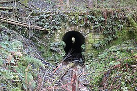
Water tunnel

Railway line

RAD warehouse in Steindorf


Younger story
After the Second World War, the forest was increasingly assigned a recreational function. As early as 1947, there were concrete plans to establish an own Styrian film production facility in the Kaiserwald . For this purpose, Austria Alpenland Avantgarde-Film GmbH ("Alpenfilm") planned to couple seven diagonally positioned houses on a site encompassing twelve yokes - today's Kaiserwaldsiedlung - and to convert them into recording studios and offices. In addition, a hotel for actors was to be built and an existing pond was to be converted into a bathing facility. The Steirerblatt called the building project a "valuable contribution to the reconstruction of the country". In contrast to the already world-famous Viennese film , "Austrian" films should expressly be produced. Details of the first planned film have even been announced. "Our star is sinking" should stand for a warning of the emerging atomic energy and show one of Austria's greatest film actors in the lead role. In the end, the project turned out to be unfeasible for reasons of cost and the film production was transferred to Thalerhof Airport , where several feature films were made by 1954.
Plans for the future to develop the Kaiserwald into a modern local recreation area for the urban population of Graz were less concrete . An expressway should make it possible to reach the forest from the city in a few minutes. The excavation material for an artificial swimming lake was intended for road construction. These and similar ideas were debated in the Forum Stadtpark in February 1966 following a discussion about the development goals of the city of Graz and at least partially implemented to this day.
On March 16, 1961, one of the largest forest fires in Styria occurred in the Kaiserwald . Triggered by flying sparks from a GKB locomotive, five hectares of young forest burned down. Only by reinforcing the Graz professional fire brigade could the teams of the five surrounding communities get a grip on the more than one kilometer long firebreak. In November 2008, a Piper PA-34 crashed in the Kaiserwald between Zwaring and Wundschuh, three people died.
In February 2020, it became known that Strabag was carrying out an environmental impact assessment for a planned landfill site in the local recreation area of Premstätten. Both the Pro Premstätten citizens' initiative and Mayor Anton Scherbinek announced a protest.
use
Settlements

The Kaiserwaldterrasse has been largely spared from settlement activity to this day. The reason for this is not only the former function as a princely hunting forest, but also the loamy soil texture, which restricts agricultural use in many places. In addition, none of the streams has sufficient water flow for the mill to operate. There are only a few contiguous districts such as in the Unterpremstätten area or the Kaiserwaldsiedlung, a former aviator settlement near Zettling . Another recent settlement, which had to be replaced by forest areas, is the Rehweg settlement on Packer Bundesstrasse, which also belongs to the municipality of Premstätten. Due to its importance as a green zone and ecological guiding function in the regional settlement model, the local development concepts of the communities (OEK) and the regional development program (REPRO) for the Styrian central area in the Kaiserwald area do not provide for any further construction activities.
traffic


The Graz-Köflacher Bahn (GKB) , originally designed to develop the western Styrian lignite mining areas , has been running through the Kaiserwald since it opened in 1859. The route initially runs between Windorf (municipality of Seiersberg-Pirka) and Unterpremstätten along the edge of the forest and then crosses the forest on a straight line in the direction of Lieboch . Only the route of the Wehrmacht connecting railway, which led deep into the forest and which made it necessary to expand the Premstätten-Tobelbad station, is still recognizable.
With the south autobahn A2, in this section also Europastraße 66 , one of the most important traffic routes in Austria runs through the Kaiserwald. The construction of the 8.5 km long section between today's Graz-West node and Lieboch began in 1969. This fifth construction lot on the Styrian South Autobahn was named "Kaiserwald Section" and required 2.6 million m³ of earth moving for the superstructure and substructure as well as the construction of the provisional roadway. At the same time, the Lieboch junction including the access ramps for Radlpass Straße was built. The cost of the contract was estimated at 125 million schillings and thus amounted to more than half of the annual federal budget for the construction of the autobahn in Styria. A new construction method was used, which was presented in January 1971 at an information conference in the Graz building center by the “Underground” working group of the Research Society for Road Construction in the Engineers and Architects Association together with a working committee of the Austrian lime industry. By adding quicklime , it was possible to make a significant contribution to soil stabilization on the loamy Kaiserwald terrace and on the Kainachboden. Lime sand and gravel had already been used for the same purpose on municipal and goods roads , but not in motorway construction. The Graz-Kaiserwald service area and restaurant are located on a leveling over the Gepringbach .
In addition, five state roads cross the forest, from north to south these are Packer Straße B 70, Premstättenerstraße L 376, Muttendorferstraße L 374, Predingerstraße L 303 and Wundschuhstraße L 380.
Recreation
A large part of the imperial forest is classified in the forest development plan (WEP) of the state in the category of forests with a high welfare function . There are numerous community hiking trails spread across the entire forest area, including the Dobler circular hiking trail, the Kneipp trail near Zwaring or the educational forest trail at the Wundschuher pond. In the southern part between Dietersdorf and Ponigl, the Grazer Umland-Weg (GUW) is a long-distance hiking trail that crosses the Kaiserwald terrace. The Erzherzog-Johann -Radweg (state cycle path R 9) leads along the L 374 to Stainz , an unmarked cycle path accompanies the L 303 to the Kaiserwaldsiedlung. In addition, the unpaved Peter-Rosegger-Weg between Zettling and the Kaiserwaldsiedlung is open to cyclists.
The Wundschuher Pond , one of several artificially created standing waters on the Poniglbach , was redesigned in 1973 into a swimming lake with a campsite , which was primarily intended as a recreation center for the urban population of Graz. For some years now, the water area, also known as Wundschuher See, has been used as a fishing pond , like the Windorf pond and the Klingerteich at Unterpremstätten. All three bodies of water are part of landscape protection areas.
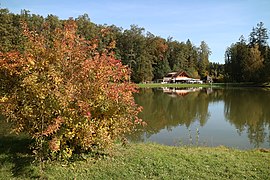
Booty Pond
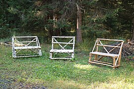
Birch or spruce wood benches

Archduke Johann Cycle Path (R 9)

Island in the Windorf pond

Hiking trail on the Neuteich


Nature and landscape protection
In addition to the recreational character, nature and landscape protection are of great importance. As of 2017 there are two nature reserves , landscape protection areas and protected landscape parts , an area designated by the state of Styria as a " biotope " and a European protection area ( Natura 2000 ). The latter includes the Neuteich, the smallest of the four Wundschuher ponds , and protects the four-leaf clover ( Marsilea quadrifolia ) found there in accordance with Directive 92/43 / EEC (Fauna-Flora-Habitat Directive) of the European Union . Another highlight is the nature reserve near Unterpremstätten, which is protecting a number of ponds from the former clay quarrying area. The brick ponds outside the forest had already been filled in for housing construction in 1989, which led to the disappearance of some rare plant species. The regional development program for the Styrian central area provides for a biotope network with the green areas of the Mur floodplains in Werndorf for the Kaiserwald in the Wundschuh area .
| photo | designation | Abbreviation | location | surface | Legal basis | Facility |
|---|---|---|---|---|---|---|

|
Unterpremstätten: Gepringbach | Biotope 6168 |
Premstätten location |
6.55 ha | (Biotope mapping on behalf of the Styrian state government) | 4th June 1981 |

|
Western mountain and hill country of Graz | LSG 29 |
Seiersberg-Pirka location |
5720 ha | Ordinance of the Styrian state government | June 29, 1981 |

|
Booties ponds | LSG 32 |
Premstätten , Dobl-Zwaring , Wundschuh location |
576 ha | Ordinance of the Styrian state government | June 29, 1981 |

|
Pond in Unterpremstätten | GLT 104 |
Premstätten location |
2.67 hectares | Notification of the BH Graz-Umgebung | May 19, 1983 |

|
Windorf pond | GLT 108 |
Seiersberg-Pirka location |
6.05 hectares | Notification of the BH Graz-Umgebung | April 13, 1988 |

|
Doblwiesen wetland | NSG c 78 |
Dobl-Zwaring location |
1.02 ha | Ordinance of the BH Graz-Umgebung | May 11, 1992 |

|
Sections of the former clay quarrying area | NSG c 65 |
Premstätten location |
3.21 ha | Ordinance of the BH Graz-Umgebung | June 10, 1997 |

|
Wundschuh-Neuteich | FFH No. 45 |
Wundschuh location |
3.1 ha | Ordinance of the Styrian state government | 4th May 2017 |
- ↑ The landscape protection area Westliches Berg- und Hügelland von Graz (LSG 29) comprises only a small part of the Kaiserwald in the municipality of Seiersberg-Pirka and consists mostly on the Plabutsch-Buchkogelzug and in the Thaler basin.
In addition, three objects are designated as natural monuments in the Kaiserwald or in the area of the Kaiserwald terrace. In 1979 a summer linden tree ( Tilia platyphyllos ) and a pedunculate oak ( Quercus robur ) were placed under monument protection in the municipality of Dobl-Zwaring , and parts of the basalt quarry in 1985 in the municipality of Wildon (then the municipality of Weitendorf) .
reception

In the neighboring community of Wundschuh, the Kaiserwald indirectly found its way into heraldry . The municipal coat of arms, awarded in 1965, shows a black snake with a gold crown between two spruce trees. This motif goes back to the Middle High German place name “Wurmschach”, where worm denotes a snake and schach denotes a single forest. The forest remains between the agricultural and commercial areas of the Grazer Feld are still called Schachen forests today. An actual "snake forest " is said to have been in the form of a swamp area in the Kaiserwald. In order to be protected from the bites of the poisonous reptiles, high fur boots had to be worn during clearing work.
The Kleine Zeitung printed on 5 November 1933, the history of the robber chief from Kaiserwald Karl Reiterer on the title page. The action is set in the Kaiserwald from 1787, where a feared band of robbers is up to mischief. When the merchant of the wealthy Graz merchant Oswald Morain does not return from Trieste one day , he sends his maid Rosi to find him. The young girl disguises herself as a boy and drives to Premstätten in a car. After being attacked by the robbers, she not only finds the missing trader Steffl, but also realizes with horror that her lover Hansl, who works as an ox buyer for a master butcher , has become the robber captain . Hansl had gambled away the 400 guilders for his last order in a Puntigamer tavern and, for fear of returning empty-handed, accompanied his opponents, two robbers, to the Kaiserwald. Rosi and Steffl report in Graz about their misery, whereupon the military is sent to track down the bandits in the undergrowth of the forest. In Graz the robbers, among them the "Schinderpeter" and the "Rote Jöbstl", are being tried. They escape the gallows , but receive prison sentences of several years in the Reckturm . Deathly sad about the fate of her lover, Rosi turns to the emperor himself when Joseph II visits the city. She begs the monarch for mercy for her Hansl until he shortens his prison sentence. Rosi and Hansl later get married and set up the “Zum steirischen Hiesel” inn on Griesplatz.
The name Kaiserwald is reflected in the name of the motorway service station in three street names in the area. So exist in Weitendorf street On Kaiserwald and both the Emperor forest settlement (municipality Premstätten) and in box (municipality Wundschuh) a Kaiserwaldweg . The name for a street of the same name in the 9th district of Graz, Waltendorf , more than 10 km away , however, goes back to a local wooded area.
Literature and maps
- Marianne Grubinger : The Roman graves in the Kaiserwalde south of Graz . In: Blätter für Heimatkunde , Volume 13, Historischer Verein für Steiermark , Graz 1935, pp. 101-107.
- Hans Peter Leditzky & Hans Zojer: On the hydrogeology of the Kaiserwald terrace . In: Communications from the Department of Geology, Paleontology and Mining at the Landesmuseum Joanneum , Issue 39, Graz 1978, pp. 85–97.
- Heinrich Purkarthofer : Kaiserwald, Gjaidhof zu Dobl and Tobelbad. From forest and farm forest, forest office and bath . In: Journal of the Historisches Verein für Steiermark , Volume 78, Graz 1987, pp. 87–119.
- Austrian map 1: 50,000, sheet 4229 ( UTM ). Federal Office for Metrology and Surveying .
Web links
Individual evidence
- ↑ a b c d e Hans Peter Leditzky & Hans Zojer: On the hydrogeology of the Kaiserwald terrace . In: Communications from the Department of Geology, Paleontology and Mining at the Landesmuseum Joanneum , Issue 39, Graz 1978, pp. 85–97. Online PDF , accessed April 3, 2019.
- ↑ a b c d Heinrich Purkarthofer : Kaiserwald, Gjaidhof zu Dobl and Tobelbad. From forest and farm forest, forest office and bath . In: Journal of the Historisches Verein für Steiermark , Volume 78, Graz 1987, pp. 87–119.
- ↑ Measurement with Amap Fly 5.0 / ÖK 1: 50,000 (territorial status: 2010). Federal Office for Metrology and Surveying .
- ↑ Helmut Flügel : On the neogene-Quaternary morphogenesis and karstification of the Plabutsch train west of Graz (Styria) . In: Communications from the Natural Science Association for Styria , Volume 113, Graz 1983, pp. 15–23. Online PDF , accessed on January 16, 2018.
- ↑ Hans Peter Leditzky: The hydrogeological conditions in the southern Grazer Feld and in the lower Kainachtal . Unpublished report, Graz 1975.
- ↑ a b Groundwater body (GK) 100097 Grazer Feld. Hydrogeological characterization . Federal Environment Agency . Document download
- ↑ Digital Atlas of Styria: Geology & Geotechnics. State of Styria , accessed on November 19, 2017 .
- ↑ Julius Fink: The southeastern roof of the Alps . In: Communications from the Austrian Soil Science Society , Volume 6, Vienna 1961.
- ↑ Hans Kolmer: About loess sediments of the Mur valley . In: Communications from the Natural Science Association for Styria , Volume 98, Graz 1968, pp. 11-16. Online PDF , accessed on January 16, 2018.
- ↑ Helmut wing : The geology of the Grazer Bergland. In: Communications from the Department of Geology, Paleontology and Mining at the Landesmuseum Joanneum , Issue 36, Graz 1975, p. 153. Online PDF ( Memento from February 1, 2015 in the Internet Archive ), accessed on January 16, 2018.
- ↑ a b Herbert Paschinger: Styria: Steirisches Randgebirge, Grazer Bergland, Styrian Riedelland . Borntraeger , Berlin 1974, ISBN 3-443-16006-9 , pp. 142-149.
- ↑ a b c Bernd Gassler: The history of Unterpremstättens 1848–1995 . In: Walter Brunner (Ed.): Unterpremstätten in the course of time , pp. 566–652.
- ↑ Gravel terraces and mammoths: witnesses to the Ice Age (information board). (PDF) Kulturpark Hengist, accessed on November 22, 2017 .
- ↑ Alexander Salamon (Red.): Water supply plan Styria 2015 . State of Styria - Department 14 - Water Management, Resources and Sustainability, Graz 2015, p. 31. Online PDF , accessed on January 16, 2018.
- ↑ Herwig Wakonigg: Climate Atlas Styria - Chapter 4: Precipitation. Central Institute for Meteorology and Geodynamics . Online PDF , accessed on January 16, 2018
- ↑ Herwig Wakonigg: Climate Atlas Styria - Chapter 2: Temperature. Central Institute for Meteorology and Geodynamics . Online PDF , accessed on January 16, 2018.
- ↑ Herwig Wakonigg: Climate Atlas Styria - Chapter 1: Radiation. Central Institute for Meteorology and Geodynamics . Online PDF , accessed on January 16, 2018.
- ↑ Graz field climatic region. State of Styria , accessed on November 29, 2017 .
- ↑ 23.1 less favored terrace locations. (PDF) State of Styria , accessed on November 29, 2017 .
- ↑ a b Local development concept 4.0 including community development plan. (PDF) Marktgemeinde Unterpremstätten , October 20, 2009, accessed on January 22, 2018 .
- ↑ a b Josef Eggler: Forest investigations in Styria (oak and pine mixed forests) . In: Communications from the Natural Science Association for Styria , Volume 79/80, Graz 1951, pp. 8-101.
- ^ A b c Josef Eggler: The plant communities around Graz . In: Repertorium specierum novarum regni vegetabilis , supplement 73, Graz 1933, pp. 1-216.
- ↑ a b c d e f g Helwig Brunner & Werner E. Holzinger: Nature and landscape in Unterpremstätten . In: Walter Brunner (Ed.): Unterpremstätten in the course of time . Self-published by the market town of Unterpremstätten 1995, pp. 653–674.
- ↑ a b The capercaillie mates in the Kaiserwald ... Hunting paradise one hour from Graz . In: Kleine Zeitung , issue of April 23, 1940 (No. 112), p. 5.
- ↑ Johann Gepp: Die Netzflügler (Megaloptera, Raphidiodea, Planipennia) of the Kaiserwald south of Graz (with a zoographic analysis) . In: Communications from the zoological department at the Landesmuseum Joanneum , vol. 3, issue 1, Graz 1974, pp. 11–28. Online PDF , accessed on January 16, 2018.
- ↑ Anton Koschuh & Rupert Fauster: The Brown Oak Zipfelfalters Satyrium ilicis (Esper, 1779) (Lepidoptera: Lycaenidae) in Styria (Austria). In: Contributions to entomofaunistics . Volume 6, Vienna 2005, pp. 65–86. Online PDF , accessed April 3, 2019.
- ↑ Soon vaccine against tick disease . In: Landwirtschaftliche Mitteilungen , edition of June 15, 1972, p. 4.
- ↑ a b c d Marianne Grubinger : The Roman graves in the Kaiserwalde south of Graz . In: Blätter für Heimatkunde , Volume 13, Graz 1935, pp. 101–107.
- ↑ Dietersdorf finds from the Kaiserwald. Kulturpark Hengist, accessed on March 5, 2018.
- ↑ Hannes Heymans: Roman fibulae and bronzes from the Kaiserwald, the area around Graz and from western Styria in the Stadlhofer collection . In: Find reports from Austria 1996 , Volume 35, 1996 [1997], pp. 141–164.
- ↑ The Dioskur vom Kaiserwald. Roman graves make history . In: Weststeirische Volkszeitung , edition of July 6, 1973, p. 14.
- ^ Dietersdorf tumulus field Fading-Kaiserwald. Kulturpark Hengist, accessed on November 23, 2017 .
- ↑ Zwaring barrows in Zwaring; Kaiserwald. Kulturpark Hengist, accessed on November 23, 2017 .
- ↑ Wolfgang Artner, Birgit Schweiger: Traces of prehistoric cultures in the lower Kainachtal . In: Gottfried Allmer (Ed.): Zwaring-Pöls. History, culture and present of a western Styrian community in the Lower Kainachtal , community Zwaring-Pöls 2014, pp. 28–31. Online PDF , accessed on January 16, 2018.
- ^ The archaeological and numismatic collections of the Joanneum during the Nazi era. (PDF) Landesmuseum Joanneum , 2015, accessed on November 22, 2017 .
- ^ Walter Brunner : History of the habitat and its settlement . In: Unterpremstätten through the ages , self-published by the Marktgemeinde Unterpremstätten 1995, pp. 17–117.
- ^ A b c Wolfgang Artner & Birgit Schweiger: Prince and Archdiocese of Salzburg . In: Gottfried Allmer (Ed.): Zwaring-Pöls. History, culture and present of a western Styrian community in the Lower Kainachtal , community Zwaring-Pöls 2014, pp. 37–39. Online PDF , accessed on January 16, 2018.
- ↑ a b Josef Steiner-Wischenbart: The hunting lodge in the Kaiserwald. The "Gjaidhof" in Dobl and its history . In: Kleine Zeitung , edition of July 4, 1941, p. 8.
- ↑ St G Dobel 7409/1825.
- ^ Sepp Tezak : History of a GKB train station. In: Eisenbahnverkehr aktuell , issue 9 (1992), pp. 34–35.
- ↑ CAMO inventory 500, Finding aid 12474: File 280. Documents of the deputy. General Command of the XVIII. (Geb.) Army Corps: Activity report of the Feldzeugkommando 1944 Part II: July 1 - December 31 , 1944 , p. 11. Online , accessed on April 2, 2019.
- ^ Walter Brunner : The aerial warfare in Styria 1941–1945. Adapted from the Weissmann Collection . In: Mitteilungen des Steiermärkisches Landesarchivs , Volume 38, Steiermärkisches Landesarchiv 1988, p. 92. Online PDF , accessed on January 16, 2018.
- ^ Field post to the Steindorf camp near Graz. Ebay , accessed November 23, 2017 .
- ↑ Gottfried Allmer: The time between 1938 and 1945 . In: Zwaring-Pöls. History, culture and present of a western Styrian community in the Lower Kainachtal , community Zwaring-Pöls , pp. 362–368. Online PDF , accessed on January 16, 2018.
- ^ Moonscape in the Imperial Forest. 140 tons of war material destroyed - demining service a dangerous job . In: Das Steirerblatt , edition of February 27, 1949, p. 7.
- ↑ Thread Kaiserwald. unterirdisch.de, August 22, 2012, accessed on November 23, 2017 .
- ^ Styrian film city in the Kaiserwald. “Alpenfilm” builds recording studios - “Our star is sinking” is the first film . In: Das Steirerblatt , edition of June 28, 1947, p. 4.
- ^ A b Robert Engele: Thaliwood - when Graz was a film metropolis . In: Back then in Graz. A city tells its story. Styria , Graz 2010, ISBN 978-3-222-13286-5 , pp. 148-150. Online , accessed November 27, 2019.
- ↑ Recreation center in the Kaiserwald near Graz . In: Kleine Zeitung , edition of February 15, 1966, p. 12.
- ↑ One of the biggest forest fires in Styria. The Kaiserwald was on fire on Thursday evening - six fire brigades in action . In: Truth , March 18, 1961 edition, p. 5.
- ^ Three dead in a plane crash near Graz. Die Presse , November 2, 2008, accessed December 1, 2017 .
- ^ Robert Price: Citizens' uprising because of planned landfill. Kleine Zeitung , February 21, 2020, accessed on February 22, 2020 .
- ↑ Regional development program for the Styrian Central Region - priority zone map. State of Styria, July 7, 2016, accessed April 3, 2019 .
- ^ Sepp Tezak: Graz-Köflacher Bahn II . Bahn im Bild Volume 15, Peter Pospischil, 1st edition, Vienna 1980, pp. 3–9.
- ↑ Start of construction for Kaiserwald motorway construction lot. From Windorf to Lieboch - S 125 million contract before award . In: Kleine Zeitung , edition of January 14, 1969, p. 13.
- ↑ roads protected against frost. New construction method for the "Kaiserwald" motorway route - lime should help . In: Kleine Zeitung , edition of January 21, 1971, p. 13.
- ^ Forest Development Plan (WEP). State of Styria , accessed on November 23, 2017 .
- ^ Forest bathing lake Wundschuh invites you. Nine hectares in size - new recreation center 17 km from Graz . In: Kleine Zeitung , edition of July 5, 1973, p. 8.
- ↑ a b Complete legal regulation for European protected area No. 45 - Wundschuh-Neuteich (AT2247000). Federal Chancellery , accessed on November 21, 2017 .
- ↑ Regional development program for the Styrian Central Region, LGBl. No. 87/2016 . State of Styria , Graz 2016. Online PDF , accessed on May 6, 2019.
- ↑ Digital Atlas of Styria: Flora and Fauna - Biotopes. State of Styria , accessed on May 6, 2019 .
- ↑ Entire legal regulation for landscape protection area No. 29 - Western mountain and hill country of Graz. Federal Chancellery , accessed on November 21, 2017 .
- ↑ Entire legal regulation for landscape protection area No. 32 - Wundschuher Teiche. Federal Chancellery , accessed on November 21, 2017 .
- ↑ a b Digital Atlas of Styria: Flora & Fauna - Protected Landscape Parts. State of Styria , accessed on November 21, 2017 .
- ↑ Entire legal regulation for BHGU - Dobl nature reserve - Doblwiesen wetland biotope. Federal Chancellery , accessed on November 21, 2017 .
- ↑ NSG-c65 parts of the former clay mining area in the market town of Unterpremstätten. State of Styria , accessed on November 21, 2017 .
- ↑ Digital Atlas of Styria: Flora & Fauna - Natural Monuments. State of Styria , accessed on November 22, 2017 .
- ↑ Engele 2010. Online , accessed November 27, 2019.
- ^ Karl Reiterer: The robber captain from the Kaiserwald. A story from the time of Kaiser Josefs in Graz . In: Kleine Zeitung , issue of November 5, 1933, pp. 1–3.
- ^ Karl Albrecht Kubinzky & Astrid M. Wentner: Kaiserwaldweg. In: Grazer street names . Leykam , 3rd edition, Graz 2009, ISBN 978-3-7011-7669-4 , pp. 228-229.
Coordinates: 46 ° 55 ′ 34.1 " N , 15 ° 25 ′ 23.8" E