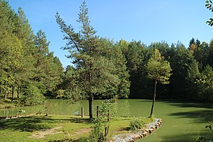
Windorf pond
| Windorf pond | ||
|---|---|---|

|
||
| Island in the middle of the pond | ||
| Geographical location | Kaiserwald , Styria | |
| Drain | Gepringbach → Kainach → Mur | |
| Location close to the shore | Pirka, Windorf | |
| Data | ||
| Coordinates | 46 ° 59 '31 " N , 15 ° 23' 4" E | |
|
|
||
| Altitude above sea level | 358 m above sea level A. | |
| surface | 1.58 ha | |
| length | 550 m | |
| width | 5–80 m | |
| scope | 1.36 km | |
|
particularities |
||
The Windorf pond is an artificial standing water in the northern Kaiserwald in the Austrian state of Styria . The fish pond emerged from an abandoned clay pit of the Wienerberger building materials industry and was designated as a protected part of the landscape in 1988, taking into account its nourishing environment .
Location and surroundings
The elongated water surface lies in an abandoned clay pit in the northern part of the Kaiserwaldterrasse in the municipality of Seiersberg-Pirka . It extends over half a kilometer in a west-east direction parallel to Dorfstrasse, which connects Packer Strasse B 70 with Windorf. The closest villages are Pirka north and Windorf east of the pond. The pond is drained by the Gepringbach , which flows by not far from the western end. While the Kaiserwald directly adjoins the south bank, there are agricultural areas in the north of the pit.
Flora and vegetation
The natural vegetation around the pond Windorfer form black alder - common oak woods are with pine trees , but large areas of spruce - monoculture had to give and receive rudimentary only on the slopes of the pit. The soils consist of agriculturally inferior, pseudo- gleyed dams, which are of Aeolian origin and cover the Quaternary gravel of the Kaiserwald terrace .
After the material had been removed, the clay pit was largely left to its own devices and typical successional vegetation could develop. This created a “deficient biotope”, which represents a biological and ecological enrichment for the surrounding areas. On a ruderal area , a willow border was created with large nettle and land riding grass as frequent representatives. White willow , stinging nettle, marsh bedstraw and various mosses settled in a hollow terrain with a small structure and loose alder and willow trees . Occurrences of coltsfoot have been mapped on the edge of a lily pond . Also, could dewberry , Eleocharis palustris , black alder on small stocks and broadleaf cattail and reed are detected.
Nature and landscape protection
Increasing leisure pressure from anglers and motocross drivers made landscape planning intervention necessary in order to preserve parts of the biotope inventory . The municipality of Pirka therefore expressed several design requests for the area in February 1984, which were ultimately implemented in such a way that the near-natural state was preserved as undisturbed as possible. Both renaturation and recultivation measures came into play. For example, the existing water level was raised with drainage water from the adjacent forests, which reduced the risk of flooding for the village of Windorf. The pond thus also fulfills the function of a flood retention basin . A monk drains the oxygen-poor deep water to control the water quality. On April 13, 1988, the pond and its immediate surroundings with a total area of 6.05 hectares were designated as Protected Landscape Part ( GLT 108 ).
Windorf pond and the immediate vicinity are now a popular local recreation area . The pond is used for sport fishing and ice stick shooting . A natural history trail leads all around , in the middle the water is spanned by a wooden bridge. In 2017, the municipality of Seiersberg-Pirka planned to anchor the Windorf pond in their local development concept as a “priority zone for recreation and sport”, but this was criticized by the Styrian environmental advocate . This step is not compatible with the protective function of the pond as a valuable wet biotope, a retreat for numerous animal and plant species and a valuable part of the landscape, as well as a regulator of the microclimate . The community finally refrained from the planned expulsion.
Web links
Individual evidence
- ↑ Digital Atlas of Styria: Waters & Water Information. State of Styria , accessed April 7, 2019 .
- ^ A b c Norbert Baumann & Arnold Zimmermann: Landscape plan Pirka near Graz. Second hand maintenance and design of a wetland. In: Not. Flora Steiermark 7 , Graz 1985, pp. 15-30. Online PDF , accessed April 6, 2019.
- ↑ Digital Atlas of Styria: Flora & Fauna - Protected Landscape Parts. State of Styria , accessed April 7, 2019 .
- ↑ Ute Pöllinger: Activity report of the environmental attorney January 1 to December 31, 2017. Styrian environmental attorney , Graz 2017, p. 28. Online PDF , accessed on April 6, 2019.
