Xincheng (Hualien)
|
Xincheng 新 城鄉 |
||
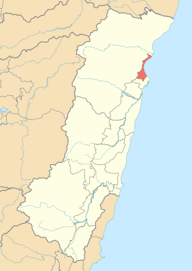
 Location of Xincheng in Hualien County |
||
| State : |
|
|
| County : | Hualien | |
| Coordinates : | 24 ° 2 ' N , 121 ° 37' E | |
| Area : | 29.4095 km² | |
| Residents : | 20,155 (March 2018) | |
| Population density : | 685 inhabitants per km² | |
| Time zone : | UTC + 8 (Chungyuan time) | |
| Telephone code : | (+886) (0) 3 | |
| Postal code : | 971 | |
| ISO 3166-2 : | TW-HUA | |
| Community type : | Rural community ( 鄉 ) | |
| Structure : | 8 villages ( 村 ) | |
| Mayor : | Qian Zili ( 錢 自立 ) ( KMT ) | |
| Website : | ||
|
|
||
Xincheng ( Chinese 新 城鄉 , Pinyin Xīnchéng Xiāng ) is a rural community in Hualien County in the Republic of China, Taiwan .
Location and climate
Xincheng is located on the Pacific coast immediately to the north, adjacent to the district capital Hualien . In the east and north, Xincheng borders on the neighboring community of Xiulin . The municipality has a very elongated shape with a longitudinal extension of about 15 kilometers, as well as a transverse extension of a maximum of 4 kilometers and a minimum of 650 meters. With an area of 29.4 km², Xincheng is the smallest municipality in the district. The municipality is relatively flat, with an altitude of 0 to 200 meters above sea level. From east to northwest, the terrain rises gradually towards the Taiwanese Central Mountains beginning west of the community .
history
The first historically documented human inhabitants of the area were members of the Austronesian indigenous peoples of Taiwan . In the 19th century, under the pressure of the increasing Han-Chinese settlement, a large part of the Kavalan people left the settlement area in the area of the Lanyang plain and settled in the area of today's city of Hualien and the surrounding area. This created an ethnic mix of different peoples in the area - Kavalan, Sakizaya , Amis and Truku . After 1874, in the late phase of the Qing Dynasty , the first one was here Han Chinese settlement in today's Hualien County and founded 'Xincheng' 新城 - called "New City". At the time of the Japanese rule over Taiwan (1895-1945) the settlement was first named Kenkai ( Japanese 研 海 ) and Kenkai Shō (研 海 庄). After Taiwan was handed over to the Republic of China in 1945, the community was given its Chinese name again and was reorganized into a rural community in the newly formed Hualien County.
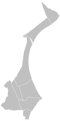
| Outline of Xincheng |
Administrative structure
Xincheng is divided into 8 villages ( 村 , Cūn ). These are Xincheng ( 新城 村 ), Shunan ( 順 安 村 ), Kangle ( 康樂 村 ), Dahan ( 大漢 村 ), Beipu ( 北埔 村 ), Jialin ( 佳 林村 ), Jiali ( 嘉 里 村 ), Jiaxin ( 嘉 新村 ) .
population
In 2018, Xincheng had a population of just over 20,000 and a population density of 685 per km². At the end of 2017, 6515 people (approx. 32%) belonged to the indigenous population. Mostly it concerns Amis, Sakizaya, Truku and Kavalan.
economy
Businesses, trade and administrative authorities are concentrated in the southern part of the municipality, especially in the village of Beipu. Due to its proximity to the city of Hualien, Xincheng is relatively urbanized and economically strongly linked to Hualien. The private Technical University Dahan ( 1977 技術 學院 ) , founded in 1977, is located on site .
Transport links
Provincial road 9 runs parallel to the coast in north-south direction. To the east of this, county road 193 runs largely parallel to it. The north-south connection line ( 北 迴 線 ) of the Taiwanese railroad also runs in north-south direction . In the municipality there are the Xincheng (Taroko) ( 新城 (太魯閣) ) and Beipu ( 北埔 ) stations. Xincheng is also home to Hualien Airport , the second largest airport on the east coast of Taiwan.
Tourist destinations, sights
One tourist destination is Qixingtan Beach 七星潭 海邊 , Qīxīngtán Hǎibiān , which stretches in a large crescent arch along Xincheng Bay.
From 2003 to 2017, the building of a former Japanese fish factory housed the Chihsing Tan Katsuo Museum ( 七星 柴魚 博物館 ), which dealt thematically with fishing and fish processing on the east coast of Taiwan. The cypress wood museum building and its exhibits were largely destroyed by a large fire on July 18, 2017.
Web links
Individual evidence
- ↑ 地理 環境 ("Geographical Environment"). Xincheng Municipality website, accessed May 24, 2018 (Chinese).
- ↑ 人口 族群 ("Population groups"). Xincheng Municipality website, accessed May 24, 2018 (Chinese).
- ↑ a b 行政 中心 ("Administrative Center"). Xincheng Municipality website, accessed May 24, 2018 (Chinese).
- ↑ 原住民 戶數 及 人數 Households and Persons of Indigenous People. (xls) Taiwan Ministry of the Interior, accessed May 19, 2018 (Chinese / English).
- ↑ 交通 網絡 ("Transport connections"). Xincheng Municipality website, accessed May 24, 2018 (Chinese).
- ↑ Qixing Lake (Qixingtan). Taiwan Tourism Office, accessed May 24, 2018 .
- ↑ 全 台 唯一 柴魚 博物館 燒光 光 館 方 : 打斷 手骨 反而 勇. udn.com, accessed May 25, 2018 (Chinese).
- ↑ Chihsing Tan Katsuo Museum Devastated in Early Morning Fire. totaltaipei.com, July 18, 2017, accessed May 24, 2018 .


