Ypäjä
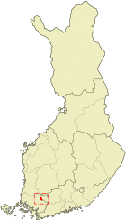
| coat of arms | map |
|---|---|

|

|
| Basic data | |
| State : |
|
| Landscape : | Kanta-malice |
| Administrative community : | Forssa |
| Geographical location | 60 ° 48 ′ N , 23 ° 17 ′ E |
| Surface: | 183.26 km² |
| of which land area: | 182.76 km² |
| of which inland waterways: | 0.50 km² |
| Residents : | 2,357 (Dec 31, 2018) |
| Population density : | 12.9 inhabitants / km² |
| Municipality number : | 981 |
| Language (s) : | Finnish |
| Website : | ypaja.fi |
Ypäjä [ ˈypæjæ ] is a municipality in the Finnish region of Häme with 2357 inhabitants (as of December 31, 2018). It is located in the west of the Kanta-Häme landscape on the banks of the Loimijoki River between the towns of Forssa (23 km east) and Loimaa (15 km west).
The Ypäjä area has been inhabited since the 12th century. The actual development of the place did not begin until the end of the 19th century, after the railway line from Turku to Toijala was completed in 1876. Ypäjä station opened in 1888, but no trains have stopped there since 1984. The church of Ypäjä dates from 1901 and replaces a previous wooden building from 1799. The parish center of Ypäjä is the parish of Ypäjä with the name Perttula. In addition, the municipal area includes the villages Levä, Ypäjänkylä, Kuusjoki, Manninen, Palikkala and Varsanoja.
Horse breeding has been a tradition in Ypäjä ever since the Finnish Army's horse depot was established here in 1931 . Today Ypäjä describes itself as a "horse community".
Sons and daughters
- Uno Holmberg-Harva (1882–1949), theologian, religious historian, ethnographer, ethnosociologist and folklorist
Web links
swell
- ↑ Maanmittauslaitos (Finnish land surveying office): Suomen pinta-alat kunnittain January 1, 2010 . (PDF; 199 kB)
- ↑ Statistical Office Finland: Table 11ra - Key figures on population by region, 1990-2018