
Forssa
| coat of arms | map |
|---|---|

|

|
| Basic data | |
| State : |
|
| Landscape : | Kanta-malice |
| Administrative community : | Forssa |
| Geographical location | 60 ° 49 ′ N , 23 ° 38 ′ E |
| Surface: | 253.39 km² |
| of which land area: | 248.78 km² |
| of which inland waterways: | 4.61 km² |
| Residents : | 17,028 (Dec. 31, 2018) |
| Population density : | 68.4 inhabitants / km² |
| Municipality number : | 061 |
| Language (s) : | Finnish |
| Website : | forssa.fi |
Forssa [ ˈfɔrsːɑ ] is an industrial city in the Finnish region of Häme with 17,028 inhabitants (as of December 31, 2018).
location
Forssa is located in the western part of the landscape Tavastia riverside Loimijoki . The neighboring municipalities of Forssa are Tammela in the southeast, Jokioinen and Humppila in the west and Urjala in the north. The city is the center of the administrative community of the same name ( seutukunta ) ; many residents of neighboring communities commute to work in Forssa. Forssa is located in the densely populated triangle between the southern Finnish cities of Helsinki , Turku and Tampere . The next larger city is Hämeenlinna 56 kilometers east, the distance to the capital Helsinki is around 110 kilometers.
The actual city of Forssa consists of the districts Haudankorva, Järvenpää, Kaikula, Keskusta, Kalliomäki, Korkeavaha, Kuhala, Kuusto, Lamminranta, Linikkala, Ojalanmäki, Paavola, Pikku-Muolaa, Pisbergäs, Völöik, Talso and Talso. In addition, the municipal area of 254.6 square kilometers includes part of the rural area with the villages of Koijärvi and Matku as well as the villages of Ahoniitty, Haisio, Ilvesoja, Järvenpää, Kojo, Lunttila, Vuolle, Lempää, Rekirikko, Kukkapää, Vuoltuiemialsu, Savitooiniem and Suonpää.
Forssa was created when the Swedish manufacturer Axel Wilhelm Wahren founded a spinning mill on a rapids on the Loimijoki in 1847. In the years that followed, a densely populated village developed around the factory. Until the 1970s, the textile industry was the most important branch of the economy in Forssa. The place, strongly influenced by industry, was one of the strongholds of the Finnish labor movement: at its party congress in Forssa in 1903, the Finnish Labor Party adopted its new program and adopted the current name of the Social Democratic Party of Finland . In 1923 Forssa was detached from the community of Tammela and raised to an independent market town. In 1964 Forssa finally became a town, which in 1969 expanded again with the incorporation of Koijärvi.
Today, in addition to the textile industry, food production and printing are important branches of industry in Forssa. The largest company based in the city is the food producer HK Ruokatalo . The Finnish economic crisis in the early 1990s was a severe blow to Forssa's development. Since then, the city's population, which was over 20,000 in the 1980s, has been falling steadily.
traffic
The city was the end of the Jokioinen – Forssa railway , a narrow-gauge railway line from which a 14 km long remnant from Humppila to Jokioinen is operated as a museum railway by Jokioisten Museorautatie . In Forssa, from 1899 to 1973, the railway line was connected to an industrial railway electrified with 500 V, which supplied numerous industrial companies in the city with the same gauge.
sons and daughters of the town
- Esko Aaltonen (1893–1966), sociologist and folklorist
- Pentti Niinivuori (1931-1988), boxer
- Kalevi Aho (* 1949), composer
- Petri Kujala (* 1970), ice hockey player
- Anita Hakala (* 1971), cross-country skier and biathlete
- Johanna Paasikangas-Tella (* 1974), chess player
- Sanni Grahn-Laasonen (* 1983), politician
- Roosa Koskelo (* 1991), volleyball player
- Juuse Saros (* 1995), ice hockey goalkeeper
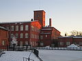
The historical Forssa spinning mill
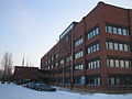
Forssa town hall
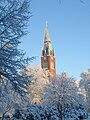
The Forssa Church, designed by Josef Stenbäck , was built in 1914–1917.


Individual evidence
- ↑ Maanmittauslaitos (Finnish land surveying office): Suomen pinta-alat kunnittain January 1, 2010 (PDF file; 194 kB)
- ↑ Statistical Office Finland: Table 11ra - Key figures on population by region, 1990-2018
Web links
- City of Forssa ( Finnish , Swedish , English )