
Urjala
| coat of arms | map |
|---|---|

|

|
| Basic data | |
| State : |
|
| Landscape : | Pirkanmaa |
| Administrative community : | South Pirkanmaa |
| Geographical location | 61 ° 5 ' N , 23 ° 32' E |
| Surface: | 505.39 km² |
| of which land area: | 475.08 km² |
| of which inland waterways: | 30.31 km² |
| Residents : | 4,792 (Dec 31, 2018) |
| Population density : | 10.1 inhabitants / km² |
| Municipality number : | 887 |
| Language (s) : | Finnish |
| Website : | urjala.fi |
Urjala ( Swedish : Urdiala) is a municipality in the Pirkanmaa countryside in western Finland .
Localities
The communities include Annula, Brusila, Haaronen, Hakkila, Hakolahti, Halkivaha, Harittu, Hautaa, Honkola, Huhti, Ikaala, Järviö, Kamppari, Kankaanpää, Kehro, Kokko, Kinola, Kiimankulma, Laukeela, Matku, Mellola, Nuutajärvi, Pappila, Perho, Puolimatka, Salmi, Taipale, Tursa, Urjalankylä, Uusi-Salmi, Vahonen, Valajärvi and Velkala.
Community partnerships
Urjala maintains the following partnerships :
- Sæby ( Denmark )
- Serpukhov ( Russia ), since 1964
- Tranås ( Sweden ), since 1980
- Stavern ( Norway ), since 1985
- Narva ( Estonia ), since 1989
Sons and daughters of the church
- Väinö Linna (1920–1992), writer
photos
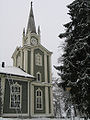
Urjala Church

Medieval sacristy in Urjala
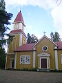
Halkivaha Church
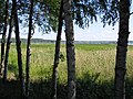
Lake Kortejärvi in Urjala


Web links
Commons : Urjala - collection of images, videos and audio files
Individual evidence
- ↑ Maanmittauslaitos (Finnish land surveying office): Suomen pinta-alat kunnittain January 1, 2010 (PDF; 199 kB)
- ↑ Statistical Office Finland: Table 11ra - Key figures on population by region, 1990-2018