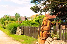
Zbožice
| Zbožice | ||||
|---|---|---|---|---|
|
||||
| Basic data | ||||
| State : |
|
|||
| Region : | Kraj Vysočina | |||
| District : | Havlíčkův Brod | |||
| Municipality : | Havlíčkův Brod | |||
| Area : | 255 ha | |||
| Geographic location : | 49 ° 39 ' N , 15 ° 34' E | |||
| Height: | 545 m nm | |||
| Residents : | 44 (2011) | |||
| Postal code : | 580 01 | |||
| License plate : | J | |||
| traffic | ||||
| Street: | Rozňák - Zbožice | |||
Zbožice (German Zboschitz , also Sboschitz ) is a district of the city Havlíčkův Brod in the Czech Republic . It is located six kilometers north of the city center of Havlíčkův Brod and belongs to the Okres Havlíčkův Brod .
geography
Zbožice is located on a ridge between the valleys of the Rozkošský potok and Cihlářský potok in the Hornosázavská pahorkatina ( hill country on the upper Sázava ). To the north rises the Volský vrch ( Ochsenberg , 598 m nm), in the northeast of the Trčolec (high mountain , 573 m nm) and northwest of the Na Skalce (573 m nm). State road I / 38 runs west of the village between Havlíčkův Brod and Habry .
Neighboring towns are Olešná and Kráty in the north, Horní Krupá in the northeast, Karlov and Dolní Krupá in the east, Chrast and Knyk in the southeast, Rozňák and Pelestrov in the south, Veselý Žďár and Valečov in the southwest, Chlum and Radostín in the west and Červený Důl and Skuhrov in the Northwest.
history
The first written mention of the village took place in 1445. Zbožice belonged to the goods of the town of Deutschbrod for centuries . In 1787 there were nine houses in Zbožicz .
In 1840 the village of Zbožitz in the Caslauer Kreis consisted of eleven houses in which 73 people lived. The parish was Unter-Kraupen . Until the middle of the 19th century, Zbožitz remained subordinate to the royal city of Teutschbrod.
After the abolition of patrimonial formed Zbožice 1849 a district of the municipality Knyk in the judicial district Deutschbrod . From 1868 the village belonged to the Deutschbrod district . In 1869 Zbožice had 94 inhabitants and consisted of 13 houses. In 1900 there were 113 people in Zbožice, compared to 90 in 1910. The road from Rozňák to Zbožice was completed in 1920. From 1920 the village sought to separate from the municipality of Knyk and finally became independent in the 1920s. In 1930 Zbožice had 107 inhabitants and consisted of 20 houses. In 1961 Zbožice was again incorporated into Knyk. On April 30, 1976 the forced incorporation of Knyk with its districts to Havlíčkův Brod took place . After the Velvet Revolution in 1989, the residents of Zbožice decided in a referendum to stay with the town of Havlíčkův Brod, while in Knyk and Rozňák the decision was made to separate. On November 24, 1990, the Knyk parish was re-established; the district of Zbožice has been an exclave of the urban area of Havlíčkův Brod since then. In the 2001 census, 59 people lived in the 26 houses in Zbožice.
Local division
The district of Zbožice forms a cadastral district.
Attractions
- Floor cross on the road to Horní Krupá
literature
- Historický lexikon obcí České republiky 1869–2005 , part 1, p. 552
Web links
Individual evidence
- ↑ http://www.uir.cz/katastralni-uzemi/667234/Zbozice
- ↑ Jaroslaus Schaller : Topography of the Kingdom of Bohemia. Sixth part. Czaslauer Kreis Prague and Vienna 1787, p. 159
- ^ Johann Gottfried Sommer : The Kingdom of Bohemia; Represented statistically and topographically. Volume 11: Caslauer Kreis. Ehrlich, Prague 1843, p. 190.
- ↑ http://www.uir.cz/katastralni-uzemi/667234/Zbozice


