Zschorno
|
Zschorno
Jämlitz-Klein Düben municipality
Coordinates: 51 ° 34 ′ 37 ″ N , 14 ° 40 ′ 7 ″ E
|
|
|---|---|
| Height : | 122 m above sea level NHN |
| Incorporation : | July 1, 1950 |
| Incorporated into: | Jämlitz |
| Postal code : | 03130 |
| Area code : | 035771 |
|
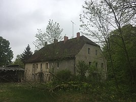
Manor house in Zschorno
|
|
Zschorno ( Lower Sorbian Carna ) is an inhabited part of the municipality Jämlitz-Klein Düben of the Döbern-Land department in the Spree-Neisse district in Brandenburg . Until October 18, 1937, the place was called Tzschorne and then, as part of the National Socialist Germanization of Sorbian place names, until 1945 Hirschwinkel .
geography
The place is located 2 kilometers northeast of Jämlitz , 5 kilometers northeast of Klein Düben , 7 kilometers southeast of Döbern and 18 kilometers south-southeast of Forst (Lausitz) . The neighboring towns are Jerischke and Teichhäuser in the northeast, Köbeln and Bad Muskau in the southeast, Alte Schänke, Jämlitz, Weißmühle and Hermannsmühle in the southwest, Tschernitz in the west and Eichwege in the northwest.
history
The first documentary mention of the place comes from a document from May 4, 1524. It is recorded with the name Tzornau . At that time Zschorno was a Vassallendorf of the noble lords of Bieberstein .
literature
- Historical local lexicon for Niederlausitz - Volume 2 - The districts of Cottbus, Spremberg, Guben and Sorau . Edited by Rudolf Lehmann. In: Publications of the Brandenburg State Main Archive (Potsdam State Archive) . Publishing house Klaus-D. Becker, Potsdam 2011, ISBN 978-3-941919-90-7 , pp. 437 f .
Web links
- Zschorno in the Genealogical Directory of Places
Individual evidence
- ^ Entry "Carna" in the Lower Sorbian place name database on dolnoserbski.de
- ↑ Jämlitz-Klein Düben municipality - districts according to § 45 municipal constitution - inhabited parts of the municipality - living spaces. In: service.brandenburg.de. Ministry of the Interior and Local Affairs of the State of Brandenburg, accessed on October 15, 2016 .
- ↑ a b Historical local lexicon for Niederlausitz - Volume 2 - The districts of Cottbus, Spremberg, Guben and Sorau. 2011, p. 437.
- ^ Michael Rademacher: German administrative history from the unification of the empire in 1871 to the reunification in 1990. Sorau district (Lausitz). (Online material for the dissertation, Osnabrück 2006).
- ↑ BrandenburgViewer of the state survey and geographic base information Brandenburg (LGB)
