Zaorejas: Difference between revisions
Content deleted Content added
No edit summary |
Citation bot (talk | contribs) Alter: title. | Use this bot. Report bugs. | Suggested by BrownHairedGirl | #UCB_webform 1487/2008 |
||
| (14 intermediate revisions by 5 users not shown) | |||
| Line 1: | Line 1: | ||
{{Infobox settlement |
{{Infobox settlement |
||
official_name = Zaorejas, Spain |
| official_name = Zaorejas, Spain |
||
nickname = |
| nickname = |
||
image_flag = |
| image_flag = |
||
image_seal = Escudo de Zaorejas.svg |
| image_seal = Escudo de Zaorejas.svg |
||
image_skyline = El Campillo calcareous tufa - Zaorejas, Guadalajara, Spain.JPG |
| image_skyline = El Campillo calcareous tufa - Zaorejas, Guadalajara, Spain.JPG |
||
map_caption = |
| map_caption = |
||
pushpin_map = Spain |
| pushpin_map = Spain Province of Guadalajara#Spain Castilla-La Mancha#Spain |
||
pushpin_map_caption = Location in Spain |
| pushpin_map_caption = Location in Spain |
||
pushpin_label = Zaorejas |
| pushpin_label = Zaorejas |
||
subdivision_type = [[List of sovereign states|Country]] |
| subdivision_type = [[List of sovereign states|Country]] |
||
subdivision_name = {{flag|Spain}} |
| subdivision_name = {{flag|Spain}} |
||
subdivision_type1 = [[Autonomous communities of Spain|Autonomous community]] |
| subdivision_type1 = [[Autonomous communities of Spain|Autonomous community]] |
||
subdivision_name1 = [[Castile-La Mancha]] |
| subdivision_name1 = [[Castile-La Mancha]] |
||
subdivision_type2 = [[Provinces of Spain|Province]] |
| subdivision_type2 = [[Provinces of Spain|Province]] |
||
subdivision_name2 = [[Guadalajara (province)|Guadalajara]] |
| subdivision_name2 = [[Guadalajara (province)|Guadalajara]] |
||
subdivision_type3 = [[List of municipalities in Guadalajara|Municipality]] |
| subdivision_type3 = [[List of municipalities in Guadalajara|Municipality]] |
||
subdivision_name3 = Zaorejas |
| subdivision_name3 = Zaorejas |
||
leader_title = |
| leader_title = |
||
leader_name = |
| leader_name = |
||
area_magnitude = |
| area_magnitude = |
||
area_total_km2 = |
| area_total_km2 = 189 |
||
area_land_km2 = |
| area_land_km2 = |
||
area_water_km2 = |
| area_water_km2 = |
||
elevation_m = |
| elevation_m = 1225 |
||
| ⚫ | |||
population_as_of = 2015 | |
|||
| population_as_of = {{Spain metadata Wikidata|population_as_of}} |
|||
| ⚫ | |||
| population_footnotes = {{Spain metadata Wikidata|population_footnotes}} |
|||
population_total = 139 | |
|||
| population_total = {{Spain metadata Wikidata|population_total}} |
|||
population_density_km2 = auto |
| population_density_km2 = auto |
||
timezone = [[Central European Time|CET]] |
| timezone = [[Central European Time|CET]] |
||
utc_offset = +1 |
| utc_offset = +1 |
||
timezone_DST = [[Central European Summer Time|CEST]] |
| timezone_DST = [[Central European Summer Time|CEST]] |
||
utc_offset_DST = +2 |
| utc_offset_DST = +2 |
||
|coordinates = {{coord|40|45|44|N|2|12|4|W|region:ES|display=inline,title}} |
|coordinates = {{coord|40|45|44|N|2|12|4|W|region:ES|display=inline,title}} |
||
| ⚫ | |||
| |
|||
| ⚫ | |||
| ⚫ | |||
| ⚫ | |||
| ⚫ | |||
| ⚫ | |||
| ⚫ | |||
| ⚫ | |||
'''Zaorejas''' is a municipality located in the [[Guadalajara (province)|province of Guadalajara]], [[Castile-La Mancha]], Spain. According to the 2004 [[census]] ([[Instituto Nacional de Estadística (Spain)|INE]]), the municipality had a population of 197 inhabitants. |
'''Zaorejas''' is a municipality located in the [[Guadalajara (province)|province of Guadalajara]], [[Castile-La Mancha]], Spain. According to the 2004 [[census]] ([[Instituto Nacional de Estadística (Spain)|INE]]), the municipality had a population of 197 inhabitants. |
||
There are remains of a [[Roman Aqueduct of Zaorejas|Roman aqueduct]] in the village. |
|||
Two other settlements, [[Huertapelayo]] and [[Villar de Cobeta]], are part of the municipality. |
|||
==References== |
==References== |
||
| Line 46: | Line 50: | ||
{{Municipalities in Guadalajara}} |
{{Municipalities in Guadalajara}} |
||
| ⚫ | |||
[[Category:Populated places in the Province of Guadalajara]] |
|||
{{authority control}} |
|||
| ⚫ | |||
{{CastileLaMancha-geo-stub}} |
{{CastileLaMancha-geo-stub}} |
||
Latest revision as of 12:44, 20 August 2022
Zaorejas, Spain | |
|---|---|
 | |
| Coordinates: 40°45′44″N 2°12′4″W / 40.76222°N 2.20111°W[1] | |
| Country | |
| Autonomous community | Castile-La Mancha |
| Province | Guadalajara |
| Municipality | Zaorejas |
| Area | |
| • Total | 189 km2 (73 sq mi) |
| Elevation | 1,225 m (4,019 ft) |
| Population (2018)[2] | |
| • Total | 125 |
| • Density | 0.66/km2 (1.7/sq mi) |
| Time zone | UTC+1 (CET) |
| • Summer (DST) | UTC+2 (CEST) |
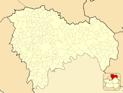
Zaorejas is a municipality located in the province of Guadalajara, Castile-La Mancha, Spain. According to the 2004 census (INE), the municipality had a population of 197 inhabitants.
There are remains of a Roman aqueduct in the village.
Two other settlements, Huertapelayo and Villar de Cobeta, are part of the municipality.
References[edit]
- ^ "NGA: (WWW) Geonames Search - OGC Viewer WWW". Archived from the original on October 3, 2011. Retrieved November 7, 2011.
- ^ Municipal Register of Spain 2018. National Statistics Institute.


