Albalate de Zorita
| Municipality of Albalate de Zorita | ||
|---|---|---|
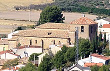
 Albalate de Zorita - town view
|
||
| coat of arms | Map of Spain | |

|
|
|
| Basic data | ||
| Autonomous Community : |
|
|
| Province : | Guadalajara | |
| Comarca : | La Alcarria | |
| Coordinates | 40 ° 19 ′ N , 2 ° 51 ′ W | |
| Height : | 760 msnm | |
| Area : | 53.32 km² | |
| Residents : | 943 (Jan. 1, 2019) | |
| Population density : | 17.69 inhabitants / km² | |
| Postal code : | 19208 | |
| Municipality number ( INE ): | 19006 | |
| administration | ||
| Website : | Albalate de Zorita | |
Albalate de Zorita is a place and a Spanish municipality ( municipio ) with 943 inhabitants (as of January 1, 2019) in the province of Guadalajara in the autonomous region of Castile-La Mancha . The municipality belongs to the sparsely populated region of the Serranía Celtibérica .
Location and climate
Almonacid de Zorita is located almost 760 m above sea level in the south of the Alcarria landscape in the north of the southern part of the Iberian plateau ( meseta ) . The provincial capital Guadalajara is a good 60 km (driving distance) in a north-westerly direction; the lovely town of Pastrana is a good 16 km north-west. The climate in winter is temperate, while in summer it is warm to hot; the rather low amounts of precipitation (approx. 435 mm / year) fall - with the exception of the almost rainless summer months - distributed over the whole year.
Population development
| year | 1857 | 1900 | 1950 | 2000 | 2019 |
| Residents | 845 | 980 | 1,377 | 910 | 943 |
As a result of the mechanization of agriculture , the abandonment of small farms and the resulting loss of jobs, the population of the municipality has decreased significantly since the middle of the 20th century ( rural exodus ). The community also includes the new district of Nueva Sierra de Altomira with around 200 inhabitants .
economy
The people of earlier centuries lived mainly as self-sufficiency from agriculture and livestock farming , whose durable products (cheese, sausage, animal skins and wool) could be exchanged or sold at traveling traders.
history
Albalate de Zorita is a place of Arabic origin (Al-balate = "way"). In 1085 the area was occupied by the troops of King Alfonso VI. Recaptured by León ( reconquista ) and then repopulated ( repoblación ) with Christians from all parts of the Iberian Peninsula . In 1175 King Alfonso VIII of Castile handed the place into the hands of the Order of Calatrava . In the 16th century he came under the rule of the Prince of Éboli and his wife Ana de Mendoza y de la Cerda , whose descendants resided there until the 19th century.
Attractions
- The three-aisled Iglesia de San Andrés was built in the late 15th and early 16th centuries. The north portal shows a late Gothic - Isabelline decor; the interior is designed as a hall church with star vaults . The font dates from 1545; the churrigueresque main altar with its Solomonic columns is a work of the years 1703–1707. The church's greatest treasure is a golden crucifix from the 13th century that is almost 50 cm high and 28 cm wide .
- The Ermita de Nuestra Señora de los Remedios was built in the years 1655–1676.
- The Fuente de los Canos 13 is a first time mentioned wide mounted in 1557 wells, the same time as a cattle trough (Abrevadero) served. During a redesign in the 17th century, the number of pipes was reduced from the original 13 to just 8.
- Surroundings
- The late Romanesque Ermita de Cubillas , located at the cemetery (cemeterio) approx. 1 km southwest of the village, has two short pointed arched stepped portals with decoration.
Web links
Individual evidence
- ↑ Cifras oficiales de población resultantes de la revisión del Padrón municipal a 1 de enero . Population statistics from the Instituto Nacional de Estadística (population update).
- ↑ Albalate de Zorita - climate tables
- ^ Albalate de Zorita - population development
- ↑ Albalate de Zorita - Church
- ↑ Albalate de Zorita - Ermita de Remedios
- ↑ Albalate de Zorita - Fountain
- ↑ Albalate de Zorita - Ermita de Cubillas

