
Anguita (Guadalajara)
| Anguita municipality | |||
|---|---|---|---|
 Anguita - Barrio Hoz
|
|||
| coat of arms | Map of Spain | ||

|
|
||
| Basic data | |||
| Autonomous Community : |
|
||
| Province : | Guadalajara | ||
| Comarca : | Serranía de Guadalajara | ||
| Coordinates | 41 ° 2 ′ N , 2 ° 22 ′ W | ||
| Height : | 1125 msnm | ||
| Area : | 127.22 km² | ||
| Residents : | 156 (Jan 1, 2019) | ||
| Population density : | 1.23 inhabitants / km² | ||
| Postal code : | 19283 | ||
| Municipality number ( INE ): | 19032 | ||
| administration | |||
| Website : | Anguita | ||

Anguita called a location and several hamlets (Pedanías) existing municipality ( municipio ) with 156 inhabitants (at January 1, 2019) in the northeast of the province of Guadalajara in the Autonomous Community of Castile-La Mancha . The Catholic parish belongs to the diocese of Sigüenza-Guadalajara . Anguita is on the Camino del Cid .
Location and climate
The place Anguita is located on the Río Tajuña in the mountainous northeast of the province of Guadalajara near the border with the province of Soria at an altitude of about 1125 m . The distance to the southwestern provincial capital Guadalajara is approx. 87 km (driving distance). The city of Sigüenza is about 28 km to the west; the small but historically and culturally significant place Medinaceli is only about 26 km to the north. The climate is temperate to warm; Rain (approx. 515 mm / year) falls over the year.
Population development
| year | 1857 | 1900 | 1950 | 2000 | 2017 |
| Residents | 707 | 930 | 708 | 275 | 176 |
The increasing mechanization of agriculture as well as the abandonment of small farms and the resulting loss of jobs led to a significant decline in the population in the second half of the 20th century, even through the incorporation of the formerly independent villages of Aguilar de Anguita, Santa María del Espino, Padilla del Ducado and Villarejo de Medina could not be caught.
economy
For centuries the community lived exclusively from growing grain ( barley and wheat ), which was mainly operated for self-sufficiency ; livestock farming (sheep, goats, chickens) also took place to a small extent. The place Anguita served as a mercantile, craft and cultural center for the hamlets and farmsteads in its area, which have since mostly disappeared. Today agriculture still plays the most important role, but there is also income from tourism (rental of holiday homes).
history
Two Celtiberian fortresses (castra) have been uncovered in the municipality ; however, neither Roman nor Visigoth traces were discovered. After the Arab-Moorish conquest , large areas in the north of the Iberian Peninsula were depopulated , which began in the 10th century and in the second half of the 11th century under Alfonso VI. Complete reconquest ( reconquista ) of New Castile , which reached its preliminary climax in 1085 with the capture of the city of Toledo, about 200 km further south-west, and was repopulated ( repoblación ) . In the high Middle Ages the region belonged to the Villa y Tierra de Medinaceli ; During this time, the population of the city of Medinaceli and the surrounding areas was excommunicated because they refused to contribute to the cost of building the new cathedral in Sigüenza .
Attractions

- Anguita
- The remains of two Celtiberian castra can be found in the vicinity of the village . The richly decorated breastplate made of bronze in the form of a round shield with attached leg protection was also found here, which is now in the Museo Arqueológico Nacional in Madrid .
- The medieval “stork tower ” (Torre de la Cigüeña) is the town's landmark. Immediately next to it are the approximately two meter high foundation walls of a watchtower ( atalaya ) .
- The parish church ( Iglesia de San Pedro ) has both Romanesque and Gothic parts.
- The portal facade of a late medieval hospital is in the center of the village.
- Two hermit churches (Ermita de Nuestra Señora de la Lastra and Ermita de la Soledad) enrich the townscape.
- Aguilar de Anguita
- In the vicinity of the village are the remains of a small bridge that, according to local tradition, dates back to Roman times.

Celtiberian bronze breastplate
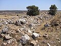
Castrum of La Cerca

Necropolis of Portillo

Roman bridge

Ermita de Nuestra Señora de la Lastra
_01.jpg)

.jpg)


literature
- Javier Serrano Copete: Una historia de Anguita: el pueblo y su entorno. AACHE Ediciones, Guadalajara 2008, ISBN 978-84-96885-50-9 .
Web links
- Anguita, Castro Celtibérico de Hocincavero - information (Wikipedia, Spanish)
- Anguita, Castro Celtibérico de La Cerca - Photo + Info (Spanish)
- Anguita Photos
- Anguita - photos + info (spanish)
Individual evidence
- ↑ Cifras oficiales de población resultantes de la revisión del Padrón municipal a 1 de enero . Population statistics from the Instituto Nacional de Estadística (population update).
- ↑ Anguita - climate tables
- ^ Anguita - population development
Abánades | Ablanque | Adobes | Alaminos | Alarilla | Albalate de Zorita | Albaren | Albendiego | Alcocer | Alcolea de las Peñas | Alcolea del Pinar | Alcoroches | Aldeanueva de Guadalajara | Algar de Mesa | Algora | Alhóndiga | Alique | Almadrones | Almoguera | Almonacid de Zorita | Alocén | Alovera | Alustante | Angón | Anguita | Anquela del Ducado | Anquela del Pedregal | Aranzueque | Arbancón | Arbeteta | Argecilla | Armallones | Armuña de Tajuña | Arroyo de las Fraguas | Atanzón | Atienza | Auñón | Azuqueca de Henares | Baides | Baños de Tajo | Bañuelos | Barriopedro | Berninches | La Bodera | Brihuega | Budia | Bujalaro | Bustares | Cabanillas del Campo | Campillo de Dueñas | Campillo de Ranas | Campisábalos | Canredondo | Cantalojas | Cañizar | El Cardoso de la Sierra | Casa de Uceda | El Casar | Casas de San Galindo | Caspueñas | Castejón de Henares | Castellar de la Muela | Castilforte | Castilnuevo | Cendejas de Enmedio | Cendejas de la Torre | Centenera | Checa | Chequilla | Chiloeches | Chillarón del Rey | Cifuentes | Cincovillas | Ciruelas | Ciruelos del Pinar | Cobeta | Cogollor | Cogolludo | Condemios de Abajo | Condemios de Arriba | Congostrina | Copernal | Corduente | El Cubillo de Uceda | Driebes | Durón | Embid | Escamilla | Escariche | Escopete | Espinosa de Henares | Esplegares | Establés | Estriégana | Fontanar | Fuembellida | Fuencemillán | Fuentelahiguera de Albatages | Fuentelencina | Fuentelsaz | Fuentelviejo | Fuentenovilla | Gajanejos | Galápagos | Galve de Sorbe | Gárgoles de Abajo | Gárgoles de Arriba | Gascueña de Bornova | Guadalajara | Henche | Heras de Ayuso | Herrería | Hiendelaencina | Hijes | Hita | Hombrados | Hontoba | Listen | Hortezuela de Océn | La Huerce | Huérmeces del Cerro | Huertahernando | Hueva | Humane | Illana | Iniéstola | Las Inviernas | Irueste | Jadraque | Jirueque | Ledanca | Loranca de Tajuña | Lupiana | Luzaga | Luzón | Majaelrayo | Málaga del Fresno | Malaguilla | Mandayona | Mantiel | Maranchón | Marchamalo | Masegoso de Tajuña | Matarrubia | Matillas | Mazarete | Mazuecos | Medranda | Megina | Membrillera | Miedes de Atienza | La Mierla | Milmarcos | Millana | La Miñosa | Mirabueno | Miralrío | Mochales | Mohernando | Molina de Aragón | Monasterio | Mondéjar | Montarrón | Moratilla de los Meleros | Morenilla | Muduex | Las Navas de Jadraque | Negrodo | Ocentejo | El Olivar | Olmeda de Cobeta | La Olmeda de Jadraque | El Ordial | Orea | Pálmaces de Jadraque | Pardos | Paredes de Sigüenza | Pareja | Pastrana | El Pedregal | Peñalén | Peñalver | Peralejos de las Truchas | Peralveche | Pinilla de Jadraque | Pinilla de Molina | Pioz | Piqueras | El Pobo de Dueñas | Poveda de la Sierra | Pozo de Almoguera | Pozo de Guadalajara | Prádena de Atienza | Prados Redondos | Puebla de Beleña | Puebla de Valles | Cross | Rebollosa de Jadraque | El Recuenco | Renera | Retiendas | Riba de Saelices | Rillo de Gallo | Riofrío del Llano | Robledillo de Mohernando | Robledo de Corpes | Romanillos de Atienza | Romanones | Rueda de la Sierra | Sacecorbo | Sacedón | Saelices de la Sal | Salmerón | San Andrés del Congosto | San Andrés del Rey | Santiuste | Saúca | Sayatón | Selas | Semillas | Setiles | Sienes | Sigüenza | Solanillos del Extremo | Somolinos | El Sotillo | Sotodosos | Tamajón | Taragudo | Taravilla | Tartanedo | Tendilla | Terzaga | Tierzo | La Toba | Tordelrábano | Tordellego | Gate silos | Torija | Torre del Burgo | Torrecuadrada de Molina | Torrecuadradilla | Torrejón del Rey | Torremocha de Jadraque | Torremocha del Campo | Torremocha del Pinar | Torremochuela | Torrubia | Tórtola de Henares | Tortuera | Tortuero | Traíd | Trijueque | Trillo | Uceda | Ujados | Usanos | Utande | Valdarachas | Valdearenas | Valdeavellano | Valdeaveruelo | Valdeconcha | Valdegrudas | Valdelcubo | Valdenuño Fernández | Valdepeñas de la Sierra | Valderrebollo | Valdesotos | Valfermoso de Tajuña | Valhermoso | Valtablado del Río | Valverde de los Arroyos | Viana de Jadraque | Villaescusa de Palositos | Villanueva de Alcorón | Villanueva de Argecilla | Villanueva de la Torre | Villares de Jadraque | Villaseca de Henares | Villaseca de Uceda | Villel de Mesa | Viñuelas | Yebes | Yebra | Yélamos de Abajo | Yélamos de Arriba | Yunquera de Henares | La Yunta | Zaorejas | Zarzuela de Jadraque | Zorita de los Canes