Trijueque
| Trijueque municipality | ||
|---|---|---|
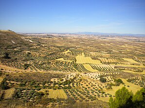
 Landscape near Trijueque
|
||
| coat of arms | Map of Spain | |

|
|
|
| Basic data | ||
| Autonomous Community : | Castile-La Mancha | |
| Province : | Guadalajara | |
| Comarca : | La Alcarria | |
| Coordinates | 40 ° 47 ′ N , 3 ° 0 ′ W | |
| Height : | 995 msnm | |
| Area : | 35.63 km² | |
| Residents : | 1.201 (Jan. 1, 2019) | |
| Population density : | 33.71 inhabitants / km² | |
| Postal code : | 19192 | |
| Municipality number ( INE ): | 19290 | |
| administration | ||
| Website : | Trijueque | |
Trijueque is a central Spanish city and a municipality ( municipio ) with a total of 1,201 inhabitants (as of January 1 2019) in the province of Guadalajara in the autonomous region of Castile-La Mancha . The municipality belongs to the sparsely populated region of the Serranía Celtibérica .
Location and climate
The village of Trijueque, which is almost 1000 m high, is on the west side of the Iberian Mountains . The provincial capital Guadalajara is approx. 23 km (driving distance) in a southwest direction. The climate in winter is temperate, while in summer it is warm to hot; the rather low amounts of precipitation (approx. 475 mm / year) fall - with the exception of the almost rainless summer months - distributed over the whole year.
Population development
| year | 1857 | 1900 | 1950 | 2000 | 2019 |
| Residents | 789 | 690 | 533 | 465 | 1,201 |
Due to the mechanization of agriculture , the abandonment of small farms and the resulting loss of jobs, the population of the municipality would have declined sharply since the middle of the 20th century ( rural exodus ) if the first section of the Autovía A, which passed directly by the village, were not in 1990 -2 ( Madrid - Saragossa ) opened; As a result, several companies settled in and created new jobs.
economy
Agriculture was only possible to a limited extent in the largely flat but dry landscape; one therefore devoted itself primarily to the planting of vines and olive trees, which determine the landscape.
history
The origins of the place are in the dark; Celtic - Iberian Roman , Visigoth and even Moorish traces are missing. Possibly the place emerged only in the phase of repopulation ( repoblación ) after the reconquest ( reconquista ) of the areas south of the Duero in the years between 1031 and 1085. Alfonso VI. von León incorporated the place into the Comúnidad de la Villa y Tierra de Hita . Around the middle of the 15th century the place belonged to the manor (señorio) of Iñigo López de Mendoza from the house of Mendoza , which lasted until the abolition of all manors in the first half of the 19th century.
Attractions
- The most important attraction of the place is the Plaza Mayor with the town hall (ayuntamiento) , a building from the 16th century with the stone coats of arms of the house of Mendoza and the Spanish crown.
- The Iglesia de la Asunción , which stands on the western edge of the town and was built in the 16th century from quarry stones (mampostería) , but largely collapsed a long time ago, has a rather simple south portal in the Renaissance style .
- An approximately 15 m high tower (torreon) was part of the city fortifications. The approximately 2.50 m high entrance could only be reached via a ladder.
- Surroundings
- The 17th century Ermita de Soledad on the other side of the motorway has a two-part portal.
- In the vineyards there are still several stone huts as shelters for the field guards.
Personalities
- Miguel López de la Serna , Franciscan, Bishop of the Canary Islands from 1486 to 1490
Web links
Individual evidence
- ↑ Cifras oficiales de población resultantes de la revisión del Padrón municipal a 1 de enero . Population statistics from the Instituto Nacional de Estadística (population update).
- ↑ Trijueque - climate tables
- ↑ Trijueque - population development
