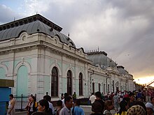
Äiteke Bi (Qysylorda)
| Basic data | ||
|---|---|---|
| State : |
|
|
| Territory : | Kyzylorda | |
| Audany: | Qasaly | |
| Founded : | 1904 | |
| Coordinates : | 45 ° 51 ' N , 62 ° 9' E | |
| Height : | 70 m | |
| Residents : | 43,855 (Jan 1, 2020) | |
| Time zone : | WKST ( UTC + 5 ) | |
| Telephone code : | (+7) 72438 | |
| Postal code : | 120400, 120401 | |
| License plate : | 11 (old: N) | |
| Location in Kazakhstan | ||
|
|
||
Äiteke Bi ( Kazakh Әйтеке би , Russian Айтеке би Aiteke bi ; Novokasalinsk / Новоказалинск until 1996) is a place in the Kyzylorda region in southern Kazakhstan .
geography
Äiteke Bi is a settlement in the Kyzylorda region in southwest Kazakhstan. The place is the administrative center of the Qasaly district and is located around 280 kilometers northwest of Kyzylorda . The Syr Darya flows through the region to the south, and its water is used to irrigate agricultural areas through numerous canals.
history
The creation of Äiteke Bi is connected with the construction of the Trans-Aral Railway at the beginning of the 20th century, the line of which was to connect Orenburg and Tashkent . Initially only the train station of the fishing village of Kasalinsk, twelve kilometers away, was located here . At the train station, the fish that was caught in the Aral Sea was transported to other regions of the Russian Empire . At the station there were finally fish processing companies and over time, in 1904, a separate place called Novokasalinsk (Новоказалинск) developed around the station.
Since 1958 the place has been the administrative center of the district of Qasaly, previously this was the city of the same name, Qasaly . After Kazakhstan gained independence in 1996, the place was named after him in honor of Äiteke Bi .
population
The 1999 census showed a population of 33,441 people for the place. At the last census in 2009, Äiteke Bi had 38,046 inhabitants. As of January 1, 2020, the extrapolation of the population resulted in a population of 43,855 people.
| Population development | ||||||
|---|---|---|---|---|---|---|
| 1939 | 1959 | 1970 | 1979 | 1989 | 1999 | 2009 |
| 16.309 | 19,499 | 34,815 | 41,565 | 32,059 | 33,441 | 38,046 |
Economy and Transport
The M32 expressway runs north-east of the village and continues north to Aqtöbe and Oral to the Russian border and continues south to Turkistan and Schymkent . The road is also the E38 in the European road network. The line of the Trans-Aral Railway runs through Äiteke Bi, and the Kasalinsk station is in the center of the village. There is a railroad company in town and many other related businesses, such as a locomotive and wagon repair shop.
Web links
Individual evidence
- ↑ Численность населения Республики Казахстан по полу в разрезе областей и столицы, столицы, столицы, анколицы, столицы, городоав, областей и столицы, анкония, горойцы, коники, городоав,. ( Excel ; 96 KB) stat.gov.kz, accessed on July 19, 2020 (Russian).
- ↑ ПОСЕЛОК АЙТЕКЕ БИ: НЕ ОТСТАВАЯ ОТ ВРЕМЕНИ. , accessed April 18, 2020 (in Russian).


