
Turkistan
|
|||
| Basic data | |||
|---|---|---|---|
| State : |
|
||
| Territory : | Turkistan | ||
| Coordinates : | 43 ° 20 ' N , 68 ° 15' E | ||
| Height : | 212 m | ||
| Area : | 196.3 km² | ||
| Residents : | 171,934 (Jan 1, 2020) | ||
| Population density : | 876 inhabitants per km² | ||
| Time zone : | EKST ( UTC + 6 ) | ||
| Telephone code : | (+7) 72533 | ||
| Postal code : | 161200-161205 | ||
| License plate : | 13 (old: X) | ||
| Äkim ( Mayor ) : | Rashid Ayupov | ||
| Website : | |||
| Location in Kazakhstan | |||
|
|||
.jpg)

Turkistan ( Kazakh Түркістан , Russian Туркестан Turkestan ) is a city in Kazakhstan . It is located in the south of the country at the foot of the Qaratau , an offshoot of the Tianshan around 160 kilometers north of Schymkent . It is the administrative center and, with 171,934 inhabitants (as of January 1, 2020), it is also the largest city in the Turkistan region .
Turkistan is one of the oldest cities in Kazakhstan. In the Middle Ages the city was a center of the caravan trade and in the 12th century the place became a cultural and religious center of the region, which the city owed primarily to Hodscha Ahmed Yesevi . In the 16th century, the Kazakh rulers chose the place as the capital of their khanate . During the Kazakh-Djungarian War, a large part of historical Turkistan was destroyed and in the course of the Russian conquest of Central Asia , the place belonged to the Russian Empire from 1864 . Today the city is a major tourist center in the country, mainly because of the numerous mausoleums that can be found in the city and its surroundings. The best known of these is the mausoleum of Hodja Ahmad Yasawi that since 2003 the World Heritage Site of UNESCO belongs.
Origin of name
The city is now called Türkistan ("Land of the Turks"), but it was founded under the name Yasi ( Arabic - Persian يسى, DMG Yasī ). Another Persian name,حضرت ترکستان, DMG Ḥażrat-i Turkistān , refers to "the saint [of the city] of Turkestan"; The alternative name “Blessed City of Turkestan” is also in use.
geography
Geographical location

Türkistan is located in the south of Kazakhstan and is the administrative center of the area of the same name. To the north of the city rises the Qaratau , a northwestern branch of the Tianshan . The Syr Darya flows through the region in the south. The place is about 160 kilometers north of Schymkent and 240 kilometers north of the Uzbek capital Tashkent .
climate
Turkistan has a semi-arid steppe climate, which corresponds to the effective climate classification Bsk . Summers are very hot and very dry with an average temperature of over 25 ° C. The short winters are relatively mild and by far not characterized by the low temperatures as is the case in the steppe regions of northern Kazakhstan. The annual rainfall is only around 200 mm, with most of the rainfall occurring in spring. The summers in Turkistan are extremely low in precipitation. The lowest temperature ever recorded was -38.6 ° C (February 11, 1969), the highest temperature was 47.9 ° C and was measured on July 30, 1983.
| Turkistan | ||||||||||||||||||||||||||||||||||||||||||||||||
|---|---|---|---|---|---|---|---|---|---|---|---|---|---|---|---|---|---|---|---|---|---|---|---|---|---|---|---|---|---|---|---|---|---|---|---|---|---|---|---|---|---|---|---|---|---|---|---|---|
| Climate diagram | ||||||||||||||||||||||||||||||||||||||||||||||||
| ||||||||||||||||||||||||||||||||||||||||||||||||
|
Average monthly temperatures and rainfall for Turkey
Source: pogodaiklimat.ru , www.weather-atlas.com
|
||||||||||||||||||||||||||||||||||||||||||||||||||||||||||||||||||||||||||||||||||||||||||||||||||||||||||||||||||||||||||||||||||||||||||||||||||||||||||||||||||||||||||||||||||||
history

The first traces of settlement date from the 7th century. Yasi was probably already an important commercial and religious center before the occurrence of Khoja Ahmed Yasawi , a Sufi - Sheikh , which is about 1103 in Sayram was born. Yasavi devoted himself to meditation at the age of about 61 - legend has it that he spent another 61 years in isolation and meditation underground. His small tomb became a pilgrimage center back then, before Timur Lenk built the Yasavi mausoleum in the 1390s , which is still one of the most important buildings in Kazakhstan. Before the mausoleum could be completed, Timur died. The architects left Turkistan in the direction of Samarqand and Buxoro (Bukhara). The old scaffolding is still visible on the entrance facade; the tiles are missing. Nevertheless, today Turkistan is the most important pilgrimage center in Kazakhstan. It is said that three pilgrimages to this city are equivalent to the Hajj to Mecca .
In spite of all this, the city was laid out as a pure border town between the Persian - Islamic areas of the south and the Turkic- Mongolian steppe areas of the north.
In the period between the 15th and 19th centuries, the city was considered the capital of the Kazakh Khanate and thus filled the status of a Kazakh capital. The city was predominantly under the khanates of the south and fell to Russian Turkestan in 1863. It became part of the General Government of Turkestan of the German-born Russian General Konstantin Petrovich (von) Kaufmann and belonged to Syr Darja Oblast .
With the collapse of the Russian Empire (1917/18) the city was part of the short-lived Autonomous SSR Turkestan before it was incorporated into the Kazak-Kyrgyz Territory in 1924 and from 1936 into the newly founded SSR Kazakhstan.
After the dissolution of the Soviet Union , a decision was made between the now independent Kazakhstan and Turkey in 1990/91 to build a Kazakh-Turkish mosque and a Koran school in Turkistan. A Kazakh-Turkish university was founded with the Ahmed Yesevi University.
Since June 19, 2018, Türkistan has been the capital and namesake of the area of the same name , which was previously called "South Kazakhstan" and had Shymkent as its capital.
population
|
|
|
|
¹ census result
politics
mayor
Below are the mayors of the city since 1992:
|
|
Culture and sights
In the city center of Turkistan there are numerous historical buildings, including mausoleums and mosques. Most of these architectural and archaeological monuments are located on the site of the historic city and have been grouped together in the Äsiret Sultan open-air museum since 1986. Probably the most famous building in the city is the mausoleum of Hodscha Ahmad Yasawi , burial place of Ahmed Yesevi and Ablai Khan . It was commissioned by the Mongol ruler and conqueror Timur , who wanted to use it to replace a smaller mausoleum for the poet and Sufi master Ahmed Yesevi. The building, which was not completed after Timur's death in 1405, is one of the best preserved examples of Timurid architecture today. At the Yesevi mausoleum, Timur tried out building technology and decor that would later shine in his capital, Samarkand . It was the first building in Kazakhstan at all in the list of the 2003 World Heritage of UNESCO added.
Immediately opposite is the 15th century mausoleum of Rabia Sultan Begim . Architecturally it is closely based on the mausoleum of Yasawi, at the same time the building quality of the mausoleum is clearly inferior on the facades, which reflects the significant decline in building quality in Turkestan in the 15th century. There are the remains of Rabia, the wife of the crypt under the building Abu'l-Chair , a Khan of the Uzbeks in the 15th century. The mausoleum was built by her sons. In 1895 it was nearly destroyed when the Russian military dismantled the walls and demolished the dome. It was not until a hundred years later that the building was reconstructed and restored. Twelve meters south of the Yasawi mausoleum are the remains of the Yesim Khan mausoleum . It dates from the 17th century and serves as the burial place of Yesim Khan, a ruler of the Kazak khanate . Most of it was apparently destroyed towards the end of the 18th or beginning of the 19th century; a reconstruction is no longer possible due to the extent of the destruction. To the northeast of these three mausoleums are the remains of the fortifications of the citadel .

Mausoleum of Rabia Sultan Begim

Remains of the Yesim Khan mausoleum
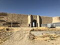
Preserved remains of the citadel walls

Oriental bath


A little away is an oriental bath house from the 16th century. The semi-underground structure has several domes and consists of fired square bricks; the facades are not decorated. It has nine rooms of different sizes and with different functions, and their construction times also differ. The monument was restored in 1979. The Shuma Mosque is located in the former historical center of the city. It consists of a single room with a rectangular floor plan and a flat roof; it dates from the 19th century. The building was restored in 1980, today it is no longer used as a mosque. Right next to it is the Hilvet Mosque, an underground mosque . It dates back to the 16th century and was used by Hodja Ahmad Yasawi and his followers as a place for ritual ceremonies. In the 1940s it was largely destroyed by the local government as its bricks were being used to build a dairy. It was later reconstructed. A little further south are the remains of the ancient settlement of Kultobe.
Economy and Infrastructure
traffic
The Trans-Aral Railway runs through the city and connects Orenburg in Russia with Tashkent in Uzbekistan . The M32 , which starts in western Kazakhstan and leads to Schymkent , runs through the city .
education
In the city that is Ahmet Yesevi University home.
sons and daughters of the town
- Igor Girsanov (1934–1967), Soviet mathematician
- Altai Kölginow (* 1978), politician
- Beksat Sattarchanov (1980-2000), boxer
- Ömirsaq Schökejew (* 1964), politician
See also
Web links
- Official website of the city of Türkistan (Kazakh and Russian)
Individual evidence
- ↑ Численность населения Республики Казахстан по полу в разрезе областей и столицы, столицы, столицы, анколицы, столицы, городоав, областей и столицы, анкония, горойцы, коники, городоав,. ( Excel ; 96 KB) stat.gov.kz, accessed on July 19, 2020 (Russian).
- ↑ Погода в Туркестане. Температура воздуха и осадки. Июль 1983 г. pogodaiklimat.ru, accessed August 9, 2019 (Russian).
- ↑ Публичное подписание Указа «О некоторых вопросах административно-территориального устрой in Russian (on June 26th, 2018)
- ↑ Мавзолей Рабии Султан Бегим - первый мавзолей, созданый мастерами Туркестана. , accessed April 24, 2020 (Russian).
- ^ East Bathhouse. azretsultan.kz, accessed on April 24, 2020 (English).
- ↑ Мечеть Жума в Туркестане. , accessed April 25, 2020 (in Russian).
- ^ Sacred sites of Turkestan. Qazaqstan Tarihy, accessed April 25, 2020.
| Cities |
Arys | Kentau | Lenger | Saryaghash | Shardara | Shetissai | Türkistan (administrative center) |
|
| Further district centers |
Abai | Aqsukent | Myrsakent | Qasyghurt | Shayan | Schäuildir | Scholaqqorghan | Temirlan | Turar Rysqulov |
