Kyzylorda (area)
|
Qysylorda region Қызылорда облысы Кызылординская область |
||
|
||
| Basic data | ||
|---|---|---|
| State : |
|
|
| Administrative headquarters : | Kyzylorda | |
| Founded: | January 15, 1938 | |
| Area : | 226,019 km² | |
| Residents : | 803,531 (Jan 1, 2020) | |
| Population density : | 4 inhabitants per km² | |
| Time zone : | WKST ( UTC + 5 ) | |
| Postal code : | 12xxxx | |
| Telephone code : | +7 (724) | |
| License plate : | 11 (old: N) | |
| KATO code: | 430000000 | |
| ISO 3166-2 : | KZ-KZY | |
| Äkim ( governor ) : | Gülschara Abdiqalyqowa | |
| Website : | ||
| Location in Kazakhstan | ||
The Qysylorda region ( Kazakh Қызылорда облысы Qysylorda oblyssy , Russian Кызылординская область Kysylordinskaja oblast ) is a province of Kazakhstan . The capital is the city of Kyzylorda .
The province itself has a population of 804,000. Other large settlements are Qasaly ( Kasalinsk ) and the Russian- administered Baikonur , which maintains the "spaceport" Baikonur Cosmodrome .
geography
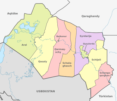
The province borders on neighboring Uzbekistan as well as three other provinces: Aqtöbe , Karagandy and Turkistan . The Syr Darya River , which flows from the Tienschan to the Northern Aral Sea , runs through the province of Qysylorda. The total area of the province is 226,000 km².
population
|
|
|
|
¹ census result
Politics and administration
Administrative division
The area is divided into nine districts ( Kazakh Ауданы Audany ; Russian Район Rajon ). The cities of Baikonur and Qysylorda each represent their own urban district. Other cities in the Qysylorda area are Aral and Qasaly .
| Audany | Area [km²] | Residents | Administrative headquarters |
|---|---|---|---|
| Aral | 55,100 | 79,693 | Aral |
| Baikonur (city) | 55 | 39,341 | Baikonur |
| Qarmaqschy | 31,000 | 53,781 | Lapaly |
| Qasaly | 37,400 | 77,373 | Äiteke Bi |
| Kyzylorda (city) | 2,400 | 312,861 | Kyzylorda |
| Shawl hash | 27,100 | 35,098 | Shawl hash |
| Shangaqorghan | 15,400 | 84,383 | Shangaqorghan |
| Schijeli | 34,300 | 82,612 | Schijeli |
| Syrdarija | 77,600 | 38,389 | Terengösek |
| As of January 1, 2020 | |||
Äkim (governor)
List of governors ( Kazakh Әкім , Äkim ) of the Kyzylorda region since 1992:
| No. | Surname | Term of office (beginning) | Term of office (end) |
|---|---|---|---|
| 1 | Seiilbek Schauchamanow | 1992 | 1995 |
| 2 | Berdibek Saparbayev | 1995 | 1999 |
| 3 | Serikbai Nurghissayev | July 1999 | April 2004 |
| 4th | Ikram Adyrbekow | April 2004 | February 2007 |
| 5 | Muchtar Qul-Muchammed | February 2007 | March 12, 2008 |
| 6th | Bolatbek Quandyqow | March 12, 2008 | 17th January 2013 |
| 7th | Qyrymbek Köscherbajew | 17th January 2013 | June 28, 2019 |
| 8th | Quanyschbek Ysqaqow | June 28, 2019 | March 28, 2020 |
| 9 | Gülschara Abdiqalyqowa | March 28, 2020 | officiating |
Web links
- Homepage of the Province of Kyzylorda (Kazakh and Russian)
Individual evidence
- ↑ Численность населения Республики Казахстан по полу в разрезе областей и столицы, столицы, столицы, анколицы, столицы, городоав, областей и столицы, анкония, горойцы, коники, городоав,. ( Excel ; 96 KB) stat.gov.kz, accessed on July 19, 2020 (Russian).
Coordinates: 45 ° 0 ' N , 64 ° 0' E


