
Újezd pod Přimdou
| Újezd pod Přimdou | |||||
|---|---|---|---|---|---|
|
|||||
| Basic data | |||||
| State : |
|
||||
| Region : | Plzeňský kraj | ||||
| District : | Tachov | ||||
| Municipality : | Přimda | ||||
| Area : | 386.7842 ha | ||||
| Geographic location : | 49 ° 42 ' N , 12 ° 41' E | ||||
| Height: | 572 m nm | ||||
| Residents : | 83 (2001) | ||||
| Postal code : | 348 06 | ||||
| License plate : | P | ||||
| traffic | |||||
| Street: | Tachov - Přimda | ||||


Újezd pod Přimdou (German Ujest b. Pfraumberg ) is a district of the city of Přimda in the Czech Republic . It is located two kilometers north of Přimda and belongs to the Okres Tachov .
geography
Újezd is located at the northeastern foot of the Přimda mountain (848 m) on Mlýnecký potok. Jalovcový vrch ( Grammelberg , 640 m) rises to the east of the village . In the north, the place is affected by the D 5 motorway, whose next exit 136 is in Mlýnec.
Neighboring towns are Labuť in the north, Mlýnec pod Přimdou in the northeast, Velké Dvorce in the southeast and Přimda in the south. To the northwest lies the abandoned village of Bohuslav ( Wusleben ).
history
The first mention of villa ugiezd comes from the year 1414. Other similar spellings such as “Czerweny Ugezd”, “Uges” or “Ugitz” cannot be clearly identified with today's Újezd pod Přimdou. The place name probably comes from the Czech ujezd , German Umlauf, and means the symbolic act of crossing the border when purchasing land. The name Újezd occurs about 100 times in Bohemia. In 1596 "Augezd" came to the municipality of Pfraumberg , which in 1598 had to sell it to the rule of Großmeierhöfen. The berní rula has five farmers, two chalupners and seven wastelands. In 1722 there were 24 properties in Ujest, in 1788 there were 32.
After the abolition of patrimonial formed Ujest / Oujezd after 1850 with the establishment Schlossberg a municipality in the judicial district Pfraumberg and Pilsener circle. From 1868 the community belonged to the Tachau district . The Czech place name was changed to Újezd at the end of the 19th century . In 1900 the village consisted of 53 houses and had 300 German residents. There was a one-class village school in the village. The forestry department on the Pfraumberger Schloßberg was also part of the cadastre. The population was 326 in 1910, 308 in 1930, and in 1939 290 people lived here in 71 houses, two of which were on the Schloßberg .
After the Munich Agreement , the community was added to the German Reich in 1938 and belonged to the Tachau district until 1945 . The village was always parish to Pfraumberg. After the Second World War, the German residents were expelled .
Since 1950 the community has been called Újezd pod Přimdou . 1961 Mlýnec was incorporated. In 1980 it was incorporated into Přimda . In 1991 the place had 72 inhabitants. In 2001 the village consisted of 36 houses in which 83 people lived. In 2004, 83 permanent residents lived in the 41 houses in the village that were permanently used for residential purposes.
school
In March 1812, Andreas Bogner is named as the first demonstrable teacher in Ujest. The school (house no. 9) with the attached teacher's apartment (house no. 39) were located near the war memorial. The last teachers were:
- ? –1912 Karl Schreiner
- 1912–1932 Lorenz Millauer
- 1932–1935 Franz Menegat (substitute teacher)
- 1935–1945 Hans Radl from Sorghof .
Attractions
- Chapel of John the Baptist, built in 1869. The chapel was demolished in the 1950s and rebuilt between 1993 and 1994. The consecration took place in 1994.

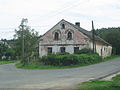
Houses 5, 8, 10, 11 and 12
House 22
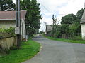
Road towards Milles
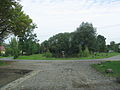
Pond


literature
- Josef Frank (Ed.): Ujester night watchman. Narrators from the past and present to remember and edify. Issue 1-78, year 1976-1997, ZDB -ID 1330568-2 .
- Wolf-Dieter Hamperl: Expulsion and escape from the Tachau district in the Egerland. Fates in reports, documents and pictures.
- Volume 1. Mediform-Verlag, Seebruck 1997, ISBN 3-9803622-2-1 ;
- Volume 2. Druck- und Verlags-Haus Erdl, Trostberg 1996, ISBN 3-925249-38-9 .
- Josef Schnabl: Home atlas of the former political district Tachau-Pfraumberg. (Based on the collection of rescued maps, plans, photos and records from the local supervisors and residents of the former communities). Local history working group of the Tachauer, Geretsried 1973.
- Congregational memorial book, 1994
- School chronicle Ujest from 1925 to 1937 also copied from the original in 1994
Individual evidence
- ↑ http://www.uir.cz/katastralni-uzemi/773824/Ujezd-pod-Primdou
- ^ Michael Rademacher: German administrative history from the unification of the empire in 1871 to the reunification in 1990. Tachau district. (Online material for the dissertation, Osnabrück 2006).

Kundratice (Konraditz) | Malé Dvorce (Klein Meierhöfen) | Málkov (Molgau) with Svatá Apolena (St. Apollonia) | Mlýnec (Milles) | Přimda with Mílov (Mühlloh) | Rájov (Rail) | Třískolupy (Drißgloben) | Újezd pod Přimdou (Ujest) | Velké Dvorce (Groß Meierhöfen)