Acochaca District
| Acochaca District | |
|---|---|
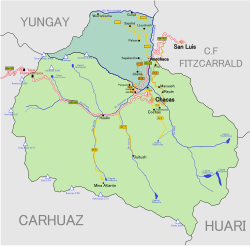
 The Acochaca district (marked in dark green) is located in the north of the Asunción province |
|
| Basic data | |
| Country | Peru |
| region | Ancash |
| province | Asunción |
| Seat | Acochaca |
| surface | 76.5 km² |
| Residents | 3038 (2017) |
| density | 40 inhabitants per km² |
| founding | December 30, 1883 |
| ISO 3166-2 | PE-ANC |
| politics | |
| Alcalde District | Edgar Benedicto Arce Ramírez (2019-2022) |
| The area across the river belongs to the Acochaca district | |
Coordinates: 9 ° 6 ′ 53 ″ S , 77 ° 22 ′ 6 ″ W
The Acochaca district is located in the Asunción province in the Ancash region in western Peru . The district was established on December 30, 1883. It has an area of 76.5 km². The 2017 census counted 3,038 inhabitants. In 1993 the population was 4712, in 2007 it was 3720. The district administration is located in the 3350 m high village of Acochaca with 261 inhabitants (as of 2017). Acochaca is located 5 km north of the provincial capital Chacas .
Geographical location
The Acochaca district lies on the eastern flank of the Cordillera Blanca and extends over the north of the Asunción province. The Río Chucpin flows along the eastern district boundary and drains the area to the north. Its left tributary Río Ruricocha (also Río Cunya) runs along the northern district border.
The Acochaca District borders on the Chacas District to the south, the Yanama District ( Yungay Province ) to the west and north and the San Luis District ( Carlos Fermín Fitzcarrald Province ) to the east .
Web links
- Peru: Region Ancash (provinces and districts) at www.citypopulation.de

