Adenauerring (Karlsruhe)
| Adenauerring | |
|---|---|
| Street in Karlsruhe | |
| Basic data | |
| place | Karlsruhe |
| District | Oststadt , Downtown East , North City , Downtown West |
| Created | 1927-1931 |
| Hist. Names | Parkring , Horst-Wessel-Ring |
| Name received | 1967 |
| Connecting roads | Reinhold-Frank-Strasse, Kapellenstrasse |
| Cross streets | Moltkestrasse , Knielinger-Allee, Michiganstrasse, Willy-Andreas-Allee, Binsenschlauchallee, Willy-Brandt-Allee, Eggensteiner Allee, Linkenheimer Allee, Grabener Allee, Friedrichstaler Allee, Stutenseer Allee, Theodor-Heuss-Allee, Lärchenallee, Hagsfelder Allee, Engler- Bunte-Ring, Richard-Willstätter-Allee, Am Fasanengarten, Engesserstraße, Karl-Willhelm-Straße, Kaiserstraße , Durlacher Allee |
| Places | Durlacher gate |
| use | |
| User groups | Pedestrian traffic , bicycle traffic , individual traffic |
| Technical specifications | |
| Street length | 4 km |
The Adenauerring is a four-lane, ring-shaped bypass in Karlsruhe . The street is located in the Hardtwald north of Karlsruhe Palace and connects the west and east of Karlsruhe past the city center.
Location and course
The Adenauerring is located in the north of Karlsruhe and runs over long stretches through the Hardtwald. The road has two directional lanes with two lanes each. There are footpaths and bike paths on the two outer edges .
As the name part -ring describes, the road follows a ring-shaped course. The radius of the ring is approximately 1,100 meters. Its center is about 100 meters northwest of the castle tower.
The Adenauerring is crossed by some avenues that radiate out from Karlsruhe Palace. Four avenues run as bicycle and pedestrian bridges over the Adenauerring: Knielinger Allee (Toni-Menzinger-Brücke), Linkenheimer Allee, Hagsfelder Allee and Richard-Willstätter-Allee.
The eastern section of the Adenauerring separates the city districts Oststadt and Innenstadt-Ost . The western section separates the north city from the city center-west .
In the southeast, the Adenauerring begins at Durlacher Tor as a continuation of Kapellenstrasse from Durlacher Allee . Initially, the Adenauerring runs northwards along the campus of the Karlsruhe Institute of Technology . To the west of the ring, there are institute buildings and other facilities, the student house and the cafeteria on Adenauerring . To the east of the ring is the former children's clinic with an international student office , a student residence, the university's botanical garden and the ecological learning garden of the Karlsruhe University of Education .
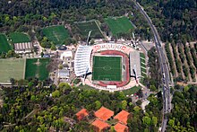
Around the intersection with the Engler-Bunte-Ring, the curve of the Adenauerring begins towards the northwest. The road continues through the Hardtwald. There it leads past several sports and leisure facilities, including the Wildpark Stadium . Along this north-eastern section of the Adenauerring there are generous parking spaces with the forest car park and the birch car park .
To the west of the Adenauerring is the north town. Shortly before the western end, where it turns into Reinhold-Frank-Strasse from the intersection with Moltkestrasse , there is the Karlsruhe University of Applied Sciences to the east and a synagogue to the west .
Sports facilities and leisure facilities on the Adenauerring
There are several sports and leisure facilities along the Adenauerring.
Leisure facilities at the Adenauerring:
Clubs and institutions with sports facilities on the Adenauerring:
- Free Games and Sports Association Karlsruhe eV (FSSV)
- Karlsruhe Gymnastics Club 1846
- Karlsruher SC
- Schützengesellschaft Karlsruhe 1721 eV
- Olympia Hertha game association 1908
- Karlsruher Institute for Technology
history
For a long time the east-west axis through the castle tower was considered the northern development boundary of the city of Karlsruhe . When the Republic of Baden was established in 1918, however, the northern Hardtwald was considered for city expansion. The development of the Adenauerring goes back to a general development plan of the municipal civil engineering office from the 1920s, of which only individual sub-projects were implemented. The Adenauerring was built between 1927 and 1931 as part of the Waldringstraße sub- project , with the aim of relieving the city center and developing newly built sports facilities.
From the opening of the first sections in 1929 until 1933, the street was called Parkring . During the Nazi era , between 1933 and 1945, the street was renamed Horst-Wessel-Ring , after Horst Wessel . The street was then given its original name Parkring again . In 1967 the street was named Adenauerring, named after Konrad Adenauer .
As part of the implementation of the combined solution , construction work for the Durlacher Tor underground station has been taking place at the eastern end of the Adenauerring since 2011 .
Web links
- Adenauerring in the Stadtwiki Karlsruhe
Individual evidence
- ↑ University garden . Karlsruhe University of Education, accessed on September 1, 2015 .
- ↑ Minh-Chau Tran: City and Forest: From urban planning handling of the forest near the city, illustrated using the example of the urban development of Karlsruhe 1870-2000 . Dissertation. Universitätsverlag Karlsruhe, Karlsruhe 2008, ISBN 978-3-86644-257-3 , doi : 10.5445 / KSP / 1000008778 ( Online [PDF; 16.0 MB ; accessed on September 3, 2015]).
- ↑ Harald Ringler: Glance into history No. 62. The city planner Carl Peter Pflästerer - Over three decades of Karlsruhe planning history. City of Karlsruhe, March 19, 2004, accessed on August 27, 2015 .
- ↑ City Chronicle Karlsruhe. Adenauerring. City of Karlsruhe, accessed on August 27, 2015 .
- ↑ Street names in Karlsruhe. (PDF) (No longer available online.) Property Office Karlsruhe, archived from the original on May 22, 2015 ; accessed on July 21, 2015 . Info: The archive link was inserted automatically and has not yet been checked. Please check the original and archive link according to the instructions and then remove this notice.
Coordinates: 49 ° 1 ′ 27.4 " N , 8 ° 24 ′ 11.7" E

