Kaiserstrasse (Karlsruhe)
| Kaiserstrasse | |
|---|---|
| Street in Karlsruhe | |
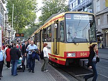
| Kaiserstrasse between Herrenstrasse and Ritterstrasse (2005) | |
| Basic data | |
| place | Karlsruhe |
| District | Inner city east , inner city west |
| Hist. Names | Long street |
| Name received | May 21, 1879 |
| Connecting roads | Adenauerring , Durlacher Allee , Kaiserallee, Kapellenstrasse |
| Cross streets | Adlerstrasse, Brunnenstrasse, Douglasstrasse, Fasanenstrasse, Fritz-Erler-Strasse , Herrenstrasse, Hirschstrasse, Karl-Friedrich-Strasse , Karlstrasse, Kreuzstrasse, Kronenstrasse, Lammstrasse, Ritterstrasse, Waldhornstrasse, Waldstrasse |
| Places | Berliner Platz, Durlacher Tor , Europaplatz , Kaiserplatz , Kronenplatz , market square , Mühlburger Tor |
| S-Bahn stations | Durlacher Tor - KIT Campus South , Europaplatz / Postgalerie , Herrenstrasse, Kronenplatz, Marktplatz |
| use | |
| User groups | Pedestrian traffic , bicycle traffic , individual traffic , public transport |
| Road design | Orientation numbering |
| Technical specifications | |
| Street length | 2.1 km |
The Kaiser Street is the main shopping street of the German city of Karlsruhe .
Location and course
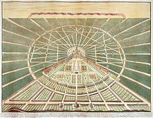
Kaiserstraße crosses the Karlsruhe districts of downtown east and downtown west in an east-west direction and in a straight line for about two kilometers . It runs from Durlacher Tor to Kaiserplatz and touches Berliner Platz , Kronenplatz , Marktplatz and Europaplatz . At differently acute angles, it cuts the nine fan-shaped streets of the radial inner city plan that run towards the castle. At the market square it meets Karl-Friedrich-Straße , the central north-south axis of the city plan, at a right angle .
In the eastern area between Durlacher Tor and Kronenplatz, north of the street, lies the university campus south of the Karlsruhe Institute of Technology and south of it the former day laborers quarter and redevelopment area Dörfle, also known as the old town . Coming from the Dörfle near the Durlacher Tor, Brunnenstraße joins Kaiserstraße at about a 45-degree angle. As a contact yard for prostitution, it is cordoned off with screens. Brunnenstraße between Kaiserstraße and Zähringerstraße is excluded from the Karlsruhe restricted area . This makes Kaiserstraße one of the few main shopping streets in Germany where prostitution can legally be practiced in the immediate vicinity.
Between Fritz-Erler-Straße and Douglasstraße (on Europaplatz), Kaiserstraße is a pedestrian zone with numerous retail shops. The actual retail and service center of Karlsruhe is located in the western area of the pedestrian zone between Marktplatz and Europaplatz. Several department stores are located here, including Karstadt (formerly the Geschwister Knopf department store ) and the Postgalerie shopping center in the former main post office on Europaplatz.
Kaiserstraße is a heavily frequented tram and light rail route, which is also crossed directly by lines from the surrounding area. The Kaiserstraße has been tunneled under since 2010 in order to move the rail traffic underground as part of the combined solution .
At Durlacher Tor, Kaiserstraße runs towards the neo-Gothic tower of St. Bernhardus Church , which closes the line of sight here and is one of the tallest buildings in Karlsruhe at just under 88 m . The road bends slightly to the south here and continues as Durlacher Allee to the east into the center of Durlach. To the west, behind Kaiserplatz and the Mühlburger Tor , the street continues as Kaiserallee straight through the western part of the city to Mühlburg, where it turns into Rheinstraße and Am Entenfang meets Bundesstraße 36 and the Südtangente .
history
Surname
Kaiserstrasse was given its current name on May 21, 1879 on the occasion of the golden wedding anniversary of Kaiser Wilhelm I and Empress Augusta . Previously it was called Lange Straße or Lang Gass from around 1760, in the area east of Waldhornstraße initially Pfannenstihl and later Friedrichs Straße. In the first half of the 18th century, different names were common, such as Landstraße, Landstraß auf Mühlburg, Groß Allee von Mühlburg, Große Straße or Breite Straß.
development
The road existed as a country road through the Hardtwald even before the city was founded in Karlsruhe (1715) . It connected the cities of Durlach and Mühlburg , which are now Karlsruhe districts, and ran over Gottesaue . In the early phase of the planned city of Karlsruhe, the country road formed the base and the southern end of the fan-shaped floor plan. From 1719, buildings were built along the street. Due to its convenient location, Kaiserstraße was a popular address for businesses from the start. Also from 1719, the Konkordienkirche was built on the southern edge of the street, centrally opposite the castle , which in 1807 had to make way for the city expansion to the south and the enlargement of the market square.
During the Second World War , Kaiserstrasse was badly damaged by air raids. By the end of 1947 the rubble had been cleared and an ideas competition on Kaiserstraße was announced. The reconstruction took place as a new building with monument islands, a shopping street that was modern by the standards of the time was created. In the area between Markt- and Europaplatz, the southern house front was set back by six meters from the first floor to improve the street lighting. For the delivery service roads were created in the rear area.
Between 1972 and 1984 the pedestrian zone in Kaiserstrasse was gradually built. The inauguration of the first section between Herrenstrasse and Ritterstrasse was on 6/7. September 1974. In October 1984 the car-free area from Europaplatz to Kronenplatz was ready.
In order to counteract the strong concentration of trade and services in the city center of Karlsruhe on the linear area of Kaiserstraße and to revitalize the southern city center, the city approved the Ettlinger Tor Karlsruhe shopping center, which opened in 2005, about 300 m south of it .
Web links
- Kaiserstraße in the Stadtlexikon Karlsruhe of the city archive
- Kaiserstraße in the Stadtwiki Karlsruhe
Individual evidence
- ^ Statutory ordinance of the Karlsruhe Regional Council on the prohibition of prostitution in the Karlsruhe district of March 1, 1988, accessed on February 4, 2013
- ^ Walter Born: The high German church towers . Lax, Hildesheim 1979, ISBN 3-7848-7010-4 . (Height indication 87.90 based on official measurements.)
- ↑ Stadtchronik Karlsruhe Retrieved on August 12, 2012.
- ↑ Gottfried Leiber : Friedrich Weinbrenner's urban development work for Karlsruhe. Baroque town planning and Weinbrenner's first classicist designs. Braun, Karlsruhe 1996, ISBN 3-7650-9041-7 , p. 112
- ^ City of Karlsruhe City Archives (ed.): Karlsruhe. The city history. Badenia, Karlsruhe 1998, ISBN 3-7617-0353-8 , p. 78 f.
- ^ City of Karlsruhe City Archives (ed.): Karlsruhe. The city history. P. 547 f.
- ^ City of Karlsruhe City Archives (ed.): Karlsruhe. The city history. P. 660
- ↑ Stadtchronik Karlsruhe Retrieved on August 12, 2012.
- ↑ Stadtchronik Karlsruhe Retrieved on August 12, 2012.
- ^ Karlsruhe district profiles: city center. Retrieved August 12, 2012.
Coordinates: 49 ° 0 ′ 34.4 " N , 8 ° 24 ′ 17" E


