
Combined solution (Karlsruhe)
| Karlsruhe city railway tunnel | |||||
|---|---|---|---|---|---|
_am_Tag_der_Inbetriebnahme.jpg) Marktplatz (pyramid) stop on the day of commissioning in December 2021
|
|||||
| Official name | Combined solution Karlsruhe | ||||
| use | Underground tram to BOStrab | ||||
| traffic connection | Tram and light rail Karlsruhe | ||||
| location | Karlsruhe | ||||
| length | 2451 m (east-west tunnel) + 891 m (south branch without triangle) | ||||
| Number of tubes | 1 | ||||
| building | |||||
| Client | CHEESY | ||||
| start of building | January 21, 2010 | ||||
| completion | Light rail tunnel and above-ground Kriegsstrasse: December 11, 2021 Car tunnel : March 2022 |
||||
| planner | CHEESY | ||||
| operation | |||||
| operator | CHEESY | ||||
| Combined solution overview | |||||
 Components and location of the combined solution
|
|||||
| position | |||||
|
|||||
| Coordinates | |||||
| West portal | 49 ° 0 ′ 37 ″ N , 8 ° 23 ′ 14 ″ E | ||||
| East portal | 49 ° 0 ′ 30 " N , 8 ° 25 ′ 14" E | ||||
| South portal | 49 ° 0 ′ 4 " N , 8 ° 24 ′ 11" E | ||||

The combined solution is a project to further develop the standard-gauge tram network in Karlsruhe .
It consists of the project parts
- City railway tunnel under Kaiserstraße between Mühlburger and Durlacher Tor with a south branch from Marktplatz under Karl-Friedrich- and Ettlinger Straße to Augartenstraße,
- Tram in the Kriegsstrasse between Karlstor and Mendelssohnplatz,
- Rail-free pedestrian zone between Europaplatz and Kronenplatz .
Light rail tunnel
The sub-project urban railway tunnel consists of:
- the construction of seven underground stations
- the new construction, renovation or relocation of six above-ground stops
- the construction of an underground triangular track
- the construction of three ramps
- the construction of an east-west tunnel tube
- the construction of a north-south tunnel tube
- the preliminary construction work for a north-east branch
Stops and Gleisdreieck
Most of the underground stops are built using the top-down method after the construction site has been cleared and explosive ordnance has been explored . Originally it was planned to create all side walls as bored pile walls , but diaphragm walls were used at some stops . The tunnel lies in the Upper Rhine Plain , a rift valley that is filled with several 1000 m thick sediment . Therefore, unlike other projects, the walls cannot reach solid or at least waterproof layers. Instead, a temporary floor is created using the jet grouting method, the tightness of which is checked by pumping tests. Finally, the temporary floor is anchored, a cover is concreted and the surface is restored. Under the protection of the structure created in this way, the earth's core can be removed and then the final floor, walls, false ceilings, track basin and platforms can be built.
The underground stops are (measured inside) 100 m long. The platform is divided into an 80 m long section with 34 cm platform height for barrier-free access to low-floor trams and a 15 m long section with 55 cm platform height for barrier-free access to the first two doors of middle-floor trams of the two-system lines, in between a 5 m long section Ramp. The stops are designed for up to 75 m long double traction according to BOStrab . Most stops have a platform level and an intermediate level. One elevator per platform ensures barrier-free accessibility.
The main structure of the Europaplatz stop of the east-west tunnel begins on the east edge of Douglasstrasse and ends in the middle of Karlstrasse. Two escalator entrances from the square and from the pedestrian zone east of Karlstrasse and one stair entrance from the northern Karlstrasse should lead to the eastern mezzanine level, Postgalerie on the south side and Saturn on the north side can be connected to this. The western mezzanine level has only two staircases. The elevators go through to the platform level without access to the intermediate levels. The rails are 13 m below the site. The walls were created with bored pile walls. There are two construction sites, the first of which was started on the south side in mid-2010. In this construction phase, the above-ground triangle was only accessible from the east on a single track. The change to the northern construction site took place with the restoration of the track triangle with a considerable delay in May 2012. In June 2014, the old track layout was restored, and in November 2014 the above-ground and low-floor barrier-free stop directly on the square was reopened.
The main structure of the Lammstrasse stop of the east-west tunnel begins east of Ritterstrasse. A small mezzanine level can be reached from there by stairs and escalator. Another mezzanine level can be reached with two stairs and an escalator in only one direction and from Karstadt . The elevators directly to the platform level are in between. The rails are 13 m below the site. On the east side, the structure of the bus stop merges with that of the triangular track. The eastern mezzanine level can be reached with another escalator from Kaiserstraße.

The intermediate level also merges into the structure of the Gleisdreieck , so that the Marktplatz stop of the southern branch can be reached underground, the structure of which is directly connected to that of the Gleisdreieck. On the intermediate level between Lammstrasse and Marktplatz, a public toilet facility will also be set up, which will replace the previous facility on the Marktplatz, which was closed due to construction. The northern mezzanine level of the Marktplatz stop can be reached from the northern square using a flight of stairs, an escalator and a single elevator with a stop on the mezzanine level and the western platform. You have to change to another elevator for the eastern platform. The southern mezzanine level has only one stair access. In addition to the two continuous tracks, the stop has a third stump track on which dual-system lines such as those from the Murg Valley can end . This track is a little lower, so that it has a platform height of 55 cm. The idea of integrating an event room above this track on the mezzanine level was abandoned because of the high fire protection requirements, as were all the ideas for kiosks, etc. before that. The rails are 13.4 m below the site. Construction began in 2010 with the southern construction site of the Lammstrasse stop in front of the Karstadt building. In doing so, unknown load-bearing foundation parts were encountered, which led to considerable loss of time. The walls of the Lammstrasse stop were built with bored piles. The change to the northern construction site took place at the end of 2012. The walls of the Marktplatz stop and the Gleisdreieck will be built with diaphragm walls. In spring 2013, taking advantage of the closure of the Marktplatz - Kronenplatz section, the construction of the eastern part of the Gleisdreieck began. The completion, including the lifting of the blockage of this section, took place as planned on November 18, 2013. From then on, the southern branch on the market square was blocked in order to begin the stop there, the preparatory work for this, such as the laying of cables, began in spring. The closure of the south branch was originally only supposed to last two to three years, after which it was to be provisionally restored until the combined solution including the war road and the associated final aboveground closure were completed. At the beginning of 2015, however, the decision was made to forego this and to keep the replacement bus service and, if necessary, to extend it to the market square. The retailers along the way protested.
The main structure of the Kronenplatz stop of the east-west tunnel begins in the pedestrian zone at Kaiserstraße 20 and extends to a few meters in front of the historic main building of the technical university . The western mezzanine level can be reached by stairs and escalator from the pedestrian zone, the middle one by stairs from Waldhornstrasse and the lifts that also stop on the mezzanine level. The eastern mezzanine level has stair and escalator access to Englerstrasse in the direction of the university campus. Diaphragm walls are used here. The rails are 13 m below the site. Construction began in 2010 with the northeast construction site, the change to the southeast construction site took place in September 2012. From June 2012 to April 2013, the southern branch up to Baumeisterstraße was not accessible. In spring 2013, construction of the west end of the stop began, for which the section Marktplatz - Kronenplatz was closed. By November 2013, the 15-month delay in the construction process could be made up in seven months by merging the two western construction sites.
The main structure of the Durlacher Tor stop of the east-west tunnel begins at the east end of Kaiserstraße before reaching the square. The western mezzanine level has stair and escalator access from the campus and stair access on the south side of Kaiserstraße. The two elevators also stop at her. The eastern mezzanine level has stairs and escalators on the north side and stairs and lifts on the south side. The rails are 11 m below the site. The building structure of the stop, which was built with diaphragm walls, is connected to the east by the construction work for a north-east branch under Karl-Wilhelm-Strasse and the ramp to Gottesauer Platz. After a new company building had already been built because the old one had to give way to the construction site, the actual construction work began in summer 2011. The tunnel boring machine started at the western end of the stop.

The middle of the main structure of the Ettlinger Tor combi structure of the south branch lies roughly in the area of the war road underpass under Ettlinger Tor Platz. This is where both parts of the project intersect. Since the tram tunnel is under the old underpass, it has to be demolished and rebuilt, hence a “combi-structure”. A former pedestrian underpass, in which the music club “Substage” was last located, was also torn down. The intermediate levels are reached with four stairs and three individual escalators at the four corners of the stops. The elevators are not continuous. The Ettlinger Tor shopping center is connected to the northern mezzanine level. The rails are 14 m below the site. Construction with diaphragm walls began in 2011 with the north head, later construction began on the south head. In November 2014, after the north and south head had been completed, the underpass was closed in order to tear it down and replace it with the central section of the stop and the new underpass. The information pavilion for the "K." combination solution with a viewing platform is located near the building.
The main structure of the congress center stop of the southern branch begins south of Nowackanlage street and ends a little south of Schützenstraße. Since the tunnel of the south branch is gradually coming up here, this stop, unlike the others, has no mezzanine level. The two escalators in the south, the two stairs in the north and the two elevators in the middle lead directly to the platform level. The rails are 7.1 m below the site. After the temporary walls and injection base have been fabricated, it is built into this temporary restoration in an open manner. The closure of the southern branch on the market square from November 18, 2013 also includes car traffic on Ettlinger Straße from north to south since January 2014. The opposite direction was moved to the other side at the level of the future stop, so that construction of the stop could then begin. The tram traffic in the course of Baumeister- and Hermann-Billing-Straße and the car traffic there, but only from east to west, are led over auxiliary bridges over the construction site.
In the course of the construction of the tram tunnel, some above-ground stops had to be relocated or newly built. In the east, the Gottesauer Platz stop was first relocated in 2011 from the square west of Wolfartsweierer Straße, where the ramp will be built, to the east of this street and made barrier-free according to the same principle as the underground stations.
In the west, the Mühlburger Tor stop also had to give way to the future ramp. In the spring of 2013 it was moved to the west in front of the Helmholtz-Gymnasium between Scheffelstrasse and Grashofstrasse. The route to the north that had previously branched off to the east was given its own platforms in Grashofstrasse. The stop has a length of around 160 m, as it enables barrier-free entry both in the eastern part for low-floor trams with 34 cm and in the western part for medium-floor trams with 55 cm in each case. It is therefore the first stop that, since July 4, 2013, has offered a barrier-free transfer over a short distance between the two heights over its entire length. It not only replaces the old Mühlburger Tor stop, but also the platforms in the Kaiserallee of the Schillerstraße stop, as these are too close to the new stop. Only their platforms in Schillerstraße itself for Line 1 will be retained, while those in Kaiserallee will be dismantled in summer 2015. Because of the now very large distance to the Europaplatz stop, an additional stop is to be built between Leopoldstrasse and Hirschstrasse for the above-ground railways.
In the course of the construction work, various stops were and will be relocated temporarily, for example at Europaplatz, Kronenplatz, Ettlinger Tor and Durlacher Tor.
Outside the combined solution project, the Mathystraße and Kolpingplatz stops on Karlstraße and the Werderstraße stop on Rüppurrer Straße are being converted into barrier-free stops. Its new length, which is suitable for double traction, is, however, necessary for the diversion during the closure of the Marktplatz south branch. The upcoming construction of the Volkswohnung stop is also not part of the project, while the renovation of the Mendelssohnplatz and Karlstor stops is part of the Kriegsstraße sub-project.
14 large-format ceramic plates of the art project Genesis - Seven Days of the Lord by Markus Lüpertz for the seven central train stations, which should initially be built with the Karlsruhe ceramic manufacturer Majolika , will now be created in the Zeller Keramik Manufaktur , like the association "Karlsruhe Experience Art" in November 2020 announced. At the end of December, Lüpertz presented the first board to Mayor Frank Mentrup on the platform of the future Kronenplatz stop.
Tunnels and ramps
The east-west tunnel is being built using shield driving and has a tube with two tracks. The standard cross-section envisages an inside diameter of 8.20 m with a single-shell segmental lining with a thickness of 40 cm. Including primary compression, the outer diameter is around 9.3 m. The upper edge of the rail, measured on the inside, is 2.60 m above the base or 5.60 m below the ceiling of the tube or 1.50 m below the center of the tube. The track center distance is 3.05 m, the distance between the track axis and the emergency walkway is 1.60 m. This is 28 cm above the upper edge of the rail and, according to the BOStrab rules applicable at the start of construction, is 70 cm wide. The tracks lie in the ballast bed. The shield drive with the tunnel boring machine named "Giulia" at the stop ceremony on October 26, 2014 started in November 2014 in the Durlacher Tor underground station and ended on September 7, 2015 in the approximately 13 m long target shaft under the western part of Kaiserplatz within what is today Round track.
When driving the shield, the Kronenplatz, Lammstraße and Europaplatz stops and the Gleisdreieck were also driven through; the temporary structures had to be ready by then. The tube was then broken off again there and the floor that was still in the temporary stop was removed. The final stop was then built from the inside.
In the course of difficulties in the construction of the Europaplatz and especially Lammstrasse stops (unknown foundations for the Karstadt building) there were delays of up to 18 months. 15 months of this were caught up in 2013 by the 7-month closure of the Marktplatz - Kronenplatz section, as such small building plots could be merged into large ones. The commissioning of the tram tunnel is planned for April 2018 as of April 2013. The shield drive began on November 18, 2014. The construction progress of the tunnel drive is around 10 meters per day. The drive initially turned out to be less problematic than expected. Sometimes it is possible to drive 30 m of tunnels per day. The earth movement above ground is 2 mm. By February 17, 2015, 889 m of tunnels had been built up to Gleisdreieck Marktplatz. Originally, the marketplace should not be reached until Easter 2015. In mid-March 2015, the tunneling was stopped due to unexpected problems in the area of the future underground triangular track on the market square. The work to compact the soil over the tunnel boring machine had taken a few weeks and consumed part of the time cushion.
The eastern ramp in Durlacher Allee starts right after the potential north-east branch directly behind the Durlacher Tor underground station, reaches the daylight with the east portal at the western edge of Bernhardstrasse and ends at the western edge of Buntestrasse or Gottesauer Platz. It has a maximum gradient of 32.0 per mille, a 1600 m summit and 2000 m trough and a length of around 430 m, 230 m of which is open. Switches are connected to above-ground bypass tracks on both sides of the ramp. Since no regular service is planned on the bypass tracks, they are not laid on their own track structure, but in the lanes of Durlacher Allee. The Gottesauer Platz stop had to be relocated in 2012 for the ramp.
The western ramp in Kaiserallee starts after the target shaft of the tunnel boring machine, reaches daylight with the western portal a little west of the western edge of Reinhold-Frank-Straße and ends at the middle of Lessingstraße. It has a maximum gradient of 49.5 per mille, 1600 m summit and 5000 m trough and a length of around 430 m, 150 m of which is open. For reasons of space, it is the steepest of the three ramps. Switches are connected to it for a two-sided bypassing of the ramp, which is also used in line operations, which is therefore given its own track structure. The Mühlburger Tor stop had to be relocated for the ramp. The ramp and target shaft have been under construction since 2014, and the railways have been circumnavigating the construction site on the north side since Whitsun 2014.
The south branch as a north-south tunnel connects to the Marktplatz stop structure and also has a tube with two tracks, apart from a short section at the market place where the third track of the stop branches off. Due to its short length, this section was not drilled, but was built using mining techniques for the first 250 m to the Ettlinger Tor underground station, with the tunnel being driven northwards from Ettlinger Tor. When building tunnels, cement suspension and later water glass have been injected as an injection seal to stabilize the gravelly subsoil since summer 2014 , and the soil is then cleared out under overpressure. The inside dimension of the tunnel is 8.50 in width. Adding 45 cm of in-situ concrete inner shell and 30 cm of shotcrete results in an external dimension of 10.0 m in width. The distance between the track and the ceiling and other track-related dimensions correspond to those of the east-west tunnel. This part of the tunnel crosses under the Karlsruhe Landgraben at a distance of approx. 1–2 m .
The tunnel to the south of Ettlinger Tor, like the congress center stop, was built into this temporary structure after temporary walls and an injection base had been built, with a rectangular cross-section and internal dimensions of 7.85 m in width and 5.40 m in height 80 cm thick walls. The traversing tram line was interrupted for five weeks in March and April 2014 for the installation of an auxiliary bridge over the tunnel.
The southern ramp in Ettlinger Straße develops from this tunnel, reaches the daylight at the south portal 1 m south of house No. 15 (south of Werderstraße) and ends a few meters before the underpass on Augartenstraße. The stop there was relocated to the south of Augartenstrasse. The ramp has a maximum gradient of 35.0 per mille, a 1600 m summit and 3000 m trough and a length of around 320 m, 210 m of which is open. In the final stage, it should not have any bypass tracks or connections to the tram lines crossing in Kriegs- und Baumeisterstraße. For the planned recommissioning of the above-ground route in mid-2016, temporary bypasses are necessary.
With the reopening of the Marktplatz - Kronenplatz section in November 2013, the southern branch from Marktplatz to Ettlinger Straße was closed (the curve without switches built in place of the previous triangle was demolished and the gap on Kaiserstraße closed again without switches), so that the The main part of the work on the southern branch and its stops afterwards begins with the exception of the parts of the Ettlinger Tor stop that are already under construction.
War Street
The Kriegsstrasse sub-project consists of:
- with the construction of a car tunnel under the eastern war road
- the demolition of the Ettlinger Tor underpass and the new construction as a combination structure, see above
- the new construction of a connecting tunnel between the Ettlinger and Karlstor underpasses with four ramps and a one-sided underground connection to the multi-storey car park of the Ettlinger Tor shopping center
- the construction of a tunnel to the east to the east of Kapellenstrasse
- the reduction of the surface road
- the construction of an above-ground tram route with three stops
- the relocation of two more stops
- the replacement of an underpass and two bridges with level crossings
Car tunnel
The Karoline-Luise-Tunnel connects to the existing Karlstor underpass in the west. This will be retained including the western ramps with two lanes in each direction and will only be retrofitted with a partition wall in the underpass that will run through the entire tunnel and separate both directions of travel.
So far, the underpass has widened to the east to three lanes each, all of which have come to the surface as far as Ritterstrasse. However, the Ritterstrasse itself is not connected to the underpass. The previous underpass Ettlinger Tor is in principle built in mirror image between Lammstrasse and Kreuzstrasse: three lanes each down and two lanes each up on the east side.
This will be replaced east of the Karlstore by a continuous car tunnel with initially one lane in each direction. There are two (now shorter) ramps up and down between Karls- and Ettlinger Tor:
- Reachable from the Ritterstraße under the Karlstor through to the west
- from the west up to the Ritterstrasse
- Reachable from Lammstraße under the Ettlinger Tor through to the east
- from the east up to Lammstrasse
On the north side, the shopping center parking garage is connected underground with an entrance from the east and an exit from the west. This was prepared when the center was built.
East of the Ettlinger Tor, the car tunnel remains two-lane without any further exits to the new east portal between Kapellenstrasse and Ostendstrasse. From the east only one lane leads to the exit ramp after Ettlinger Tor. Below the confluence with Kapellenstrasse, the common tunnel structure for both lanes is divided into two independent tubes, only separated by a wall, because the tram route lies above ground between the ramps.
The main carriageway will be 3.50 m wide, the ramp carriageway 3.25 m, the hard shoulder 2.00 m wide for a single lane main carriageway, the two-lane main carriageway will not have a hard shoulder. There are also emergency walkways approx. 1.45 m wide on the left and 1.00 m wide on the right. The single-lane main tunnel is approx. 8.0 m wide inside and the two-lane 9.45 m wide, the external dimension between approx. Kreuzstrasse and approx. Mendelssohnplatz is approx. 20.35 m. In the area of the ramps there are around 28– 29 m, in the area of the ramps and underground connection of the parking garage approx. 31 m wide. The lanes are about seven to nine meters below the site, and seven meters for the combined structure.
The total length of the car tunnel will be 1360 m (south tube east portal) or 1400 m (north tube). Apart from the intermediate ramps, there will be no further entrances. If ventilation is necessary, this is planned at Karlstor in place of the east access to the former pedestrian underpass. The municipal council decided on April 8, 2014 to do without the chimney for the time being and to test other measures to reduce pollutants.
As a construction method, the plan is to set back anchored bored pile walls at a distance of one meter from the tunnel structure and to create an injection base at a distance of approx. 15 m from the site. The actual tunnel is built into this tub in an open manner. The laying of cables for the ramp in Ludwig-Erhard-Allee began in spring 2014. In spring 2015, after the underpass Ettlinger Tor was demolished, see above, the filling of the ramps in order to temporarily manage car traffic and the removal of traffic islands began.
Above-ground road layout

The Kriegsstraße is between Brauer- and Fritz-Erler-Straße, a car-dominated multi-lane urban motorway built in the 1970s with a high separating effect and without bike infrastructure and little quality of stay. Since then , at the level of Nymphengarten , Kriegsstrasse has had a total of ten lanes: four continuous, two interlaced lanes and two residential lanes each. Two pedestrian bridges in the course of Ritterstrasse and Lammstrasse as well as two pedestrian underpasses at Kreuzstrasse and Hirschstrasse create non-barrier-free pedestrian crossings. The latter outside the area of the development plan was supplemented in 2011 by a ground-level and therefore barrier-free crossing for pedestrians and cyclists.
The aim of the part of the war road is also (in addition to the southern expansion of the inner city) to redesign this urban highway in a contemporary way by reducing the separating effect and increasing the quality of stay. The relocation of part of the traffic is a prerequisite for this. Further measures are the reduction of the lanes remaining at the top to mostly only one lane per direction, further above-ground links and crossings, the creation of wheel lanes and greening. Between Karlstor and Ritterstraße there is only one continuous lane next to the ramps. In the course of the Ritterstrasse, a level crossing for pedestrians and cyclists will be created. Between Ritterstraße and Lammstraße there are two lanes each plus a turning lane in front of Lammstraße, because a ground-level node for all types of traffic and directions is created here, including a turning lane on the east side. The two pedestrian bridges are to be demolished. The one in the course of the Ritterstraße will be replaced by a crossing possibility for pedestrians and cyclists. Between Lammstraße and Ettlinger Tor there is one continuous lane in the south, and in some cases two in the north because of the car park entrance.
East of the Ettlinger Tor there remains one lane each up to approximately Meidingerstraße, further east two each lane. Level crossings for pedestrians will be created at Kreuzstrasse and Adlerstrasse to replace the underpass along Kreuzstrasse. A little east of Kapellenstrasse there is again only one lane next to the ramp.
As far as possible, the Kriegsstrasse will be redesigned into an avenue with two to four rows of trees.
tram
The reason for the renovation is an above-ground tram route in Kriegsstraße to complement the tram tunnel. This is connected to the line in Karlstrasse with a triangular track. There at Karlstor a new stop is being built on Kriegsstrasse with 75 m long and 34 cm high platforms, connected only in the direction of Karlstor. In addition, the old stop was relocated north of the gate to the south of the gate, as there was no space in the north for a barrier-free stop suitable for double traction; this has been built since the end of 2012 and was put into operation for the low-floor lines on July 3, 2013, while the old vehicles of line 5 will continue to stop on the north side during their diversion until the end of 2014.
A further 75 m long stop with 3 m wide and 34 cm high platforms is being built to the west of Ettlinger Tor, connected only in the direction of Ettlinger Tor.
At Mendelssohnplatz, a square track is being built to link it to the tram route in Fritz-Erler- and Rüppurrer Straße. A 75 m long stop with 3 m wide and 34 cm high platforms will be built between this and Kapellenstrasse. Because of this, the confluence of Kapellenstrasse will be relocated to the east and run at right angles instead of at an angle as before. A simple junction from the west to the operating line in Kapellenstrasse will be integrated. In addition, the previous stop north of Mendelssohnplatz and the Baumeisterstraße stop south of the same were merged to form a new Rüppurrer Tor stop between Kriegs- and Baumeisterstraße. Its construction began at the end of 2012, was interrupted at the beginning of the closure of Kaiserstraße between Marktplatz and Kronenplatz due to diversion traffic and resumed in July 2013 and ended at the end of 2013.
The tram route ends at Henriette-Obermüller-Strasse, where the previous curve of the tram route in Ludwig-Erhard-Allee will be converted into a simple junction. The route branching off here and opened in September 2012 to bypass the heavily used Mendelssohnplatz junction in the direction of Baumeisterstraße will be retained, not least because of the binding period for the construction grants.
Tram-free pedestrian zone
The U-Strab, which was rejected in the 1996 referendum, was mainly about increasing the efficiency of the main axis of tram and light rail traffic in Kaiserstraße, while relieving the pedestrian zone from tram traffic only played a subordinate role. In contrast, the 2002 referendum focused on the tram-free pedestrian zone. While critics doubt the necessity of tram freedom or even consider it counterproductive, especially at night, proponents emphasize that the different outcome of the referendums shows that tram freedom is wanted by the citizens and will increase the attractiveness of the main shopping street.
The section of Kaiserstraße between Karlstraße and Fritz-Erler-Straße, i.e. between Europaplatz and Kronenplatz, will be tram-free. In particular, the section between exclusive Adlerstrasse and inclusive Europaplatz is considered to be highly frequented with pedestrians. To the east and south of Kronenplatz there will continue to be above-ground tram traffic outside the pedestrian zone, with a stop on Fritz-Erler-Straße. There will also continue to be above-ground tram traffic to the west and south of the current Gleisdreieck at Europaplatz, with a stop on Europaplatz. There is therefore still (reduced) rail traffic in a pedestrian area. With the new above-ground stop between Hirschstrasse and Leopoldstrasse, car traffic to the west of it will probably hardly play a role anymore.
As a result of this measure, today's above-ground southern branch from Marktplatz will also become tram-free and thus also the pedestrian zone Marktplatz, but also the area of Karl-Friedrich-Straße and Ettlinger Straße reaching up to the ramp in Augartenstraße, since the ramp will have no bypasses and thus none There is a possibility of continuing to offer above-ground tram traffic there.
Under the motto "the railways below and life above", the new possibilities of a train-free pedestrian zone as a "promenade" were advertised in the election campaign with street cafes, people chatting in a relaxed manner, happy children, play opportunities, street painters and musicians and the shop displays as more attractive shopping experience.
This was made more concrete between summer 2009 and March 2010 with a “Competition Kaiserstraße and Karl-Friedrich-Straße”, which included the area of the entire Kaiserstraße between Durlacher and Mühlburger Tor including and the entire Karl-Friedrich-Straße up to the Ettlinger Tor exclusive. Here ideas were collected and evaluated for the design of the pavement, the furniture, the lighting and the greenery.
In spring 2013, as a first measure to implement the competition results, some test areas were covered with the proposed plasters in order to test their suitability.
In contrast to the project parts of the urban railway tunnel and Kriegsstraße, which are secured by planning law, the freedom of the pedestrian zone is not legally stipulated. Since the binding effect of a referendum in Baden-Württemberg is only ever three years, the decision of 2002 has only been a moral obligation since 2005, to which, however, all major Karlsruhe parties have so far committed. The renovation of the pedestrian zone after completion of the combined solution is not eligible for funding and is therefore not part of the cost accounting.
Other construction work
The above-mentioned conversion of stops outside the two project parts of the Stadtbahntunnel and Kriegsstraße for use by double traction when the market square south branch is closed, is not part of the project including cost accounting, nor is the laying of lines from the construction sites. The elaborate culvert of the “Abwassersammlers Mitte” at the intersection of Ettlinger Strasse with Baumeister Strasse and Hermann-Billing Strasse should be emphasized .
In addition, the information pavilion "K." was built southeast of Ettlinger Tor for a good 800,000 euros and opened in April 2010. In addition to information material and a café, it offers an event room and a viewing platform on the construction site of the combined structure. The name "K." stands for combined solution, Karlsruhe, communication and competence. From July 2009 to 2011, 16 information steles at the (then) future construction sites provided information about the local construction work.
While the Karlsruhe pyramid on the market square and the Grand Duke Karl monument on the Rondellplatz with the constitutional column and probably also the Kaiser Wilhelm monument on the Kaiserplatz are not affected by the construction work, the Ludwigsbrunnen on the market square and the Leibgrenadier monument on the Europaplatz to be dismantled for the construction work. These are then rebuilt. The pyramid was covered with wood for protection; Vibration sensors were installed inside for monitoring purposes.
Line network
Earlier considerations
Even the "conceivable route network for the combined solution" presented shortly after the publication of the combined solution in June 2002 was identical to the line network of the "co-operation" of the standardized assessment , except for small details .

| line | Line network of the combined solution - final state or co-payment |
|---|---|
| 1 | Durlach - tram tunnel - Oberreut |
| 2 | Wolfartsweier - Stadtbahn tunnel - Hbf - Europaplatz - Daxlanden |
| 3 | Waldstadt-Jägerhaus - Kronenplatz - Hbf - Europaplatz - Knielingen-Nord |
| 4th | Waldstadt-Europaviertel - Tullastrasse - Stadtbahn tunnel - Nordstadt - Kirchfeld |
| 5 | Rintheim - Kronenplatz - Konzerthaus - Kühler Krug - Rheinhafen |
| 6th | Durlach - Ludwig-Erhard-Allee - Kriegsstraße - Brauerstraße - Hbf, further as: |
| 7th | Main station - Rüppurrer Straße - Kriegsstraße - Europaplatz - Rheinstrandsiedlung only operates during the peak hours |
| 8th | Wolfartsweier - Durlach |
| S1 / S11 | Albtalbahn - Hauptbahnhof - Stadtbahn tunnel - Nordweststadt - Neureut - Hardtbahn |
| S2 | Stutensee - Tullastrasse - Stadtbahn tunnel - Rheinstetten |
| S4 / S41 | Heilbronn - Bretten - tram tunnel - main station - Rastatt - Murgtal / Achern |
| S5 | Pforzheim - Pfinztal - Stadtbahn tunnel - Wörth |
| S8 | Landau / Germersheim - Hbf - city railway tunnel |
Differences between the current presentation and the “conceivable network” from 2002: At that time, it was assumed that the gap between the end loop Rintheim and Hirtenweg would have been closed, so that lines 3 and 5 could have merged there. The 3 should now be continued to the Jägerhaus. 7 was also extended from Kaiserplatz (planning 2002) to the Rheinstrandsiedlung.
Today's line S31 / S32 is missing in the representations, for which originally the planning of a city center connection with the route ... - Bruchsal - Durlach station - "Rampe Gleisbauhof" - Ludwig-Erhard-Allee - Ettlinger Tor - Hbf - Ettlingen-Erbprinz Ettlingen-Bruchhausen - Rastatt -… that was no longer possible due to the missing track connection at Ettlinger Tor. However, the planning approval for the “Südbahn” Hereditary Prince - Bruchhausen was carried out and the routes around the track construction yard are kept free, most recently in the planning approval for the Südostbahn and the “Durlacher Allee planning workshop”.
Compared to the line network that has been in force since the end of 2008, the final state differs in that the S4 / S41 was broken into the southern branches to Achern and Murgtal, which have since ended in Tullastraße, and in the north branch to Heilbronn, which ends at the main station. Furthermore, the Stadtbahn to Germersheim runs as S51 / S52 on weekdays a ring Germersheim - Kaiserallee - Marktplatz - Hbf - Germersheim or vice versa, instead of ending as S8 at Marktplatz. To what extent these current concepts have an influence on the above network is unknown.
With the previous 10-minute cycle in the tram tunnel, the planned line network therefore contains per hour in the high season:
- between Mühlburger Tor and Marktplatz 5 lines with 33 trams in each direction (including the additional S1 / S11 express trains in the HVZ)
- 9 of them turn off in each direction at the market square (S1 / S11 including express trains)
- between Marktplatz and Durlacher Tor 6 lines with 33 lanes in each direction (S4 / S41 every 20 minutes)
- 9 of them turn off in each direction at Marktplatz (2 and S4 / S41)
- between Marktplatz and Augartenstraße 4 lines with 19 trams in each direction (hourly S8 and express trains S1 / S11)
- Of which 1 lane ends on the 3rd track, taking into account the current break, 2 lanes more would run and then 3 lanes would end
This results in an average headway time of 109 seconds in the east-west tunnel. Similar dense trains are or have been used in other urban railway tunnels in Germany. However, it is disputed to what extent the level underground track triangle on the market square affects the capacity, as there are no models for this in other cities, see also the chapter on the planning phase.
For the "intermediate state" between the commissioning of the tram tunnel (originally planned for the end of 2016) and the completion of the Kriegsstrasse and thus the entire combination solution, the municipal council proposal for the decision on the construction sequence of the tram tunnel versus Kriegsstrasse contained two networks with a pedestrian zone that was then tram-free or not yet tram-free. The decision was made in favor of the latter with the following network:

| line | Line network of the combined solution - intermediate state |
|---|---|
| 1 | Durlach - tram tunnel - Oberreut |
| 2 | Wolfartsweier - Stadtbahn tunnel - Hbf - Brauerstraße - Europaplatz - Knielingen-Nord |
| 3 | Heide - Kronenplatz - Hbf (above ground through Kaiserstraße), further as: |
| 4th | Hbf - Europaplatz - Waldstadt (above ground through Kaiserstraße) |
| 5 | Rintheim - Tullastraße - Ludwig-Erhard-Allee - Konzerthaus - Kühler Krug - Rheinhafen |
| 6th | Daxlanden - Europaplatz - Hbf - Kronenplatz - Hirtenweg |
| 8th | Wolfartsweier - Durlach |
| S1 / S11 | Albtalbahn - Hauptbahnhof - Stadtbahn tunnel - Nordweststadt - Neureut - Hardtbahn |
| S2 | Stutensee - Tullastrasse - Stadtbahn tunnel - Rheinstetten |
| S4 / S41 | Heilbronn - Bretten - tram tunnel - main station - Rastatt - Murgtal / Achern |
| S5 | Pforzheim - Pfinztal - Stadtbahn tunnel - Wörth |
| S8 | Landau / Germersheim - Hbf - city railway tunnel |
This essentially corresponds to the current route network with the 3/4 ring, adapted to the tram tunnel with the detour of the S2 via Tullastraße and a changed route for line 5, as the possibility of traveling via Karl-Friedrich-Straße is no longer available, although compared to today the routes from 5 and 6 east of Mendelssohnplatz have been swapped due to the lack of a turn-off from southern Rüppurrer Strasse into Philipp-Reis-Strasse. Only two lines remained in the pedestrian zone, namely the 3/4 ring with twelve lanes per hour and direction, the main part of the market square would already be tram-free.
The above "coincidence" of the standardized assessment was compared with the following "absence":

| line | Line network of the combined solution - without any standardized evaluation |
|---|---|
| 1 | Durlach - Market Square - Oberreut |
| 2 | Wolfartsweier - Marktplatz - Hbf - Europaplatz - Daxlanden |
| 3 | Hirtenweg - Kronenplatz - Hbf - Brauerstraße - Europaplatz - Knielingen-Nord |
| 4th | Waldstadt-Europaviertel - Europaplatz - Hbf, further as: |
| 6th | Main station - Kronenplatz - Neureut-Kirchfeld |
| 5 | Rintheim - Tullastraße - Ludwig-Erhard-Allee - Konzerthaus - Kühler Krug - Rheinhafen |
| 7th | Durlach - Ludwig-Erhard-Allee - concert hall - cool jug - Rheinstrandsiedlung |
| 8th | Wolfartsweier - Durlach |
| S1 / S11 | Albtalbahn - Central Station - Market Square - Europaplatz - Nordweststadt - Neureut - Hardtbahn |
| S2 | Stutensee - Durlacher Tor - Market Square - Rheinstetten |
| S4 / S41 | Heilbronn - Bretten - market square - main station - Rastatt - Murgtal / Achern |
| S5 | Pforzheim - Pfinztal - Market Square - Wörth |
| S8 | Landau / Germersheim - Albtalbahnhof - Marktplatz - Europaplatz - Albtalbahnhof |
The route of the S8 corresponds to that of the S41 after separation from the S4 circuits, although its final destination was changed to Tullastrasse after the new depot was opened in Gerwigstrasse.
As part of the planning approval for the route over Ludwig-Erhard-Allee, which opened in 2012, the question of the fate of the guided tour over Philipp-Reis-Straße was raised, which would not be used according to the above network, but which would contradict the ten-year commitment period for the funding. Line 9 was sketched from Tullastraße via Philipp-Reis-Straße and Brauerstraße via two new lines, Querspange Europahalle and Pulverhausstraße, to the Rheinstrandsiedlung. The time of implementation of these two projects is open, however, no specific year is given in the 2013/2014 double budget.
Planned final state
On March 12, 2020, the Karlsruhe public transport company announced the route network plan, which came into force at the end of 2021 after the completion of the tram tunnel and the tram route in Kriegsstrasse.
All light rail lines run on their route in front of the construction. You drive through the tram tunnel in Kaiserstraße or Ettlinger Straße. Due to the lack of a north-east junction at the Durlacher Tor stop , line S2 runs over Tullastrasse instead of over Karl-Wilhelm-Platz as before.
In the medium term, a ramp at Gottesaue Castle is to connect the tram network with the DB network in order to lead the S31 / S32 line over Kriegsstraße instead of to the main train station as before .
The tram lines 1 and 2 run partly underground, the lines 3, 4 and 5 run completely above ground, of which the lines 4 and 5 over the Kriegsstraße . Line 6 will no longer exist in the future. Line 8 runs from Wolfahrtsweier to Durlach. All lines except line 8 are connected to the city center. The tram route through Kapellenstrasse will be used again as scheduled by line 4. The route Mathystraße - Konzerthaus - Rüppurrer Tor - Philipp-Reis-Str. - Ludwig-Erhard-Allee is no longer used in regular operation. All tram lines run every 10 minutes. Cycle thinning in summer operation and the shortening of individual rounds of line 4 will be reversed.

Line course
| line | Line network of the combined solution - planned final state |
|---|---|
| 1 | Durlach - Durlacher Tor - Market Square - Europaplatz - Heide (- Kirchfeld (planned)) |
| 2 | Wolfartsweier - Durlacher Tor - Market Square - Ettlinger Tor - Central Station - ZKM - Europaplatz - Siemensallee - Knielingen North |
| 3 | Rintheim - Kronenplatz - Rüppurrer Tor - Central Station - Karlstrasse - Europaplatz - Entenfang - Daxlanden - Rappenwört |
| 4th | Waldstadt - Durlacher Tor - Kapellenstrasse - Rüppurrer Tor - Kriegsstrasse - Europaplatz - Europahalle - Oberreut |
| 5 | Durlach train station - Südostbahn - Rüppurrer Tor - Kriegsstrasse - Kühler Krug - Entenfang - Rheinhafen |
| 8th | Wolfartsweier - Durlach |
| S 1 S 11 | Bad Herrenalb / Ittersbach - Ettlingen - Central Station - Ettlinger Tor - Market Square - Europaplatz - Neureut - Hochstetten |
| S 2 | Rheinstetten - Entenfang - Europaplatz - Market Square - Durlacher Tor - Tullastraße - Main Cemetery - Hagsfeld - Spöck |
| S 31 S 32 | Odenheim / Menzigen - Bruchsal - Durlach train station - main train station (later looped into the Kriegsstraße to Durlach train station ) |
| S 4 | Albtalbahnhof - Hauptbahnhof - Ettlinger Tor - Market Square - Durlacher Tor - Durlach Bahnhof - Bretten - Heilbronn |
| S 5 S 51 | Wörth / Germersheim - Entenfang - Europaplatz - Market Square - Durlacher Tor - Durlach train station - Pfinztal - Pforzheim |
| P 52 | Marktplatz - Ettlinger Tor - Central Station - Albtalbahnhof - Germersheim |
| S 7 S 8 | Tullastraße - Durlacher Tor - Market Square - Ettlinger Tor - Central Station - Albtalbahnhof - Rastatt - Baden-Baden / Murgtal |
* Items in italics are sections in the tram tunnel
Timing on the new city / tram routes
The details of the timing relate to the rush hour exclusively of individually operating repeater trains.
- West section of the city railway tunnel (Marktplatz - Mühlburger Tor)
- Lines 1 S 1 S 11 S 2 S 5 S 51
- There are 24 trains per hour and direction with an average headway time of 150 seconds (all lines every 10 minutes), of which 6 trains (S1 / S11) turn off at the market square in the direction of the main train station and 18 trains travel the entire east-west Tunnel from Durlacher Tor to Mühlburger Tor. (1, S2, S5 / S51)
- Eastern section of the city railway tunnel (Marktplatz - Durlacher Tor)
- Lines 1 2 S 2 S 4 S 5 S 51 S 7 S 8
- There are 29 trains per hour and direction with an average headway time of 124 seconds (S4 every 20 minutes, S7 / S8 every hour), of which 11 trains (2, S4, S7, S8) turn off at the market square in the direction of the main train station .
- Southern section of the city railway tunnel (Marktplatz - Augartenstrasse)
- Lines 2 S 1 S 11 S 4 S 52 S 7 S 8
- There are 18 trains per hour and direction with an average headway time of 200 seconds
- 6 trams (S1 / S11) turn west at the market square in the direction of the Mühlburger Tor.
- 11 railways (2, S4, S7, S8) turn east at the market square in the direction of Durlacher Tor.
- 1 train (S52) ends at the market square.
Similar dense trains are or have been used in other urban railway tunnels in Germany. However, it is disputed to what extent the level underground track triangle on the market square affects the capacity, as there are no models for this in other cities, see also the chapter on the planning phase.
costs
In the run-up to the referendum in 2002, the total costs were forecast to be 380 million euros for the tram tunnel and 150 million euros for the Kriegsstrasse, a total of 530 million euros, funded by the federal government with 60% and the state with 25%. in other words, around 57 million euros to cover the construction costs of the light rail tunnel ”. If the support of the Kriegsstrasse should fail in the course of a public transport measure, a support as an IV measure (max. 70%) should be applied for. Ineligible costs were not included in the forecast at that time.
The funding application from the end of 2004 was based on a lower total of 495 million euros, of which 333 million were for the tram tunnel and 162 million for the Kriegsstrasse. The grant notification from the end of 2008 based on this showed around 66 million ineligible costs, so that together with state funding that has meanwhile been reduced from 25% to 20%, the result is an own contribution of a good 151 million.
At the same time as the funding commitment, a new cost estimate was published in December 2008 for EUR 588 million, of which a good 172 million was own contribution.
The supplementary application submitted after the result of the tender for the shell construction of the tram tunnel was based on total costs of 638 million euros. The decision based on this showed only 500 million eligible costs, which meanwhile increased the own contribution to 240 million.
The current cost update as of April 2013 for December 2013 was estimated at 674 million euros, the forecast for the end of 2019 with the same status at 750 to 800 million euros.
As of January 2015, the forecast for the total production costs according to the client KASIG is 897.3 million euros. The Lord Mayor of Karlsruhe no longer believes that the costs will be kept below the 900 million euro mark.
On May 20, 2015, the Stuttgarter Zeitung reported that the “federal subsidies for light rail vehicles were in danger” because the Federal Audit Office had doubts about the profitability. The scarce benefit-cost factor threatens to drop below 1 in view of the increased costs, which would mean that the project would not be eligible for funding. The city and the parties in favor of the project strongly disagreed and consider the withdrawal of funding to be impossible, while those who reject the project see the forecast risks confirmed. However, the funding notification from the end of 2008 contains an explicit reference to the possibility that funding can be withdrawn and to the obligation to submit documents immediately in the event of cost increases. There is a particular risk for the part of the war road project, the construction of which has not yet begun, except for preliminary work, while the construction work on the urban railway tunnel is already relatively far advanced. Delays are therefore expected on Kriegsstrasse, as the federal government has requested documents as a consequence of the criticism of the Federal Court of Auditors. "The Federal Ministry of Transport and Digital Infrastructure (BMVI) has confirmed to the Federal Audit Office that it is still assuming the overall profitability of your project (read: combined solution)", confirmed the Ministry of Transport of the State of Baden-Württemberg on October 5, 2016 to the client , the KASIG. On October 28, 2016, the KASIG Supervisory Board approved the award of the shell construction work for the road tunnel in Kriegsstrasse.
construction time
For the urban railway tunnel, a minimum construction time of six years was forecast in 2002, depending on how many measures are being tackled in parallel, and two years of above-ground construction work per stop.
A more precise time schedule was contained in the municipal council submission of October 21, 2008 to decide on the order according to which the construction of the tram tunnel in 6.5 years from the beginning of 2010 to mid-2016 and the construction of the war road in 4.5 years from autumn 2015 to spring 2020 was intended. A reverse order would have postponed the end of construction to spring 2022, because during the 300th anniversary of the city in 2015 there was no need to have any obstructions from above-ground construction sites in the area of the pedestrian zone. This year only the interior of the tram tunnel was to be completed.
Due to the expiry of the GVFG Funding Act on December 31, 2019, the time calculation was adjusted, as every project funded under GVFG had to be finalized by this key date. The planning for the urban railway tunnel still provided for commissioning at the timetable change in December 2016, while the first measures for the construction of the Kriegsstrasse had to be brought forward to 2014 in order to ensure completion at the end of 2019. In 2015 the federal and state governments decided to continue the GVFG for another 15 years. This means that December 31, 2019 is no longer the key date.
Construction of the road tunnel under Kriegsstrasse began in April 2017.
Due mainly to delays in the construction of stops and water damage that occurred at the end of June 2020, regular operations in the light rail and road tunnels were expected to commence in the summer of 2020 for the timetable adjustment in December 2021. Since many building materials were not available due to the corona pandemic, the Commissioning of the road tunnel is forecast for spring 2022.
story
The beginnings of rail transport in Karlsruhe
Karlsruhe received public rail traffic on April 10, 1843 with the Badische Hauptbahn , whose first main station was on Kriegsstrasse between Ettlinger and Rüppurrer Tor. Inner-city tram traffic began on January 21, 1877 with a horse-drawn tram between Gottesauer Platz and the Mühlburger Tor and on June 26 from the market square via Karl-Friedrich-Strasse to the first main train station. On May 14, 1881, the steam train followed from Durlacher Tor to Durlach. In 1900 the network was electrified. On October 6, 1890, the meter-gauge Karlsruhe local railway was added on Kriegsstrasse, which also ran past the old main station via its eastern section. In almost all sections of the combined solution project, rail transport has a tradition that goes back well into the 19th century.
On June 13, 1961, the transport route plan was adopted, which not only established the north and south bypasses, but also an expansion of the Kriegsstrasse without intersections. Due to the construction of the Ettlinger Tor underpass, which opened in 1965, tram traffic on Kriegsstrasse was shut down on February 2, 1964. In 1972 the Karlstor underpass followed.
Considerations to completely convert local transport from trams to buses failed in the early 1950s. An expert opinion, which was commissioned in the course of drawing up the transport route plan from 1961 in 1960 and completed in 1966 for the expansion of bus traffic, was also unable to prevail. It remained that Karlsruhe relied on rail transport and consistently expanded it. This also included the founding of the Albtal-Verkehrs-Gesellschaft in 1957 on the occasion of the takeover and subsequent re-gauging of the Albtalbahn and integration into the tram network as an interurban tram , with which the nucleus of the later Karlsruhe model was built.
Early subway considerations
The 1966 report also contained three variants for lowering tram traffic.
The mayor Otto Dullenkopf , newly elected in 1970 , turned away from the idea of a car- friendly city and favored a human-friendly city with well-developed scaffolding in local public transport. This also changed the objective of a U-Strab. In the beginning it was more of a car-friendly city and removed its “obstacles”, but now the focus was more and more on relieving the city center from increasing tram traffic.
On August 6, 1970, a “U-Strab working group” was resolved, which presented its results on September 24, 1971, of the “investigation into an under-paving tram in Karlsruhe”. For optimal development with public transport, 11 lines would be necessary, unreasonable for the main shopping street. The proposal favored therein contained an east-west tunnel with ramps in Durlacher Allee west of Tullastrasse and in Kaiserallee west of the Mühlburger Tor. However, this tunnel should not run under Kaiserstrasse, but under Erbprinzenstrasse and Markgrafenstrasse. In addition, a south branch from Rondellplatz to the south behind the main train station and a north branch from Europaplatz under Knielinger Allee to the north-west town were part of the proposal. Half of the lines should go underground, the other half continue to be above ground:
| line | Suggested line route over tunnels - 1971 |
|---|---|
| 1 | Durlach - Rondellplatz - Main Post Office (today: Europaplatz) - Knielingen |
| 2 | Durlach - Rondellplatz - Main Post Office - Nordweststadt |
| 3 | Durlach - Rondellplatz - Main Post Office - Rheinstrandsiedlung |
| 4th | Waldstadt - Rondellplatz - Main Post Office - Rheinstrandsiedlung - Durmersheim |
| 6th | Herrenalb / Langensteinbach - Central Station - Rondellplatz - Main Post Office - Nordweststadt - Neureut -… |
| 7th | Waldstadt - Rondellplatz - Main Post Office - Beiertheimer Feld - Oberreut *) |
| line | Proposed route above ground - 1971 |
| 5 | Waldstadt - Market Square - Main Post Office - Central Station - Rüppurr *) |
| 8th | Daxlanden - Main Post Office - Market Square - Central Station - Mathystraße - Kühler Krug - Entenfang - Rheinhafen - Rheinstadt |
| 9 | Oberreut - Beiertheimer Feld - Ebertstraße - Central Station - Market Square - Main Post Office - Neureuter Straße |
| 10 | Rintheim - main cemetery - market square - main station - main post office - Rheinhafen - Rheinstadt |
| 11th | Ring main station - Rüppurrer Straße - market square - main post office - main station |
| 12th | Ring main station - Rüppurrer Straße - market square - main post office - Schillerstraße - Beiertheimer Feld - Ebertstraße - main station |
| *) In the source, line 5 is counted as one of the tunnel lines, but this does not match the specified route due to the lack of a branch at the main post office, and line 7 with the above-ground lines! |
The Rhine city was a planned satellite district near the Knielinger See near the Rhine. The operating route to Depot West would also have been used by the lines there. During the construction of the underground car park behind the main train station, tunneling under it was taken into account as a preliminary construction work. In addition to the favored variant 5.2, the study from 1971 also contained other variants: without a north branch, with or without a north branch with another tunnel under Kaiserstraße and other streets for a train-free city center as well as a full subway with a north-south line ... Rüppurr - Marktplatz - Neureut - ... and an east-west line Rheinstetten - Marktplatz - Durlach with branches to Waldstadt and Rheinstadt, the rest of the network would have been discontinued.
As a “Y-solution” without a north branch, this idea lasted even longer, most recently with the FDP, which, favoring this variant, was one of the opponents of the tunnel planned in 1996.
In addition to tram tunnels, various S-Bahn and regional train concepts with better connections to the city center (the main train station has been relatively far from the city center since 1913) were examined by various institutions and associations in the 1970s to the beginning of the 1980s. Many ideas integrated the freight station near the city center and extended it through a tunnel under the city.
In 1976, another expert opinion showed that the above-ground network was sufficient for the time being, the necessity of underground solutions was only confirmed in the long term, for example by means of a compact railway. In 1972, the conversion of Kaiserstraße into a pedestrian zone began. Together with the developed Kriegsstrasse, the traffic conditions in the city center relaxed. In 1980, the same experts came to the conclusion that the existing network was to be retained and expanded into the region.
In 1981/1983 a study was carried out on the "K-Bahn", a driverless, small-profile railroad with a conductor rail, elevated in the outskirts. The suggested routes were Rheinstrandsiedlung - Durlach and Oberreut - Waldstadt, costing 1 billion DM .
In 1983 there was a first study on the connection of road and railways, still with several approaches to energy supply.
1989 underground study
In May 1989 the city presented a study “U-Strab in Karlsruhe”. At that time, it was already decided to expand the Karlsruhe light rail network based on the Karlsruhe model to include railway lines into the region, which meant that more trains were expected in the city center. However, part of the additional traffic was also absorbed by other vehicles. A double traction of the old, 2.4 m wide and 26 m long GT8-D only offered 140 seats, whereas a double traction of the then new 2.65 m wide and 38 m long GT8-80C had 234 seats. However, the longer light rail trains hindered pedestrians more when crossing Kaiserstraße than the older, shorter vehicles; a phenomenon which is sometimes referred to as the "yellow wall", alluding to the paintwork of the vehicles.
Five variants were examined in this study:
- version 1
- Underground tram all over the city center
- Laying of the current network in the city center underground with a four-track tunnel in the Kaiserstraße area.
- With sub-variants (2x2 tracks on top of each other or 4 next to each other), 7 ramps in the city center, train-free city center
- Construction costs 580 (freezing process) to 630 (top construction) million DM, 11 years construction time, assessment: conceivable
- Variant 2
- Y-solution with omnibus extension
- Management of the regional lines underground and replacement of the remaining tram network with buses.
- With 3 ramps: west of Mühlburger Tor, east of Durlacher Tor, south of the main train station, east-west tunnel under Amalienstrasse, Erbprinzenstrasse, Markgrafenstrasse and Brunnenstrasse, south branch under Lammstrasse and Bahnhofstrasse train-free city center, buses over Zirkel and Kriegsstrasse
- Construction costs 590 (freezing process) to 760 (shield tunneling) million DM, 7 years construction period: not recommended
- Variation 3
- Y solution with tram extension
- Management of the regional lines underground and maintenance of the current tram network at ground level.
- Y like 2., no train-free city center
- Construction costs 490 (freezing process) to 660 (shield tunneling) million DM: conceivable and could be recommended as an intermediate stage to variant 4
- Variation 4
- Y-solution with U-Strab extension
- Management of the regional lines underground, the rest of the tram network in the city center also underground.
- With sub-variants 4.1 with 4 ramps inside and 4.2 with 5 ramps outside the city gates, (partially) train-free city center
- Construction costs 1020 (4.1 shield tunneling), 790 (4.1 freezing cond.), 1030 (4.2 freezing cond.) Or 1330 (4.2 shield tunneling) million DM: variant 4.2 recommended , variant 4.1 was discarded
- Variation 5
- U-Strab in the pedestrian area
- Laying of the current network in the city center underground with a double-track tunnel under Kaiserstraße.
- Sub-variants 5.1. drive on sight in the illuminated tunnel, 5.2 automatic operation, like variant 4.1 without Y for all lines, unacceptable ramp positions
- Construction costs 200 (5.1 freezer) to 220 (5.1 lid construction) plus 85 (5.2 automatic) million DM: not recommended
The Y variant 3 was taken up after 1989, but soon discarded for cost reasons in favor of planning under Kaiserstraße.
In 1991, in the city's collection of materials “Traffic in the City”, the necessity of a U-Strab in the inner city area or a route in the Kriegsstrasse was shown.
1992 underground study
Another study "Tram in Kaiserstraße, relief through a second east-west axis" examined the variants:
- War Street
- K1 tram in central position, elevation in the area of the ramps
- K2 tram in central position, partly elevation and directional separation
- K3 tram in northern lateral position
- K4 tram in central position over car tunnel
- K5 tram in the middle position when the underpasses are abandoned, everything at ground level
- K6 tram in high position
- U-Strab
- U1 double-track tunnel under Kaiserstraße
- U2 Two single-track tunnels under Kaiserstraße
- U3 top construction in Kaiserstraße
- U4 double-track tunnel under the Zähringerstraße
- U5 east-west axis under Amalienstrasse, Erbprinzenstrasse, Markgrafenstrasse and Brunnenstrasse
The municipal council decided on December 15, 1992 to plan the U2 variant until it was ready for planning approval in order to increase efficiency and to relieve the high number of trams in the city center with a majority of the CDU and SPD. It was estimated at 320 million DM. The Green List and Karlsruhe List were for a railway on Kriegsstrasse, the FDP for the U5 variant.
U-Bahn resolution in 1996 and first referendum
During the planning, the option of an intersection-free southern branch was taken into account, which was to be added later as a second construction phase for cost reasons. Also for cost reasons, there should be no underground station Mühlburger Tor, it should be relocated above ground in front of the Helmholtzgymnasium. In addition, the length of the stops should only be designed for double units instead of triple units. Financially, the U-Strab was classified as a sub-measure of the light rail projects according to "Pforzheim, Landau and Stutensee": The standardized assessment was carried out jointly for these outer branches and the U-Strab and ended 1995 with a factor of 2.06.
As today, the ramps were planned in the west at the Mühlburger Tor between Grashofstrasse and Reinhold-Frank-Strasse and in the east east of the Durlacher Tor up to Gottesauer Platz. They wanted to build two tubes, one each for a track at different depths, so that the south branch at the market square could later be connected without crossing. That is why one of the two platforms should have been there at a depth of 22 meters, while the other stops should have been between 10 and 12 meters deep. Otherwise, the location of the stops roughly corresponded to that of the 2002 U-Strab. The municipal council decided on this plan on May 14, 1996 with a cost volume of 390 million DM and a construction period of seven to eight years.

| line | Proposed line route over tunnels - 1996 - 1st stage |
|---|---|
| 1 | Durlach - Market Square - Oberreut |
| 6th | Aue - Market Square - Nordstadt |
| S2 | Stutensee - Tullastrasse - Market Square - Rheinstetten |
| S5 | Pforzheim - Market Square - Wörth |
| line | Proposed route above ground - 1996 - 1st stage |
| 2 | Durlach - Marktplatz - Hbf - Europaplatz - Daxlanden |
| 3/4 | Siemensallee - Kronenplatz - Hbf - Europaplatz - Waldstadt |
| S1 / S11 | ... - Ettlingen - market square - Neureut - ... |
| S4 | ... - Bretten - market square - Rastatt - ... |
| 5 | Rintheim - Südstadt-Ost - Brauerstraße - Hbf - Tivoli |
| 7th | Rheinhafen - Kühler Krug - Mathystraße - Hbf - Tivoli |
| S3 | … - Bruchsal - Durlach train station - Südstadt-Ost - Ettlinger Tor - main station |
Trams would have continued to run above ground through the pedestrian zone. At night, all lines should have run upstairs, but all ramps should have bypasses.
While the two large parliamentary groups CDU and SPD supported the planning, there was criticism from smaller parties and associations against these plans. For some critics, including the FDP, the planning did not go far enough because it did not allow a tram-free pedestrian zone. In particular, the large railways on the S1 / S11 and S4 lines would continue to run there. Others criticized the high costs, safety risks, the more difficult access to the railway, the depth of one platform and the operational inflexibility of the tunnel. It was also criticized that, with the planning, the city center remained fixed on Kaiserstraße instead of developing the city center into an area. This southern development, on the other hand, would be promoted by a tram route in the Kriegsstrasse, which was therefore called for as an alternative by the critics. Proponents of the U-Strab, on the other hand, did not see this as an alternative, since it would require changing routes for destinations around the market square and a restriction of car traffic on the Kriegsstrasse would not be acceptable. Therefore, other alternative concepts emerged, including the use of the circle as a bypass near the Kaiserstrasse and the construction of a second connecting ramp at the main station, the journeys from the direction of Wörth from Europaplatz via Albtalbahnhof and the DB tracks in the direction of Durlach (and on to Bruchsal, Bretten or Pforzheim) and thus would have allowed the tram lines to be routed differently instead of through the pedestrian zone.
From among the circles of critics, the initiative “Stop the tram tunnel” was founded and, following the municipal council resolution of May 14, 1996, a referendum was launched. The required number of 24,000 signatures was reached within the legal deadline, so that a referendum was held on October 20th . At 67.6%, this was clearly against U-Strab, the quorum of 30% was also skipped, if only just barely.
Kriegsstrasse and AK ÖV
A feasibility study for a tram in the Kriegsstrasse was already decided on the initiative of the SPD together with the U-Strab resolution of May 14, 1996 as a later addition to the network, not as an alternative. The interim report was presented in December 1996, after the referendum that changed the initial situation. 16 realistic variants were found:
- Public transport at ground level in central position: variant 100 without underpasses for car traffic, 101 retention of underpasses, 104 car tunnels between Karls- and Ettlinger Tor without intermediate ramps, 106 continuous car tunnel without intermediate ramps at the gates
- Public transport at ground level in the north side: 120 without underpasses, 121 maintenance of underpasses
- Public transport at ground level, from Ettlinger Tor via Baumeisterstraße (variant 140)
- ÖV tunnel Weinbrennerplatz - Kriegsstraße-Ost (200)
- ÖV tunnel Karlstor - Ettlinger Tor: 221 keep underpasses, 224 ÖV and IV tunnels there
- ÖV tunnel Karlstor - Ettlinger Tor, Nymphengarten at ground level: 241 maintenance of underpasses, 246 car tunnels there
- Upper public transport location Weinbrennerplatz - Kriegsstraße-Ost (321)
- Elevated public transport with ground-level connection to Karls- and Ettlinger Tor (340)
- Elevated public transport with stop at ground level Nymphengarten (361)
The variants 100, 104, 121.1, 140, 200, 321 were suggested for in-depth investigation.
Of these, only variants 100 and 104 remained in the further course. Continuous car tunnels (106 or similar) were rejected because the through traffic is very low. An underpass of the congested Mendelssohnplatz in addition to the previous underpasses instead of a continuous tunnel was not planned in any of these 16 variants East-west direction with multiple lines is not suitable. In addition, the standardized assessment produced an inadequate, even negative result, since the majority of passengers would have had longer travel times by changing trains or taking additional footpaths. The municipal council took note of these results on April 28, 1998. "
As a consequence of this assessment, a “public transport working group in the city center” was founded, which met in two seasons. It was composed of one representative each from the municipal council groups and the local associations ADAC , AG der Bürgerervereine, Chamber of Architects , BUZO, retail, IHK , Pro Bahn , TSNV, VCD , as well as various representatives of the city and the transport companies and the expert offices of Koehler / Leutwein and PTV .
The AK ÖV I dealt in 4 meetings between July 7, 1998 and December 3, 1998 short-term measures to relieve the Kaiserstraße, the AK ÖV II in 5 meetings between July 6, 2000 and February 21, 2001 long-term measures to relieve the burden the Kaiserstrasse. Three concepts were developed in AK ÖV II:
- Variant A of the VCD: Above-ground tram network with network extensions: Another ramp at the main station, with which the lines S3, S4 and S5 can be routed differently while connecting the main station and city center and the pedestrian zone can be relieved of a two-system line, as well as the Kriegsstraße, with which a further line relief is possible.
- Variant B of the public transport company: Tram-free pedestrian zone - two-step model: In the first step, an east-west tunnel with a south branch is built on the market square, which is to accommodate all regional light rail lines, the above-ground south branch on the market square can be closed. In a second stage, south branches at Europaplatz and Kronenplatz are planned in order to be able to remove all tram traffic from the pedestrian zone. There is also an option for a north-east branch at Durlacher Tor. The latter three ramps are located in a critical urban environment.
- Variant C of the BUZO: tram above, tram below - relief of the Kaiserstraße and capacity expansion: in principle the first level of B, but the tracks in the pedestrian zone remain in place for a long time, which means more performance and flexibility as well as revitalization of the city center at night.
The official result of the AK ÖV was that only four votes were in favor of variant A, and a clear majority voted for a tunnel solution. However, both tunnel variants are thrown together, which differ significantly in terms of construction costs and results (no trams in the pedestrian zone, an argument from the 1996 referendum that was later described as essential).
City 2015 and second referendum
These three variants were the basis of the further process, which initially resulted in a municipal council proposal for citizen participation in October 2001 with the title "City 2015 - Future Opportunities for the Karlsruhe City Center":
About the development since the 70s (pedestrian zone, upgrading of public transport ) and the competition to other cities and the "green field" with expectations of the visitors of a city center in terms of accessibility and quality of stay, a need was assumed to further develop the city center in an open discussion in a sustainable manner. An issue here would be to train, because "in the inner city is the physical dimension of urban and trams as well as the variety of bundled lines as a challenge for further discussion. If it is possible, the pedestrian un -friendly density of vehicles reduce, up to a complete exemption, far-reaching urban spatial and functional improvements are conceivable and possible. If the qualitatively outstanding range of public transport in Karlsruhe is to be retained, lowering the inner-city routes seems worth discussing. According to current estimates, it can even take account of further increases in local public transport. ”The large hubs on the edge of the city center are also at the limit of their capabilities. In the further course of the submission, variant B of the AK ÖV is cited as its recommendation, but also the addition of the inner-city tram network with a route in Kriegsstrasse.
The decided citizen participation "City 2015" consisted of the following components: Monitoring committee, municipal council, workshop of five non-Karlsruhe architecture offices, a citizens 'forum I, citizens' working groups, project group of citizens 'associations, specialist working groups from associations, closed expert forum, citizens' and visitors 'reports on two weekends, citizens' forum II with a presentation of the Results, fundamental decision of the municipal council. A referendum was planned for September 2012. At the same time, an internet forum was to be offered during the entire public participation up to the referendum, but it was closed on August 7th when the sponsorship was changed from "Municipal Development (KE)" to the city. The citizens' working groups were divided into the following topics: development of the pedestrian zone (2 groups), design of public spaces (2), shopping in the city and working in the city (1), living in the city (1-2), development of the Local transport network (5), design and location of stops (1), driving cars and bicycles in the city (2), redesigning Kriegsstrasse (2).
Even if “City 2015” included many inner-city-relevant topics, the sub-topic U-Strab was in the focus of the participants and the public. The approximately 420 participants in the citizens' working groups were initially asked about the solution they favored. There were three options for AK ÖV (see above) and the options “Status Quo” D, “Other solution” E and “(yet) none” F. The unrepresentative opinion of 335 citizens participating in City 2015 resulted in 141 points for A (above-ground tram network), 72 for B (tram-free pedestrian zone), 60 for C (tram above, light rail below), 2 for D, 29 for E, 31 for F, the two tunnel variants with different approaches could only draw level together. The following expert forum rated tunnel solutions better than above-ground ones. The expert opinion of 89 representatively selected citizens (not differentiated according to city and region as planned) came to 94.4% on June 6th and 8th, 2001 to the result of a “tunneling under the entire railway traffic in order to achieve a completely free pedestrian zone with high quality be able". Shortly afterwards, Mayor Heinz Fenrich presented today's "combined solution" to the monitoring committee of the local council on June 12th as a result of the (not yet finished) citizen participation, which was not discussed in this form in the citizen groups. The discrepancy between the initial vote and the citizen's opinion and the announcement of the combined solution, which was not discussed in City 2015, before the end of the participation led to criticism of the procedure. The final Citizens 'Forum II on July 3, 2002, at which the results of the Citizens' Participation City 2015 were presented together with the combined solution, highlighted the “crack through the city” in the U-Strab question, as well as the broad consensus in the 5 others Points, including the reconstruction of the Kriegsstrasse. After that, on July 23, 2002, the municipal council decided in favor of the combined solution and the referendum. The question of the referendum was also determined:
Are you to relieve the Kaiserstraße and redesign the Karlsruhe city center for the implementation of the "combined solution", which consists of the following measures:
- Underground rail traffic in Kaiserstraße with an underground southern branch at Marktplatz and
- rail-free pedestrian zone between Europaplatz and Kronenplatz as well
- Rebuilding the Kriegsstrasse with a road tunnel and above-ground tram lines?
☐ YES ☐ NO
The merging of the non-controversial reconstruction of the Kriegsstrasse with the controversial tunneling in one issue was also the target of criticism. The decision was carried out on September 22, 2002 together with the 2002 Bundestag election , which led to a significantly higher participation than in the first referendum. The result was an agreement of 55.55%.
There was no common alternative concept on the opponent's side. Greens, VCD and Citizens' Initiative competed with four alternative networks (three of them from commuter traffic planners) with different priorities.
planning phase
Karlsruhe Rail Infrastructure Company (KASIG) was founded in May 2003 for planning and implementation. Shortly before Christmas 2004, they submitted the GVFG funding application. It was decided to plan the sub-project urban railway tunnel with a plan approval procedure and the sub-project Kaiserstraße with a development plan procedure. On April 20, 2005, an early public participation took place within the framework of the development plan procedure on Kriegsstrasse. Both plans were open to the public from January 9th to February 10th, 2006; objections could be submitted by February 24th, 2006. The public hearing for the plan approval procedure took place from May 16 to 18, 2006.
On March 11, 2008, the Kriegsstrasse development plan was approved by the local council. A side note that the decision on the order of the projects should be left to the KASIG caused a stir, because there was consensus that this would be decided by the local council, which then took place on October 21, 2008. The decision was made in favor of the order of the Stadtbahn tunnel - Kriegsstrasse, because of the transport and financial advantages and because the construction time was two years shorter, taking into account the year of the 300th anniversary of the city with as few construction sites as possible.
On December 15, 2008, the notification of approval of the funding application was issued. In the overall economic evaluation of the combination solution, a benefit-cost indicator of 1.186 was determined. After a letter of intent dated July 3, 2007, the city and the state signed on 22/23 December 2008 a financing agreement for fixed-amount financing of 100.8 million euros in twelve annual installments, for the first time on June 30, 2010. The funding commitment is only valid until December 31, 2019, as the GVFG will then expire. The grant of funding for the renovation of the Kriegsstrasse was only granted with the proviso that the necessity of the renovation is proven again shortly after the start of construction. The background to this restriction is the high cost of the car tunnel when it is financed from one source of rail transport.
On December 17, 2008, the planning approval decision was passed. Two individual lawsuits were filed against the decision; the content of only one became known. This concerned the insufficient width of the escape routes in the tunnel for wheelchair users, which was also the subject of a petition by the plaintiff. On March 24, 2010, the action was declared inadmissible because it was not affected.
The opponents of the project made a last attempt with a new alliance from August 27, 2009 to prevent the project by collecting signatures for a petition that was not directed against a specific municipal council resolution (otherwise the collection would have taken place within a period of time after the resolution must be done). According to the results of the examination, the number of necessary signatures was reached on November 5, 2009, but the admissibility of the referendum was denied, which was confirmed on May 7, 2010 by an urgent decision by the Administrative Court of Mannheim.
At the same time, in December 2009 the Greens commissioned Vieregg-Rössler to issue an expert opinion , which, however, described the estimate of the construction costs as serious. However, the calculated follow-up costs are set too low. In the course of this report, the office had doubts as to whether the performance of the tunnel had been correctly assessed. The BUND therefore commissioned a follow-up report on this topic. The crux of the matter is the underground track triangle at the same height, the capacity of which is insufficient for the planned number of railways. The problem could be solved by rescheduling. The KASIG and the state ministry rejected this and referred to the proof of performance through an expert report from DB International .
A Bundestag request by the Greens in July 2010 showed that the benefit-cost ratio is no longer 1.186, but only 1.12 because of an unapproved deviation from the standardized assessment: Small gains in travel time must not be fully included in the calculation.
The tender documents were sent to five selected consortia on June 19, 2009. The offers had to be submitted by October 6, 2009. On 23 February 2010 it was announced that the supplement more than 300 million euros to the Alpine Holding belonging Argentinas from Alpine Bau Germany AG, universal primary and special Baugesellschaft mbH (GSB), Alpine Concrete and Monierbau (Bemo) Tunneling GmbH whose parent company FCC Construcciòn was granted.
After initial preparatory work in 2009, including the construction of an information pavilion at Ettlinger Tor ("K."), the official groundbreaking of the tram tunnel at Europaplatz took place on January 21, 2010.
Construction phase
Alpine bankruptcy
After Alpine's liquidity problems reported in October 2012 initially appeared to be resolved at the beginning of 2013, Alpine Bau in Austria had to file for bankruptcy on June 19, 2013. The Alpine Holding companies involved in the consortium were initially not affected. In the course of the day, Alpine Bau Deutschland also filed for bankruptcy. The further development of the combined solution is assured, if necessary, invoices from subcontractors will be paid directly by KASIG and the other partners of the consortium will step in. “The bankruptcy may result in loss of time, higher costs and new partners.” On July 12, 2013, it was announced that Alpine Germany is leaving the consortium, Bemo Tunneling will take over its tasks and personnel.
Cavity under the Kaiserstrasse
On June 25, 2015, tunneling in the area of the Lammstrasse stop caused unstable subsoil made of gravel and sand to slide off. This created a cavity under Kaiserstraße. Since the tram rails had lowered by more than 20 mm, tram operations on Kaiserstraße had to be stopped. After the cavity had been filled with concrete, the soil in the area of the cavity was compacted and the tracks were ballasted. Rail operations in Kaiserstrasse resumed on July 8, 2015.
Status of work at the end of September 2021
U-Strab
In all stations, remaining work is still being carried out on the interior fittings and electrical components are being tested. The trial run with railways has been running since April: Here, the actual processes are tested as in real operation (stress tests are also carried out with the corresponding number of railways) and the drivers are trained. It is currently planned that the combined solution will go into operation at the beginning of December 2021.
Kriegsstraße car tunnel
In May 2016, the Federal Audit Office had questioned the economic benefit of the car tunnel, as it generally did not consider the construction of the tunnel to be necessary. The groundbreaking ceremony for this sub-project took place on April 21, 2017 . At the time, it was expected to cost 230.2 million euros and be completed by the end of 2021. No major problems have arisen in the previous construction period, but the tunnel construction is due to delivery problems for z. B. Small electrical parts and empty cable conduits are several weeks behind. For this reason, the car tunnel is not expected to go into operation until the beginning of 2022, while the new above-ground tram route will go into operation at the beginning of December.
The shell of the car tunnel has been completed and the lanes in the tunnel and on the ramps are paved. Technology (lighting, ventilation, safety devices, etc.) is still being installed and tested throughout the tunnel. Above ground, the construction sections O1 (Henriette-Obermüller-Straße to Kapellenstraße) and O2 (Kapellenstraße to Mendelssohn-Platz) are completely finished, in the sections O3, O4 and O5 between Mendelssohn-Platz and Ettlinger Tor, work is still going on in the area of the tracks, e.g. . B. to do the installation of the overhead line and the greening. The tracks were laid at Ettlinger Tor during the summer holidays, the crossing is completed and opened again for road traffic. To the west of it, in sections W4 and W3 up to Lammstraße, the tracks are currently being laid and the Ettlinger Tor stop is being built. Road and track construction has already been completed in section W2 between Lammstrasse and Ritterstrasse. In section W1 between Ritterstrasse and the western ramp, the tracks are still being laid and the Karlstor stop is being built. The Gleisdreieck was installed at Karlstor in the last few months so that the tram lines on Karlstraße could go back into operation after the summer vacation. The upgrading of the western ramp (which still comes from the old underpass) has been completed.
Test phase
On August 4, 2020, the first test run of a tram took place in the combined solution tunnel between Durlacher and Mühlburger Tor. Since April 2021, the tests have been running under real conditions, i.e. H. with the corresponding number of lanes.
gallery

Combined solution construction site Durlacher Tor 2019

Combined solution construction site Durlacher Tor 2019
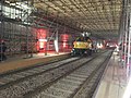
Combined solution construction site Durlacher Tor 2019


Combined solution construction site Lammstrasse 2020
Combined solution construction site Lammstrasse 2020

Combined solution construction site Lammstrasse 2020
Combined solution construction site Lammstrasse 2020


Web links
- Official project page including press reports on construction progress
- The combined solution in the Stadtwiki Karlsruhe including construction electronics and images
Individual evidence
- ↑ The following data from the urban railway tunnel section from the first processor largely from the plan approval documents and the like, the Stadtwiki. Retrieved May 1, 2013 . , Knowledge from the press etc.
- ↑ KASIG ( Memento of the original dated December 6, 2013 in the Internet Archive ) Info: The archive link was inserted automatically and has not yet been checked. Please check the original and archive link according to the instructions and then remove this notice. and ka-news from September 13, 2013 or BNN from September 14 and 28, 2013 for the 2 to 2.5 and 3 years
- ↑ Stadtzeitung from January 30, 2015 , and at ka-news savings plans for a combination solution: Will the market place stay track-free? and south branch on the market square: Empty shops from 2018? , all accessed on May 25, 2015.
- ↑ epd: Zeller Keramik Manufaktur produces Lüpertz works. Badische Zeitung, November 12, 2020, accessed on November 12, 2020 .
- Jump up ↑ Karlsruhe to experience art. Retrieved November 12, 2020 .
- ↑ Stefan Jehle: Markus Lüpertz presents the first "Genesis" ceramic in Karlsruhe. Badische Zeitung, December 29, 2020, accessed on January 4, 2021 .
- ↑ ka-news article: “Open construction site day”: 15,000 visitors flock to the Durlacher Tor . Retrieved November 14, 2014 .
- ↑ ka-news article: Combined solution: tunnel boring machine has been ordered - in 2014 it’s going underground . Retrieved August 8, 2013 .
- ↑ ka-news article: Combined solution: "Giulia" tunnel drill arrived at the Mühlburger Tor . Retrieved September 8, 2015 .
- ↑ Online newspaper article. ka-news, accessed on May 1, 2013 .
- ↑ Combined News: The fan worm "Giulia" is right here! ka-news.de, December 5, 2012, accessed December 10, 2014 .
- ↑ Here we go! (No longer available online.) KASIG - Karlsruhe Rail Infrastructure Society mbH, archived from the original on December 10, 2014 ; Retrieved December 10, 2014 . Info: The archive link was inserted automatically and has not yet been checked. Please check the original and archive link according to the instructions and then remove this notice.
- ↑ The following data from the urban railway tunnel section from the first processor largely from the development plan documents, etc., knowledge from the press, etc.
- ↑ BNN of September 21, 2020 , accessed on March 21, 2021.
- ↑ ka-news of April 9, 2014 , accessed April 10, 2014.
- ↑ old project website of the city, version during the election campaign ( memento of October 29, 2002 in the Internet Archive )
- ↑ competition page . City of Karlsruhe, accessed on May 1, 2013 .
-
↑ From the consideration of the variants of the plan approval decision. (PDF) Karlsruhe Regional Council, accessed on May 1, 2013 . : "2.4.1.6 Light rail tunnel with above-ground railway system in Kaiserstraße (pedestrian zone)"
This alternative involves leaving other lines above ground in Kaiserstraße in addition to the light rail tunnel. However, it should be remembered that the subject of the present plan approval procedure is only the component “Stadtbahntunnel Kaiserstraße with southern branch Ettlinger Straße”, but not the dismantling of the tracks in Kaiserstraße and the redesign of Kriegsstraße. The planning approval authority has to take into account realistic developments in the planning on which their decision is based, insofar as they can affect the measure to be determined. During the examination of the plan justification, however, the plan approval authority came to the conclusion that the "Stadtbahntunnel Kaiserstraße with southern branch Ettlinger Straße" is justified on its own for traffic as well as urban planning reasons, regardless of whether tracks remain above ground (so-called " Intermediate state ") or whether a further development takes place in the Kriegsstrasse. A final decision as to which of these two variants proves to be more advantageous in the result is therefore not required in the present proceedings. As a consequence, in any case in the present proceedings, the project sponsor cannot be obliged to continue to operate above-ground rail traffic in Kaiserstraße. The same applies, however, to a possible obligation to dismantle the above-ground track systems in Kaiserstraße. The planning approval authority therefore does not take up the proposal of the hearing authority, against the background of the decision of the referendum, in the plan approval decision, which obliges the developer to dismantle the rail system in Kaiserstraße at the request of the city of Karlsruhe. On the one hand, it is fundamentally not the task of the planning approval authority to ensure an internal decision-making process; on the other hand, due to its shareholder status, the city of Karlsruhe itself has to enforce a resolution it is responsible for. - ↑ Overview in the city wiki. Retrieved May 1, 2013 .
- ^ List in the Karlsruhe city wiki without Kaiser Wilhelm. Retrieved May 1, 2013 .
- ↑ Copy of the "conceivable line network". on a private website , accessed May 1, 2013 .
- ↑ see rough concept. City of Karlsruhe, accessed on May 1, 2013 .
- ↑ copy of Without Falls. (PDF; 31 kB) on a private website , accessed on May 1, 2013 .
- ↑ Line 9 in the city wiki. (No longer available online.) Archived from the original on March 2, 2013 ; Retrieved May 1, 2013 . Info: The archive link was inserted automatically and has not yet been checked. Please check the original and archive link according to the instructions and then remove this notice.
- ↑ Excerpts from the small one. Retrieved May 1, 2013 . and large information brochure. on a private website , accessed May 1, 2013 .
- ↑ All numbers of the chapter from the detailed city wiki page. Retrieved May 1, 2013 . which also names a large number of other sources.
- ↑ Online newspaper article. ka-news, accessed on May 1, 2013 .
- ↑ diekombiloesung.de
- ↑ swr.de
- ↑ Article in the Stuttgarter Zeitung and on ka-news: Are the federal subsidies on the brink? , "The project is not at risk" and refer Karlsruhe city council position , all accessed on May 25, 2015.
- ↑ From the grant notification at wikileaks, accessed on May 20, 2015 : "As a precaution, I would like to point out that in the event of a serious increase in costs there is a risk that the funding requirements will be withdrawn from the project in view of the short benefit-cost indicator" and If the costs ascertained during the examination of the application are exceeded or if one becomes necessary, a supplementary application with the documents necessary for its assessment must be submitted immediately . "
- ↑ From the Badische Neuesten Nachrichten of May 23, 2015: “As a consequence of the criticism of the Federal Audit Office of the costs of the combined solution […], according to Mayor Frank Mentrup, there is a risk of a possible delay in the award of the work on the road conversion work. This is currently running. In the meantime, the Federal Ministry of Transport has requested an 'overall assessment of the costs in a comprehensive framework', according to the OB. Before that, a decision could not be made about the commissioning of companies. [...] "
- ↑ Large information brochure on the referendum
- ↑ a b Submission to the municipal council on October 21, 2008.
- ^ Rupert Hustede: Bagger bite for car tunnel. In: Baden's latest news. April 21, 2017. Retrieved April 30, 2018 .
- ↑ Over 1.3 billion euros and the opening at the end of 2020 is also in jeopardy: The combined solution's schedule can hardly be met. In: ka-news. May 9, 2019. Retrieved August 28, 2019 .
- ↑ https://meinka.de/entendung-bestaetigt-gleise-kommen-raus-aus-der-kaiserstrasse/
- ↑ https://bnn.de/lokales/karlsruhe/die-u-strab-brauch-wohl-noch-ein-halbes-jaehrchen-mehr
- ↑ ka-news: Delay due to water damage: tram tunnel only goes into operation six months later | ka-news. July 2, 2020, accessed August 6, 2020 .
- ↑ Combined solution Karlsruhe: All information before the opening in 2021. March 26, 2021, accessed on September 5, 2021 .
- ↑ a b c d e f Previous studies on local public transport in Karlsruhe , City of Karlsruhe, Urban Planning Office, Aspects of Urban Planning, No. 21, January 1999.
- ↑ Unter Strom - history of local public transport in Karlsruhe , publisher: Badenia (2000), pp. 232–234.
- ↑ a b U-Strab in Karlsruhe , study on the possibilities of an underground tram in the city center, City of Karlsruhe, Mayor's Office Communications, No. 25, May 1989, Dec. IV
- ↑ from 89 study, revised summary according to " Vcfr " etc .: Combined solution history, section 1989. Stadtwiki Karlsruhe , accessed on May 1, 2013 .
- ↑ a b old project site of the city ( Memento from September 14, 2001 in the Internet Archive )
- ↑ a b Unofficial reproduction of the route networks 1997/2004/2014 can be found. on a private website , accessed May 1, 2013 . also alternative networks.
- ↑ Review 1996: Citizens' Decision. Voting result of the citizens' decision on the Kaiserstraße urban railway tunnel on October 20, 1996. City of Karlsruhe, accessed on May 21, 2015 .
- ^ From the interim report by DE-Consult, December 1996.
- ↑ a b c Submission for the municipal council meeting on October 23, 2001. (No longer available online.) City of Karlsruhe, archived from the original on February 5, 2008 ; Retrieved May 1, 2013 . Info: The archive link was inserted automatically and has not yet been checked. Please check the original and archive link according to the instructions and then remove this notice. , see also online newspaper article. ka-news, accessed on May 1, 2013 . and two articles in Kreisfairkehr 1/98. VCD Karlsruhe, accessed on May 1, 2013 .
- ↑ a b Unofficial summary of the meetings. on a private website , accessed May 1, 2013 .
- ↑ report in circular fairkehr 1/2002. VCD Karlsruhe, accessed on May 1, 2013 .
- ↑ Timetable on the old City2015 page ( Memento from June 4, 2002 in the Internet Archive )
- ↑ Timetable on the old City2015 page ( Memento from June 4, 2002 in the Internet Archive )
- ↑ Copy of the results table. on the BI website, accessed on May 1, 2013 .
- ↑ Data from the reports in the Greens circular 8 / 9-2002. (PDF; 836 kB) Archived from the original on August 21, 2014 ; Retrieved May 1, 2013 . and Kreisfairkehr 2/02. VCD Karlsruhe, accessed on May 1, 2013 . , Online newspaper article. ka-news, accessed on May 1, 2013 .
- ↑ Online newspaper article. ka-news, accessed on May 1, 2013 .
- ↑ Online newspaper article. ka-news, accessed on May 1, 2013 .
- ↑ Citizens' Decision City 2015 - official final results. (No longer available online.) City of Karlsruhe, Office for Urban Development - Electoral Office -, September 2002, archived from the original on April 29, 2010 ; accessed on May 21, 2015 . Info: The archive link was inserted automatically and has not yet been checked. Please check the original and archive link according to the instructions and then remove this notice.
- ↑ Overview of all networks. on a private website , accessed May 1, 2013 .
- ↑ Announcement in the city newspaper of December 30, 2005. City of Karlsruhe, accessed on May 1, 2013 .
- ↑ Article in the city newspaper. City of Karlsruhe, accessed on May 1, 2013 .
- ↑ From an answer to a state parliament request. (PDF; 53 kB) Ba-Wü, accessed on May 1, 2013 . , Funding notification at. Wikileaks, accessed May 1, 2013 .
- ↑ see website of the State Ministry of Transport. (No longer available online.) Archived from the original on November 4, 2012 ; Retrieved May 1, 2013 . Info: The archive link was inserted automatically and has not yet been checked. Please check the original and archive link according to the instructions and then remove this notice.
- ↑ The plan approval decision on the (PDF; 971 kB) regional council Karlsruhe, accessed on May 1, 2013 .
- ↑ Online newspaper article. ka-news, accessed on May 1, 2013 .
- ↑ page on the petition. on the petitioner's private website , accessed 1 May 2013 .
- ↑ Explanations in detail in the Stadtwiki Karlsruhe. Retrieved May 1, 2013 .
- ↑ Both reports with all components. on a private website , accessed May 1, 2013 .
- ↑ PM the. (No longer available online.) KASIG, archived from the original on July 21, 2014 ; Retrieved May 1, 2013 . Info: The archive link was inserted automatically and has not yet been checked. Please check the original and archive link according to the instructions and then remove this notice. and notification of the country. (No longer available online.) KASIG, archived from the original on April 2, 2013 ; Retrieved May 1, 2013 . Info: The archive link was inserted automatically and has not yet been checked. Please check the original and archive link according to the instructions and then remove this notice.
- ↑ Reply to the request. (PDF; 63 kB) Bundestag, accessed on May 1, 2013 . , see also another footnote in the city wiki
- ↑ Data from the city wiki. Retrieved May 1, 2013 .
- ↑ PM at the BvRK. Retrieved May 1, 2013 . and ka-news article on the bankruptcy of Alpine. Retrieved June 1, 2013 .
- ^ Salzburger Nachrichten on Insolvency. Retrieved June 19, 2013 .
- ^ Salzburger Nachrichten on the societies concerned. Retrieved June 19, 2013 . and ka-news article on the bankruptcy of Alpine. Retrieved June 19, 2013 .
- ^ Handelsblatt on the bankruptcy of Alpine Germany. Retrieved June 19, 2013 .
- ↑ ka-news article. Retrieved June 22, 2013 .
- ↑ ka-news article. Retrieved June 22, 2013 .
- ↑ ka-news article. Retrieved July 12, 2013 .
- ↑ Cavity under the pedestrian zone: trams in Karlsruhe run according to the replacement concept. (No longer available online.) Archived from the original on June 28, 2015 ; accessed on June 30, 2015 . Info: The archive link was inserted automatically and has not yet been checked. Please check the original and archive link according to the instructions and then remove this notice. , Press release on the combined solution
- ↑ The cavity under Kaiserstraße was created at a critical point - the tracks are expected to be closed by the middle of next week. (No longer available online.) Archived from the original on July 5, 2015 ; accessed on June 30, 2015 . Info: The archive link was inserted automatically and has not yet been checked. Please check the original and archive link according to the instructions and then remove this notice. , Press release on the combined solution
- ↑ Cavity: renovation under Kaiserstraße completed. (No longer available online.) Archived from the original on July 1, 2015 ; accessed on June 30, 2015 . Info: The archive link was inserted automatically and has not yet been checked. Please check the original and archive link according to the instructions and then remove this notice. , Press release on the combined solution
- ↑ Rail operations in Kaiserstraße will start very early tomorrow - work on cutting “Giulia” continues. (No longer available online.) Archived from the original on July 8, 2015 ; Retrieved July 8, 2015 . Info: The archive link was inserted automatically and has not yet been checked. Please check the original and archive link according to the instructions and then remove this notice. , Press release on the combined solution
- ↑ Federal Audit Office says "No" to the war road tunnel. In: ka-news.de. May 3, 2016. Retrieved September 19, 2016 .
- ↑ a b Start of construction of the tram route in Karlsruhe. Ministry of Transport Baden-Wuerttemberg, April 21, 2017, accessed on May 23, 2017 .
- ↑ https://www.diekombiloesung.de/aktuelles/presseinformationen/vergleich/erstmals-testfahrt-einer-strassenbahn-im-kombiloesungs-tunnel.html
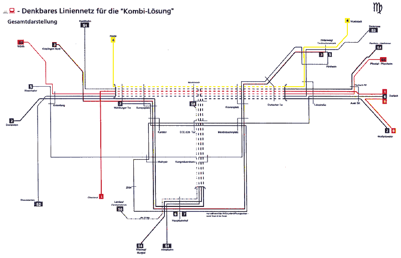
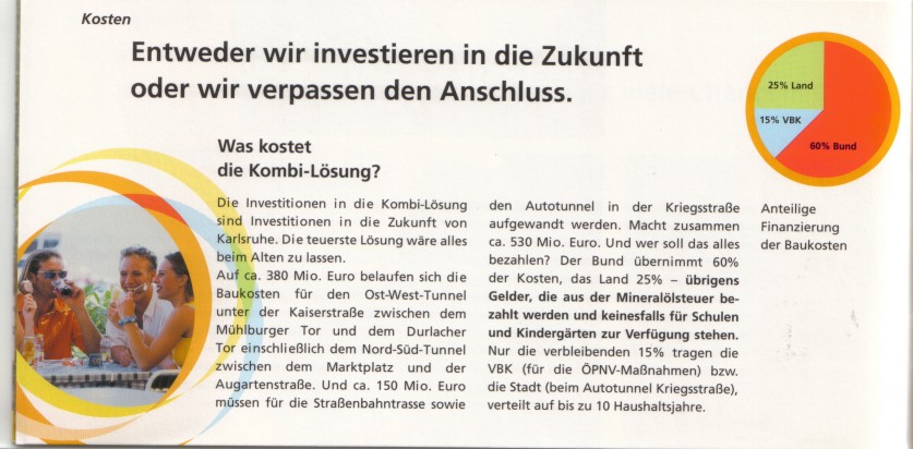
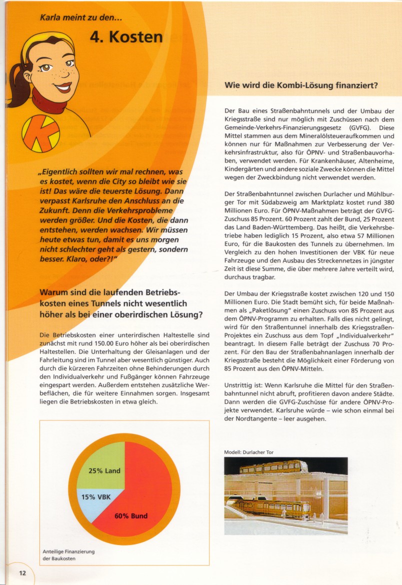