Admiralty Island
| Admiralty Island National Monument | ||
|---|---|---|
| Windfall harbor, a natural harbor on the island | ||
|
|
||
| Location: | Alaska , United States | |
| Specialty: | Island with boreal forest and the highest density of brown bears in North America | |
| Next city: | Angoon | |
| Surface: | 4264 km² | |
| Founding: | December 1, 1978 | |
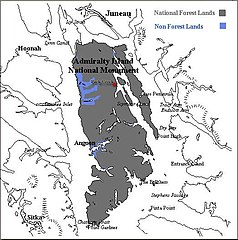
Admiralty Island is an island in the Alexander Archipelago in the southeast of the US state Alaska . It belongs to the ABC islands of Alaska and is located roughly in the middle of the archipelago between the cities of Sitka and Juneau . The island is 164 km long and 48 km wide and covers an area of 4264 km². According to the 2000 census, 650 people live on the island. The Tlingit community of Angoon with 572 inhabitants is the only permanent settlement on the island. 265 km² (6.2%) in the northern part of the island are uninhabited and belong to the city of Juneau. The highest point on the island is Eagle Peak ( 1395 m ).
The name Admiralty Island was given by British explorers, Russian fur hunters named the island Ostrow Kutsnoi (Island of Fear) because of the many brown bears .
Flora and fauna
The island is called Kootznoowoo (Bear Fortress) by the local Tlingit people . Admiralty Island has the densest brown bear population in North America with around 1700 animals. The bears are best seen at Park Creek, where they catch salmon from the fast-flowing river in late summer and fall . The island is almost completely forested, the main species are the Sitka spruce and the West American hemlock . Deciduous trees also grow in protected areas, and tundras can be found at higher altitudes in the center of the island . Around 5000 bald eagles and the Sitka black- tailed deer live on the island. Seals , Steller sea lions and humpback whales , as well as various species of sea ducks such as scoter and collar duck live in the coastal waters .
Conservation and Tourism
The island is part of the multi-island Tongass National Forest , a national forest managed by the US Forest Service . The only exception is the settlement area of Angoon. 3865 km², most of the island, has formed the Admiralty Island National Monument since 1978 , a nature reserve of the type of a national monument . 3793 km² (almost the entire island except the northern tip) were also placed under the further protection of a wilderness area in 1980 as Kootznoowoo Wilderness . There are no roads or buildings in the wilderness areas (apart from a few huts that were already under protection and rented out by the Forest Service), and hiking trails are maintained. Trekking and canoeing are the only permitted forms of transportation, vehicles of all kinds (including mountain bikes ) are prohibited. Fishing and hunting are permitted within the framework of legal regulations.
The Admiralty Island Canoe Route through the island is interesting for canoeists , eight large lakes are connected by portages on boardwalks.
Industry
In the north of the island, the Greens Creek mine , one of the largest silver - mines in the world. When the island was placed under protection, exploratory bores were already in progress, and the continuation of exploration, expansion and operation from 1987/89 onwards were therefore permitted in the protected area. In 2007, the Greens Creek mine produced around 245 tons of silver as well as 2 tons of gold , 63,000 tons of zinc and 21,000 tons of lead as by-products . This makes it the fifth largest silver mine in the world.
Web links
- USFS: Admiralty National Monument (official site) (English)
- Wilderness.net: Kootznoowoo Wilderness
- Friends of Admiralty - Site of a coalition of conservationists in the region
- Nature Conservancy: Admiralty Island
Individual evidence
- ↑ businesswire.com: Hecla Acquires 70.3% of Greens Creek Mine for $ 750 million , February 12, 2008


