Agno (Gulf of Lingayen)
| Agno | ||
| Data | ||
| location | Luzon Island ( Philippines ) | |
| River system | Agno | |
| source |
Mt. Data 16 ° 48 ′ 48 ″ N , 120 ° 53 ′ 24 ″ E |
|
| Source height | 2090 m | |
| muzzle | in the Gulf of Lingayen Coordinates: 16 ° 2 ′ 17 ″ N , 120 ° 12 ′ 0 ″ E 16 ° 2 ′ 17 ″ N , 120 ° 12 ′ 0 ″ E
|
|
| length | 205 km | |
| Catchment area | 5952 km² | |
| Right tributaries | Tarlac | |
| Reservoirs flowed through | San Roque Dam , Binga Dam , Ambuklao Dam | |
| Big cities | Bayambang | |
| Medium-sized cities | Lingayén , Alcala , Santa Maria | |
|
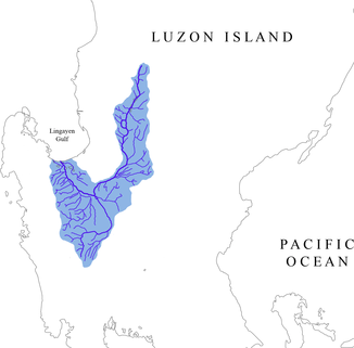
Catchment area of the Agno |
||
The Agno is a 205 km long river in the north of the Philippine island of Luzon .
It rises in the province of Benguet , about 10 km north of Kabayan . The headwaters are on Mt. Data in the Philippine Cordilleras at an altitude of 2090 m . The rivers Chico and Abra also have their source just a few kilometers north .
The Agno flows south from the beginning. It is the fifth longest river in the Philippines and the third longest river on the island of Luzon. The Agno has a catchment area of approx. 5952 km². After 17 km he reaches the Ambuklao lake . In the vicinity of Urdaneta it begins to flow in a south-westerly direction and then changes its course completely to the west after a further kilometer. Its main tributary is the Tarlac , which has its source at Pinatubo in the Zambales Mountains . Only from Aguilar it flows north and empties a few kilometers later in the Lingayen Gulf in the same municipality Lingayen .
The Agno is dammed at San Manuel and San Nicolas in the San Roque dam .


