San Nicolas (Pangasinan)
| Municipality of San Nicolas | ||
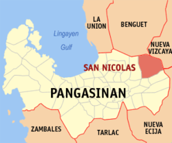
| Location of San Nicolas in the Pangasinan Province | ||
|---|---|---|

|
||
| Basic data | ||
| Region : | Ilocos region | |
| Province : | Pangasinan | |
| Barangays : | 33 | |
| District: | 6. District of Pangasinan | |
| PSGC : | 015536000 | |
| Income class : | 3rd income bracket | |
| Households : | 6533 May 1, 2000 census
|
|
| Population : | 35,574 August 1, 2015 census
|
|
| Population density : | 171 inhabitants per km² | |
| Area : | 208 km² | |
| Coordinates : | 16 ° 4 ′ N , 120 ° 46 ′ E | |
| Postal code : | 2447 | |
| Area code : | +63 75 | |
| Mayor : | Leoncio III S. Saldivar | |
| Geographical location in the Philippines | ||
|
|
||
San Nicolas is a municipality in the Philippine province of Pangasinan . It borders the provinces of Benguet and Nueva Vizcaya to the north and east . In 2015, 35,574 people lived in the 208 km² area, resulting in a population density of 171 inhabitants per km². As in the neighboring community of San Manuel , most of the residents live in the flat south of the area. In the north and east the terrain rises sharply due to the Filipino Cordilleras . Part of the San Roque Dam also belongs to San Nicolas . The municipality was founded in 1800 by Nicolas Patricio y Mejia and named after him.
Administrative division
San Nicolas is divided into the following 33 barangays :
|
|
|
Note: Población (Spanish for population) refers to several barangays in the center of a municipality in the Philippines.
