Santo Tomas (Pangasinan)
| Municipality of Santo Tomas | ||
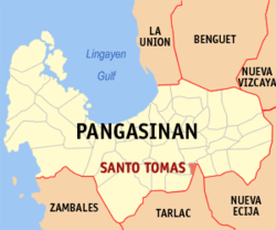
| Location of Santo Tomas in the Pangasinan Province | ||
|---|---|---|

|
||
| Basic data | ||
| Region : | Ilocos region | |
| Province : | Pangasinan | |
| Barangays : | 10 | |
| District: | 5. District of Pangasinan | |
| PSGC : | 015540000 | |
| Income class : | 5th income bracket | |
| Households : | 2716 May 1, 2000 census
|
|
| Population : | 15,022 August 1, 2015 census
|
|
| Population density : | 1050 inhabitants per km² | |
| Area : | 14.3 km² | |
| Coordinates : | 15 ° 43 ′ N , 120 ° 35 ′ E | |
| Postal code : | 2426 | |
| Area code : | +63 75 | |
| Mayor : | Vivien O. Villar | |
| Geographical location in the Philippines | ||
|
|
||
Santo Tomas is a borough in the Filipino
Pangasinan Province and borders to the east with Tarlac Province . In 2015, 15,022 people lived in an area of just 14.3 km², resulting in a population density of 1050 people per km².
Santo Tomas is divided into the following ten barangays :
- La Luna
- Poblacion East
- Poblacion West
- Salvacion
- San Agustin
- San Antonio
- San Jose
- San Marcos
- Santo Domingo
- Santo Niño
