Santa Barbara (Pangasinan)
| Municipality of Santa Barbara | ||
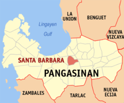
| Location of Santa Barbara in the Pangasinan Province | ||
|---|---|---|

|
||
| Basic data | ||
| Region : | Ilocos region | |
| Province : | Pangasinan | |
| Barangays : | 29 | |
| District: | 3. District of Pangasinan | |
| PSGC : | 015538000 | |
| Income class : | 1st income bracket | |
| Households : | 12.111 May 1, 2000 census
|
|
| Population : | 82.012 August 1, 2015 census
|
|
| Population density : | 1252 inhabitants per km² | |
| Area : | 65.48 km² | |
| Coordinates : | 16 ° 0 ′ N , 120 ° 24 ′ E | |
| Postal code : | 2419 | |
| Mayor : | Reynaldo V. Velasco | |
| Website: | http://pangasinan.org/santabarbara/ | |
| Geographical location in the Philippines | ||
|
|
||
Santa Barbara is a municipality in the Philippine province of Pangasinan on the island of Luzon and is located in the extensive river basin of the Agno . In 2015, 82,012 people lived in the 65.48 km² area, resulting in a population density of 1252 inhabitants per km². The majority of the population lives from agriculture.
Santa Barbara is divided into the following 29 barangays (districts):
|
|
|
Web links
Commons : Santa Barbara, Pangasinan - collection of pictures, videos and audio files

