Manaoag
| Municipality of Manaoag | ||
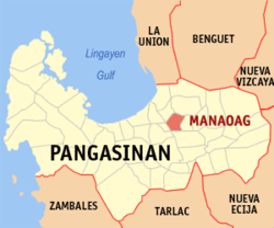
| Location of Manaoag in the Pangasinan Province | ||
|---|---|---|

|
||
| Basic data | ||
| Region : | Ilocos region | |
| Province : | Pangasinan | |
| Barangays : | 26th | |
| District: | 4. District of Pangasinan | |
| PSGC : | 015525000 | |
| Income class : | 2nd income bracket | |
| Households : | 10,563 May 1, 2000 census
|
|
| Population : | 69,497 August 1, 2015 census
|
|
| Population density : | 1216 inhabitants per km² | |
| Area : | 57.16 km² | |
| Coordinates : | 16 ° 3 ′ N , 120 ° 29 ′ E | |
| Postal code : | 2430 | |
| Area code : | +63 75 | |
| Mayor : | Napoleon D. Sales | |
| Geographical location in the Philippines | ||
|
|
||
Manaoag is a municipality in the Philippine province of Pangasinan . In 2015, 69,497 people lived in the 57.16 km² area, resulting in a population density of 1216 inhabitants per km². The parish was founded in 1600 by the Augustinians .
The Rosary Basilica is a protected cultural asset.
Manaoag is divided into the following 26 barangays :
|
|

