Pozorrubio
| Municipality of Pozorrubio | ||
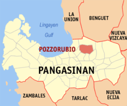
| Location of Pozorrubio in the Pangasinan Province | ||
|---|---|---|

|
||
| Basic data | ||
| Region : | Ilocos region | |
| Province : | Pangasinan | |
| Barangays : | 34 | |
| District: | 5. District of Pangasinan | |
| PSGC : | 015530000 | |
| Income class : | 2nd income bracket | |
| Households : | 11,288 May 1, 2000 census
|
|
| Population : | 69,555 August 1, 2015 census
|
|
| Population density : | 775.9 inhabitants per km² | |
| Area : | 89.65 km² | |
| Coordinates : | 16 ° 7 ′ N , 120 ° 33 ′ E | |
| Postal code : | 2435 | |
| Area code : | +63 75 | |
| Geographical location in the Philippines | ||
|
|
||
Pozorrubio (the former Claris or Pozzorrubio ) is a municipality in the Philippine province of Pangasinan . In 2015, 69,555 people lived in the 89.65 km² area, resulting in a population density of 776 inhabitants per km². The mostly flat terrain borders on the Filipino Cordilleras .
Pozorrubio in the following 34 barangays divided:
|
|
|
Note: Población (Spanish for population) often refers to several barangays in the center of a municipality in the Philippines.


