
The oil
| Municipality of Dasol | |||
| Location of Dasol in the Pangasinan Province | |||
|---|---|---|---|

|
|||
| Basic data | |||
| Region : | Ilocos region | ||
| Province : | Pangasinan | ||
| Barangays : | 18th | ||
| District: | 1. District of Pangasinan | ||
| PSGC : | 015519000 | ||
| Income class : | 4. Income bracket | ||
| Households : | 5092 May 1, 2000 census
|
||
| Population : | 29,110 August 1, 2015 census
|
||
| Population density : | 174.7 inhabitants per km² | ||
| Area : | 166.6 km² | ||
| Coordinates : | 15 ° 59 ′ N , 119 ° 53 ′ E | ||
| Postal code : | 2411 | ||
| Area code : | +63 75 | ||
| Mayor : | Noel A. Nacar | ||
| Website: | The oil | ||
| Geographical location in the Philippines | |||
|
|||

Dasol is a municipality in the Philippines in the Pangasinan Province and is located on the South China Sea . In 2015, 29,110 people lived in the 166.6 km², partly hilly area, which results in a population density of 175 inhabitants per km². Dasol was founded in 1911. The current mayor is Angelita O. Jimenez.
economy
An important branch of the economy in the municipality is the salt production with the help of seawater salines . Sea water is fed into the artificially created salt marshes, where it evaporates. Then the salt is harvested. There are a total of 14 salt producers in Dasol. The entire Dasol Bay is managed in this way. The people also live from agriculture and fishing. Despite the beautiful beaches, hardly any tourists come to the community.
- Pictures from Dasol
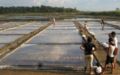
Saline in Dasol
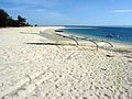
Beach in Tambobong

Dasol Bay


Barangays
Dasol is divided into the following 18 barangays :
|

Web links
- www.dasolpangasinan.com ( Memento from April 2, 2007 in the Internet Archive )