Binmaley
| Municipality of Binmaley | ||
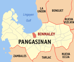
| Location of Binmaley in the Pangasinan Province | ||
|---|---|---|

|
||
| Basic data | ||
| Region : | Ilocos region | |
| Province : | Pangasinan | |
| Barangays : | 33 | |
| District: | 2. District of Pangasinan | |
| PSGC : | 015513000 | |
| Income class : | 2nd income bracket | |
| Households : | 13,415 May 1, 2000 census
|
|
| Population : | 83.052 August 1, 2015 census
|
|
| Population density : | 1357 inhabitants per km² | |
| Area : | 61.2 km² | |
| Coordinates : | 16 ° 2 ′ N , 120 ° 16 ′ E | |
| Postal code : | 2417 | |
| Area code : | +63 75 | |
| Geographical location in the Philippines | ||
|
|
||
Binmaley is a municipality in the Philippine province of Pangasinan and is located on the Gulf of Lingayen . Most of the people live from fishing and rice cultivation. The flat, moist terrain is particularly suitable for growing rice. There is a Pangasinan State University campus in the community .
Binmaley is divided into the following 33 barangays :
|
|
|

