San Fabian
| Municipality of San Fabian | ||
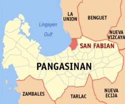
| Location of San Fabian in the Pangasinan Province | ||
|---|---|---|

|
||
| Basic data | ||
| Region : | Ilocos region | |
| Province : | Pangasinan | |
| Barangays : | 34 | |
| District: | 4. District of Pangasinan | |
| PSGC : | 015533000 | |
| Income class : | 2nd income bracket | |
| Households : | 12,690 May 1, 2000 census
|
|
| Population : | 83.025 August 1, 2015 census
|
|
| Population density : | 1021 inhabitants per km² | |
| Area : | 81.3 km² | |
| Coordinates : | 16 ° 9 ′ N , 120 ° 27 ′ E | |
| Postal code : | 2433 | |
| Area code : | +63 75 | |
| Mayor : | Mojamito R. Libunao | |
| Website: | San Fabian | |
| Geographical location in the Philippines | ||
|
|
||
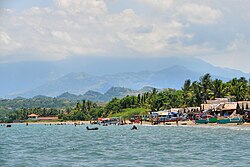
San Fabian is a municipality in the province of Pangasinan on the Philippine island of Luzon directly on the Gulf of Lingayen . In 2015, a total of 83,025 people lived in the flat and 81.3 km² area, resulting in a population density of 1021 inhabitants per km². The community was founded by Dominicans and named after Pope Fabianus . On the gray sandy beaches there are several hotels with international clients right by the sea.
San Fabian is divided into the following 34 barangays :
|
|
|


