Urdaneta (Pangasinan)
| City of Urdaneta | ||
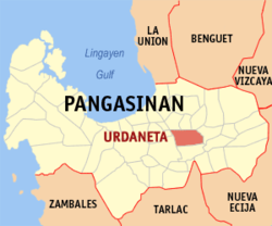
| Location of Urdaneta in the Pangasinan Province | ||
|---|---|---|

|
||
| Basic data | ||
| Region : | Ilocos region | |
| Province : | Pangasinan | |
| Barangays : | 34 | |
| District: | 5. District of Pangasinan | |
| PSGC : | 015546000 | |
| Income class : | 2nd income bracket | |
| Households : | 22,908 May 1, 2000 census
|
|
| Population : | 132,940 August 1, 2015 census
|
|
| Population density : | 1099 inhabitants per km² | |
| Area : | 121.00 km² | |
| Coordinates : | 15 ° 59 ′ N , 120 ° 34 ′ E | |
| Postal code : | 2428 | |
| Area code : | +63 75 | |
| Mayor : | Amadeo R. Perez Jr. | |
| Website: | www.urdaneta-city.gov.ph | |
| Geographical location in the Philippines | ||
|
|
||
Urdaneta is a city in the Philippine province of Pangasinan . The city, which is on one level, was only founded in 1858 and there is a campus of the Pangasinan State University in the community .
Urdaneta is the seat of the Urdaneta diocese .
Urdaneta is divided into the following 34 barangays :
|
|
|
