Balungao
| Municipality of Balungao | ||
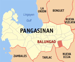
| Location of Balungao in the Pangasinan Province | ||
|---|---|---|

|
||
| Basic data | ||
| Region : | Ilocos region | |
| Province : | Pangasinan | |
| Barangays : | 20th | |
| District: | 6. District of Pangasinan | |
| PSGC : | 015507000 | |
| Income class : | 4. Income bracket | |
| Households : | 5102 May 1, 2000 census
|
|
| Population : | 31,106 August 1, 2015 census
|
|
| Population density : | 330.9 inhabitants per km² | |
| Area : | 94 km² | |
| Coordinates : | 15 ° 54 ′ N , 120 ° 42 ′ E | |
| Postal code : | 2442 | |
| Area code : | +63 75 | |
| Geographical location in the Philippines | ||
|
|
||
Balungao is a municipality in the Philippine province of Pangasinan . In the south it borders on the province of Nueva Ecija . The terrain is mostly flat; only a few small volcanoes rise from the landscape, such as Mt. Balungao, which is named after the place, at 382 meters.
Balungao is divided into the following 20 barangays :
|
|
