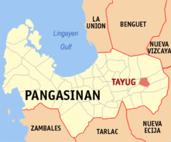
Tayug
| Municipality of Tayug | ||
| Location of Tayug in the Pangasinan Province | ||
|---|---|---|

|
||
| Basic data | ||
| Region : | Ilocos region | |
| Province : | Pangasinan | |
| Barangays : | 21st | |
| District: | 6. District of Pangasinan | |
| PSGC : | 015543000 | |
| Income class : | 3rd income bracket | |
| Households : | 7479 May 1, 2000 census
|
|
| Population : | 43,149 August 1, 2015 census
|
|
| Population density : | 841.1 inhabitants per km² | |
| Area : | 51.3 km² | |
| Coordinates : | 16 ° 2 ′ N , 120 ° 45 ′ E | |
| Postal code : | 2445 | |
| Area code : | +63 75 | |
| Mayor : | Carlos Trece Romero Mapili | |
| Geographical location in the Philippines | ||
|
|
||
Tayug is a municipality in the Philippine province of Pangasinan .
The rivers Agno and Cabitongan flow through the municipality, which lies in a plain . As in most parts of Pangasinan, agriculture is the main source of income.
Barangays
Tayug is in the following 21 barangays divided:
|
|
