Mangatarem
| Municipality of Mangatarem | ||
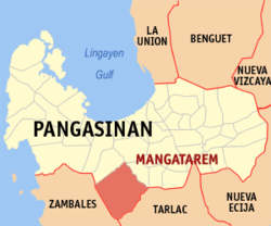
| Location of Mangatarem in the Pangasinan Province | ||
|---|---|---|

|
||
| Basic data | ||
| Region : | Ilocos region | |
| Province : | Pangasinan | |
| Barangays : | 82 | |
| District: | 2. District of Pangasinan | |
| PSGC : | 015527000 | |
| Income class : | 2nd income bracket | |
| Households : | 11,704 May 1, 2000 census
|
|
| Population : | 73.241 August 1, 2015 census
|
|
| Population density : | 226.8 inhabitants per km² | |
| Area : | 323 km² | |
| Coordinates : | 15 ° 47 ′ N , 120 ° 18 ′ E | |
| Postal code : | 2413 | |
| Area code : | +63 75 | |
| Geographical location in the Philippines | ||
|
|
||
Mangatarem is a municipality in the Philippine province of Pangasinan . It borders on the province of Zambales in the southwest and Tarlac in the southeast . In 2015, 73,241 people lived in the 323 km² area, resulting in a population density of 227 inhabitants per km². The community was founded in 1827 by Dominicans . Here, too, agriculture is the most important industry.
Mangatarem is in a total of 82 barangays divided.
