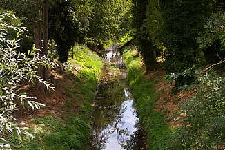
Alpe (Aller)
| Alp | ||
|
The Alpe in Rethem (Aller) |
||
| Data | ||
| location | Lower Saxony , Germany | |
| River system | Weser | |
| Drain over | Aller → Weser → North Sea | |
| source | Southwest of Dudensen 52 ° 35 ′ 34 ″ N , 9 ° 25 ′ 12 ″ E |
|
| Source height | 46 m above sea level NHN | |
| muzzle | In Rethem in the Aller coordinates: 52 ° 47 ′ 19 ″ N , 9 ° 23 ′ 1 ″ E 52 ° 47 ′ 19 ″ N , 9 ° 23 ′ 1 ″ E |
|
| Mouth height | 18 m above sea level NHN | |
| Height difference | 28 m | |
| Bottom slope | 0.95 ‰ | |
| length | 29.6 km | |
| Catchment area | 257 km² | |
| Discharge at the Frankenfelderbruch A Eo gauge : 162 km² Location: 8.2 km above the estuary |
NNQ (25 Aug 1989) MNQ 1961–2012 MQ 1961–2012 Mq 1961–2012 MHQ 1961–2012 HHQ (13 Feb 1962) |
99 l / s 310 l / s 1.15 m³ / s 7.1 l / (s km²) 5.2 m³ / s 11.5 m³ / s |
| Outflow A Eo : 257 km² |
MQ Mq |
1.85 m³ / s 7.2 l / (s km²) |
| Left tributaries | Old peat moat, Laderholzer Moorgraben, Steimbker Dorfgraben, Moorbeeke, Alpengraben, Wölpe | |
| Right tributaries | Lutterer Bach, Neuer Eilter Graben, Schotengraben | |
| Small towns | Rethem | |
| Communities | Dudensen , loader wood | |
The Alpe is a roughly 30 km long left or southern tributary of the Aller in Lower Saxony ( Germany ). Their catchment area lies at the confluence of the Weser and Aller.
course
The headwaters of the Alpe are located in a flat, undulating Geest area south of the Aller- Urstromtal in the area of the town of Neustadt am Rübenberge , also called Mühlenfelder Land . The alp itself rises from the western edge of the Dudenser Moorsenke. The ditch that opens there after a kilometer from the left comes from a valley that only carries water in parts, which is a good three kilometers longer than that of the Alpe. Its narrow catchment area begins at the highest point of the Alpe catchment area, the 106 m high Hüttenberg in the Grinderwald . The wide valley of the Alpe facing north-east narrows somewhat and is sunk about 20 meters deep into the surrounding ground moraine plateau between Bevensen and Laderholz .
After emerging in the Talsandebene the all-glacial valley the Alp takes the northwest direction of flow from the right opens Lutterer stream and thus follows a valley line parallel to the south edge of the glacial valley that in the penultimate glacial as an earlier of several courses of the east adjacent line arose . Then the alp turns north and is accompanied for 10 kilometers in the east by the street village Rodewald . The large Lichtenmoor borders to the west .
At Lichtenhorst it swings almost to the north-west of the New Eilter Trench, which opens from the right, and thus follows the course of the Aller during the ice age . In its last section, running north again, the Alpe forms the border between the Rethem-Moor lowland in the west and the Schotenheide valley sand plain in the east.
On the southern outskirts of Rethem (Aller) , the Alpe is directed over the White Graben to the west to the smaller Wölpe , which has thus become the Alpe's largest tributary. This watercourse, called the Alpe-Wölpe floodwater, is primarily used to protect Rethem from flooding. Before the diversion, the Alpe flowed through the old town of Rethem and there it flowed into the Aller. Today the estuary is 1.5 kilometers further northwest in the Wohlendorf district. This measure increased the catchment area of the Alpe from almost 200 km² to 257 km², and the mean water flow from a good 1.3 m³ / s to more than 1.8 m³ / s.
Ecological aspects
In the 1970s, the Alpe was straightened and, for the most part, also channeled. The river has good water quality over its entire course (quality class II = moderately polluted). The Steimbker Dorfgraben, which flows in from the left, is heavily polluted (quality class III – IV).
Individual evidence
- ↑ a b List of areas for the Lower Saxony hydrographic map, updated on July 13, 2010 (251.63 km²), corrected for the upper Schipsegraben, which today is fed to the Wölpe and thus the Alpe (5.5 km²)
- ↑ a b runoff values of the levels Frankenfelder fraction (Alp) and Anderten (Wölpe), increased by the outflow from the rest of the catchment area (43.8 square kilometers), determined from the area of outflow of the intermediate basin, the level Rethem , Frankenfelder fraction , Anderten , Lehringen , Weitz mills , Doerverden and Intschede (6.3 l / s km²)
- ↑ NLWKN water quality of the Alps
