Altenburg (Spessart)

The Altenburg is a prehistoric fortification in the Spessart between the localities Soden (district of Sulzbach am Main ) and Ebersbach (district of Leidersbach ) in the Lower Franconian district of Miltenberg on the hilltop of the Schlossberg . It is 365 meters long in east-west direction and 180 meters wide in north-south direction. Today a double ring wall can still be seen that surrounds the summit plateau of the mountain.
history
In the 19th and early 20th centuries, the building was badly affected by the demolition of stones that were needed for building projects in the surrounding villages. In particular, the remains of the square tower / building on the east side were completely removed.
At the time of the Kingdom of Bavaria , the building was dated to the urn field culture around 1000 BC. Later approaches spoke in favor of using the facility as a refuge in the early Middle Ages .
In 2008 and 2009 the Archaeological Spessart Project (ASP) carried out excavations on the Altenburg site. The aim of the excavations was to determine how old the facility is, which phases of use are verifiable and how the imposing ramparts were originally constructed. The following phases are archaeologically verifiable:
1st phase: Dated to the time of the Michelsberg culture (approx. 4400-3500 BC). Some ceramic fragments typical of this culture date from this period. Since no further settlement remains could be found, no further statements can be made about this phase. For example, it is unclear how big the settlement was, where exactly it was on the site, or whether previous buildings of the ramparts existed at that time.
2nd phase: transition between Hallstatt and Latène times . During the excavation work, massive layers of charcoal came to light in the inner wall of the complex. These layers were the remains of charred oak beams that were originally built into the wall. The remains of wood could be dated using the radiocarbon method and dendrochronology . The examination of the still-preserved annual rings of a beam showed that the tree from which the wood came did not exist before the year 613 BC. Was beaten. A more precise chronological classification was not possible due to the poor state of preservation. The results of the radiocarbon analysis point to the period around 450 BC. BC. The inner wall was probably the fallen remains of a post slit wall .
3rd phase: Since the fall layers of the inner wall run under the outer bering, it must be assumed that the outer wall was built after the inner wall was destroyed. However, an exact dating of the outer ring is not possible due to a lack of finds.
The grounds of Altenburg are severely disturbed by the quarry work mentioned in the 19th and early 20th centuries, robbery graves and treasure hunters, as well as maneuvers by the US armed forces after the Second World War . This complicates the archaeological investigation of the facility or makes it impossible in places. It is therefore not possible to make any statements about interior development.
It should be noted that the Altenburg was built around 600-450 BC. BC was a Celtic fortification that was supposed to control the trade routes in the region and, due to its exposed location, certainly also served representative purposes.
Others
As is usually the case with old systems, there are also several sagas and legends about the Altenburg . The best known is the one about the “Aleborgfraale”, which is supposed to guard an old treasure that can only be found on the night before St. John's Day by those who do not speak a word during the treasure hunt .
reconstruction
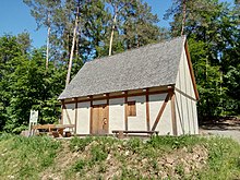
Following the archaeological investigations, the Sulzbach and Leidersbach historical societies rebuilt a multi-meter long post slot wall on the Altenburg site. In addition, a 'Celtic House' was built in which life on the Altenburg was recreated for visitors. In addition, several information boards have been set up.
literature
- (Ed.) HGV Sulzbach and Leidersbach, Harald Rosmanitz: The Altenburg between Sulzbach and Leidersbach. A prehistoric rampart between the Main and Spessart , Verlagdruckerei Schmidt, Neustadt ad Aisch 2012, ISBN 978-3-87707-849-5 .
- Klaus Schwarz: The Altenburg, also called Sodenburg . In: Guide to prehistoric and early historical monuments , Volume 8, Mainz 1967, pp. 159–169
- Wolfgang Hartmann: "... who owns the old castles" On the medieval history of Altenburg in West Spessart , Spessart 01/2013, pp. 23-27
Web links
- The Altenburg near Sulzbach / Leidersbach - The archaeological research of a prehistoric ring wall , website of the Archaeological Spessart Project (ASP)
- Altenburg - The archaeological research of a prehistoric ring wall , website of the market Sulzbach a.Main
- Sulzbach Altenburg - history and archeology: From earthworks to military training areas , website of the Spessart and Odenwald castle landscape
Individual evidence
- ↑ See on this: Endrich, Peter: Pre- and early history of the Bavarian Untermaing area . Aschaffenburg 1961, page 111.
- ↑ See: Schwarz, Klaus: Die Altenburg, also called Sodenburg. In: Guide to Prehistoric and Protohistoric Monuments. Tape. 8 Ed .: Römisch-Germanisches Zentralmuseum Mainz, Mainz 1967, pages 159–169.
- ↑ Cf. on this: Gergely Kápolnási, Harald Rosmanitz: The Altenburg - a little explored ring wall in the Spessart . In: Markus Marquart (ed.): KeltenLand am Fluss. The Celts in the Rhine-Main Area , Rahden 2010, pages 65–68.
- ^ The Altenburg - sagas: Vom Aleborgfraale and von Knabenräubern , website of the Archaeological Spessart Project (ASP); accessed on September 20, 2017
Coordinates: 49 ° 55 '3.62 " N , 9 ° 12' 45.92" O


