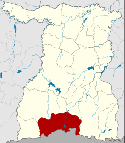
Cape Choeng district
|
Cape Choeng กาบเชิง |
|
|---|---|
| Province: | Surin |
| Surface: | 574.0 km² |
| Residents: | 60,507 (2013) |
| Population density : | 107 U / km² |
| ZIP : | 32210 |
| Geocode : | 3206 |
| map | |

|
|
Amphoe Cape Choeng ( Thai : อำเภอ กาบเชิง ) is a district ( Amphoe - administrative district) in the south of Surin Province . The province of Surin is located in the northeast region of Thailand , the so-called Isan .
geography
Neighboring districts are (clockwise from the west): the Amphoe Phanom Dong Rak , Prasat and Sangkha of Surin Province, Oddar Meancheay in Cambodia .
There is a border crossing to Cambodia at the Chong Chom Pass.
history
The place Ban Kap Choeng is about 200 years old. He originally belonged to the Tambon Dan in the Amphoe Sangkha. In 1937 the administration was transferred to the Tambon Nong Yai in Prasat district. In 1964 the Tambon Cape Choeng was established. On May 25, 1975 the Tambon Cape Choeng and Ban Dai were combined into a "branch circle" ( King Amphoe ) . Tambon Khok Klang was added in 1976, Tambon Dan and Khu Tan in 1977. Cape Choeng received full amphoe status on March 20, 1979.
Attractions
administration
Provincial Administration
The district of Cape Choeng is divided into six tambon ("subdistricts" or "communities"), which are further subdivided into 86 muban ("villages").
| No. | Surname | Thai | Muban | Pop. |
|---|---|---|---|---|
| 1. | Cape Choeng | กาบเชิง | 20th | 15,100 |
| 4th | Khu Tan | คู ตัน | 10 | 5,605 |
| 5. | Dan | ด่าน | 18th | 12,239 |
| 6th | Naeng courage | แน ง มุด | 15th | 10,923 |
| 7th | Khok Takhian | โคก ตะเคียน | 14th | 11,518 |
| 10. | Takhian | ตะเคียน | 9 | 5.122 |
The missing numbers (geocodes) belonged to tambons, which now belong to the Amphoe Phanom Dong Rak .
Local administration
There are two municipalities with "small town" status ( Thesaban Tambon ) in the district:
- Cape Choeng (Thai: เทศบาล ตำบล กาบเชิง ), consisting of the entire tambon Cape Choeng.
- Khok Takhian (Thai: เทศบาล ตำบล โคก ตะเคียน ), consisting of the entire tambon Khok Takhian.
There are also four " Tambon Administrative Organizations " ( องค์การ บริหาร ส่วน ตำบล - Tambon Administrative Organizations, TAO):
- Khu Tan (Thai: องค์การ บริหาร ส่วน ตำบล คู ตัน )
- Dan (Thai: องค์การ บริหาร ส่วน ตำบล ด่าน )
- Naeng Mut (Thai: องค์การ บริหาร ส่วน ตำบล แน ง มุด )
- Takhian (Thai: องค์การ บริหาร ส่วน ตำบล ตะเคียน )
Individual evidence
- ↑ ประกาศ กระทรวง มหาดไทย เรื่อง ตั้ง และ เปลี่ยนแปลง เขต ตำบล ใน ท้องที่ อำเภอ ปราสาท จังหวัด สุรินทร์ . In: Royal Gazette . 81, No. 18 ง , February 18, 1964, pp. 346-348.
- ↑ ประกาศ กระทรวง มหาดไทย เรื่อง แบ่ง ท้องที่ อำเภอ ปราสาท จังหวัด สุรินทร์ ตั้ง เป็น กิ่ง อำเภอ กาบเชิง . In: Royal Gazette . 92, No. 98 ง , May 10 1975, p. 2518.
- ↑ ประกาศ กระทรวง มหาดไทย เรื่อง ตั้ง และ เปลี่ยนแปลง เขต ตำบล ใน ท้องที่ กิ่ง อำเภอ กาบเชิง อำเภอ ปราสาท จังหวัด สุรินทร์ . In: Royal Gazette . 93, No. 108 ง , September 7, 1976, p. 2342.
- ↑ พระราชกฤษฎีกา เปลี่ยนแปลง เขต อำเภอ สังขะ กับ กิ่ง อำเภอ กาบเชิง อำเภอ ปราสาท จังหวัด สุรินทร์ พ.ศ. ๒๕๒๐ . In: Royal Gazette . 94, No. 65 ก ฉบับ พิเศษ , July 14, 1977, pp. 11-13.
- ↑ พระราชกฤษฎีกา ตั้ง อำเภอ หนองกุงศรี อำเภอ ไทรงาม อำเภอ บ้านฝาง อำเภอ อุบลรัตน์ อำเภอ เวียงชัย อำเภอ ดอยเต่า อำเภอ นิคมคำสร้อย อำเภอ นาหว้า อำเภอ เสิงสาง อำเภอ ศรีสาคร อำเภอ บึงสามพัน อำเภอ นาดูน อำเภอ อำเภอ ค้อวัง อำเภอ โพธิ์ชัย อำเภอ อำเภอ เมืองสรวง อำเภอ ปลวกแดง อำเภอ ยางชุมน้อย อำเภอ กาบเชิง อำเภอ สุวรรณคูหา และ อำเภอ กุดข้าวปุ้น พ.ศ. ๒๕๒๒ . In: Royal Gazette . 96, No. 42 ก Special, March 25 1979, pp. 19-24.
- ↑ 2013 population statistics ( Thai ) Department of Provincial Administration. Retrieved August 3, 2014.
Web links
Coordinates: 14 ° 28 ' N , 103 ° 36' E

