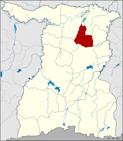
Amphoe Sanom
|
Sanom สนม |
|
|---|---|
| Province: | Surin |
| Surface: | 203.0 km² |
| Residents: | 44,712 (2013) |
| Population density : | 223.0 U / km² |
| ZIP : | 32160 |
| Geocode : | 3208 |
| map | |

|
|
Amphoe Sanom ( Thai : อำเภอ สนม ) is a district ( amphoe - administrative district) in Surin Province . The province of Surin is located in the northeast region of Thailand , the so-called Isan .
geography
Amphoe Sanom borders the following districts (clockwise from the north): Amphoe Rattanaburi , Non Narai , Samrong Thap , Sikhoraphum , Chom Phra and Tha Tum . All Amphoe are in Surin Province.
history
The original name of today's district capital was Ban Nong Sanom ( บ้าน หนอง สนม ), it was a Mueang of Surin. In 1893 it was assigned to Mueang Rattanaburi, today's Amphoe Rattanaburi.
The "Branch Circle" ( King Amphoe ) Sanom was established on July 1, 1971 by separating the five Tambon Sanom, Khaen, Na Nuan, Nong Rakhang and Phon Ko from the Amphoe Rattanaburi. On April 12, 1977 he was officially promoted to Amphoe.
administration
Provincial Administration
The district of Sanom is divided into seven tambon ("subdistricts" or "municipalities"), which are further subdivided into 78 muban ("villages").
| No. | Surname | Thai | Muban | Pop. |
|---|---|---|---|---|
| 1. | Sanom | สนม | 12 | 9,129 |
| 2. | Phon Ko | โพน โก | 12 | 7.164 |
| 3. | Nong Rakhang | หนอง ระฆัง | 8th | 4,455 |
| 4th | Well nuan | นาน วน | 13 | 5,964 |
| 5. | Khaen | แคน | 14th | 8,929 |
| 6th | Hua Ngua | หัว งัว | 8th | 4,272 |
| 7th | Nong I Yo | หนอง อี ย อ | 11 | 4,799 |
Local administration
There are two municipalities with "small town" status ( Thesaban Tambon ) in the district:
- Khaen (Thai: เทศบาล ตำบล แคน ), consisting of the entire Tambon Khaen.
- Sanom (Thai: เทศบาล ตำบล สนม ), consisting of parts of the Tambon Sanom,
There are also six " Tambon Administrative Organizations " ( องค์การ บริหาร ส่วน ตำบล - Tambon Administrative Organizations, TAO):
- Sanom (Thai: องค์การ บริหาร ส่วน ตำบล สนม )
- Phon Ko (Thai: องค์การ บริหาร ส่วน ตำบล โพน โก )
- Nong Rakhang (Thai: องค์การ บริหาร ส่วน ตำบล หนอง ระฆัง )
- Na Nuan (Thai: องค์การ บริหาร ส่วน ตำบล นาน วน )
- Hua Ngua (Thai: องค์การ บริหาร ส่วน ตำบล หัว งัว )
- Nong I Yo (Thai: องค์การ บริหาร ส่วน ตำบล หนอง อี ย อ )
Individual evidence
- ↑ ประกาศ กระทรวง มหาดไทย เรื่อง แบ่ง ท้องที่ อำเภอ รัตนบุรี ตั้ง เป็น กิ่ง อำเภอ สนม จังหวัด สุรินทร์ . In: Royal Gazette . 88, No. 69 ง , June 29, 1971, p. 1864.
- ↑ พระราชกฤษฎีกา ตั้ง อำเภอ ปลายพระยา อำเภอ ห้วยเม็ก อำเภอ ละแม อำเภอ แม่จริม อำเภอ หนองกี่ อำเภอ โคกปีบ อำเภอ เกาะพะงัน อำเภอ สนม อำเภอ โซ่พิสัย อำเภอ โนนสะอาด และ อำเภอ นาจะหลวย พ.ศ. ๒๕๒๐ . In: Royal Gazette . 94, No. 31 ก , April 12, 1977, pp. 326-330.
- ↑ 2013 population statistics ( Thai ) Department of Provincial Administration. Retrieved August 3, 2014.
Web links
Coordinates: 15 ° 12 ' N , 103 ° 46' E
