Phanom Dong Rak district
|
Phanom Dong Rak พนม ดง รัก |
|
|---|---|
| Province: | Surin |
| Surface: | 318.0 km² |
| Residents: | 37,551 (2013) |
| Population density : | 107.4 U / km² |
| ZIP : | 32140 |
| Geocode : | 3214 |
| map | |

|
|
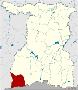
Amphoe Phanom Dong Rak ( Thai : อำเภอ พนม ดง รัก ) is a district ( amphoe - administrative district) in the southwest of Surin Province . The province of Surin is located in the northeast region of Thailand , the so-called Isan .
geography
Phanom Dong Rak District borders the following districts are (from west clockwise) to Amphoe Ban Kruat of Buriram Province , to the Amphoe Prasat and Cape Choeng in Surin province and the province of Oddar Meanchey of Cambodia .
The district is located in the Dongrek Mountains , which separates Thailand from Cambodia. The name of the district means Dongrak Mountains .
history
Amphoe Phanom Dong Rak was initially set up as a “branch circle” ( King Amphoe ) on April 1, 1995 by separating its area from the Amphoe Cape Choeng .
On May 15, 2007 the Thai government decided to raise all 81 King Amphoe to simple amphoe status in order to unify the administration. With the publication in the Royal Gazette "Issue 124 chapter 46" on August 24, 2007 this decision officially entered into force.
Attractions
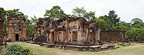
- Prasat Ta Muen - the ruins of a Khmer temple from the 10th century are in the Tambon Ta Miang,
- Prasat Ta Muen Thom - ruins of three Khmer prang with many well-preserved sandstone reliefs,
- Prasat Ta Khwai (Khmer: Prasat Ta Krabey) - right on the border with Cambodia in the middle of the jungle, Prang from around the 11th century.
administration
Provincial Administration
Phanom Dong Rak County is divided into four tambon (“subdistricts” or “parishes”), which are further divided into 55 muban (“villages”).
| No. | Surname | Thai | Muban | Pop. |
|---|---|---|---|---|
| 1. | Bakdai | บัก ได | 20th | 12,299 |
| 2. | Khok sound | โคก กลาง | 11 | 6,876 |
| 3. | Chik Daek | จี ก แดก | 12 | 7,810 |
| 4th | Ta Miang | ตา เมียง | 12 | 10,566 |
Local administration
There are four " Tambon Administrative Organizations " ( องค์การ บริหาร ส่วน ตำบล - Tambon Administrative Organizations, TAO) in the district:
- Bakdai (Thai: องค์การ บริหาร ส่วน ตำบล บัก ได )
- Khok Klang (Thai: องค์การ บริหาร ส่วน ตำบล โคก กลาง )
- Chik Daek (Thai: องค์การ บริหารส่วน ตำบล จี ก แดก )
- Ta Miang (Thai: องค์การ บริหาร ส่วน ตำบล ตา เมียง )
Individual evidence
- ↑ ประกาศ กระทรวง มหาดไทย เรื่อง แบ่ง เขต ท้องที่ อำเภอ กาบเชิง จังหวัด สุรินทร์ ตั้ง เป็น กิ่ง อำเภอ พนม ดง รัก . In: Royal Gazette . 112, No. พิเศษ 9 ง (special), March 22, 1995, p. 55.
- ↑ แถลง ผล การ ประชุม ค รม. ประจำ วัน ที่ 15 พ.ค. 2550 (Thai) , Manager Online.
- ↑ พระราชกฤษฎีกา ตั้ง อำเภอ ฆ้องชัย ... และ อำเภอ เหล่า เสือ โก้ ก พ.ศ. ๒๕๕๐ . In: Royal Gazette . 124, No. 46 ก , August 24, 2007, pp. 14-21.
- ↑ 2013 population statistics ( Thai ) Department of Provincial Administration. Retrieved August 3, 2014.
Web links
Coordinates: 14 ° 27 ' N , 103 ° 18' E


