Amphoe Sangkha
|
Sangkha สังขะ |
|
|---|---|
| Province: | Surin |
| Surface: | 1009.0 km² |
| Residents: | 129,396 (2013) |
| Population density : | 124.4 U / km² |
| ZIP : | 32150 |
| Geocode : | 3210 |
| map | |

|
|
Amphoe Sangkha ( Thai : อำเภอ สังขะ ) is a district ( Amphoe - administrative district) in the south of Surin Province . The province of Surin is located in the northeast region of Thailand , the so-called Isan .
geography
Sangkha district borders the following districts are (from west clockwise) to the Amphoe Kap Choeng , Prasat , Lamduan and Si Narong in the province of Surin, on Amphoe Khukhan the province of Si Sa Ket , at Amphoe Buachet turn in Surin and to the Province Oddar Meancheay of Cambodia .
history
When in 1759 the White Elephant King Ekkathat of Ayutthaya in the forest of khwaeng Mueang Phimai escaped, came forward Chiang Kha ( เชียง ฆะ ), volunteered to capture the head of the village of Ban Khok Atcha and his group to the elephant again. When they were successful, King Ekathat promoted him to Phra Sangkhaburi Si Nakhon Atcha ( พระ สั ง ฆะ บุรี ศรีนคร อั จ จะ ) and in 1763 elevated his village of Ban Khok Atcha to Mueang Sangkha.
In 1778 King Taksin led his troops on a campaign against Vientiane and the Kingdom of Champasak . Mueang Sangkha sent troops in support of the king. After King Taksin won the battles, he promoted the governor of Sangkha to a phraya .
In 1806 Mueang Sangkha was promoted and subordinated to the capital Bangkok. In 1828 Phraya Sankhaburi (Thong Duang) was appointed governor of Mueang Khukhan to replace the previously killed governor. In 1907 the Monthon Isan was divided into four sections (Boriwen) , with Mueang Sangkha being assigned to the Surin section together with Mueang Surin. At that time, Mueang Sangkha was divided into three districts, Sangkha, Si Khonphum and Changkan. In 1912 Monthon Isan was split into Monthon Roi Et and Monthon Ubon Ratchathani, Mueang Surin was assigned to Monthon Ubon Ratchathani, but Mueang Sankha remained in Mueang Surin.
Attractions
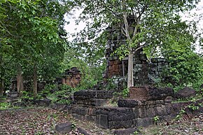
- Prasat Muen Chai - ruins of a Khmer temple in Tambon Krathiam.
- Prasat Phum Pon - ruins of a Khmer temple in the Tambon Cathedral.
- Prasat Yai Ngao - remains of a Khmer prang in the Tambon Sangkha.
administration
Provincial Administration
Sangkha County is divided into twelve tambon ("subdistricts" or "communities"), which are further subdivided into 186 muban ("villages").
| No. | Surname | Thai | Muban | Pop. |
|---|---|---|---|---|
| 1. | Sangkha | สังขะ | 17th | 13,961 |
| 2. | Khon Taek | ขอน แตก | 17th | 9,852 |
| 6th | Dom | ดม | 12 | 8,033 |
| 7th | Phra Kaeo | พระ แก้ว | 18th | 12,848 |
| 8th. | Ban Chan | บ้าน จาร ย์ | 13 | 8,154 |
| 9. | Krathiam | กระเทียม | 21st | 13,273 |
| 10. | Sakat | สะ กาด | 16 | 9,840 |
| 11. | Ta Tum | ตา ตุ ม | 18th | 13,941 |
| 12. | Thap than | ทับ ทัน | 16 | 11,668 |
| 13. | Ta Khong | ตา คง | 14th | 8,777 |
| 15th | Ban chop | บ้าน ช บ | 11 | 10,048 |
| 17th | Thep Raksa | เทพ รักษา | 13 | 9.001 |
Note: The missing numbers (geocodes) refer to tambon , which today belong to Si Narong.
Local administration
There is one municipality with "small town" status ( Thesaban Tambon ) in the district:
- Sangkha (Thai: เทศบาล ตำบล สังขะ ), consisting of parts of the Tambon Sangkha and parts of the Tambon Ban Chop.
There are also twelve " Tambon Administrative Organizations " ( องค์การ บริหาร ส่วน ตำบล - Tambon Administrative Organizations, TAO):
- Sangkha (Thai: องค์การ บริหาร ส่วน ตำบล สังขะ )
- Khon Taek (Thai: องค์การ บริหาร ส่วน ตำบล ขอน แตก )
- Dom (Thai: องค์การ บริหาร ส่วน ตำบล ดม )
- Phra Kaeo (Thai: องค์การ บริหาร ส่วน ตำบล พระ แก้ว )
- Ban Chan (Thai: องค์การ บริหาร ส่วน ตำบล บ้าน จาร ย์ )
- Krathiam (Thai: องค์การ บริหาร ส่วน ตำบล กระเทียม )
- Sakat (Thai: องค์การ บริหาร ส่วน ตำบล สะ กาด )
- Ta Tum (Thai: องค์การ บริหาร ส่วน ตำบล ตา ตุ ม )
- Thap Than (Thai: องค์การ บริหาร ส่วน ตำบล ทับ ทัน )
- Ta Khong (Thai: องค์การ บริหาร ส่วน ตำบล ตา คง )
- Ban Chop (Thai: องค์การ บริหาร ส่วน ตำบล บ้าน ช บ )
- Thep Raksa (Thai: องค์การ บริหาร ส่วน ตำบล เทพ รักษา )
Individual evidence
- ↑ 2013 population statistics ( Thai ) Department of Provincial Administration. Retrieved August 3, 2014.
Web links
Coordinates: 14 ° 38 ' N , 103 ° 51' E


