Amu Darya
|
Amudarja Amu-Darja, Amudaryo u. a. |
||
|
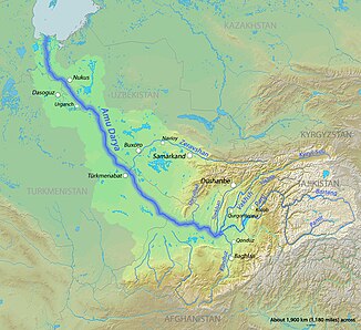
Catchment area of the Amu Darya with tributaries |
||
| Data | ||
| location | Afghanistan , Tajikistan , Uzbekistan , Turkmenistan | |
| River system | Amu Darya | |
| Confluence of |
Pandsch (1125 km long) and Wachsch (524 km) 37 ° 6 ′ 21 ″ N , 68 ° 18 ′ 23 ″ E |
|
| muzzle | formerly the Aral Sea , now seeps into the desert Coordinates: 44 ° 6 ′ 30 ″ N , 59 ° 40 ′ 52 ″ E 44 ° 6 ′ 30 ″ N , 59 ° 40 ′ 52 ″ E
|
|
| length | 1415 km (with the Wachandarja headwaters 2743 km) | |
| Catchment area | 465,000 km² | |
| Outflow at the gauge formerly in the Aral Sea |
MQ |
160 m³ / s |
| Left tributaries | Kunduz | |
| Right tributaries | Kofarnihon , Surxondaryo , Sherobad | |
| Big cities | Termiz , Turkmenabat , Nukus | |
| Medium-sized cities | Kerki | |
| Navigable | The Amu Darya is navigable below Termiz over a length of 1,450 km . | |
|
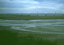
Amu Darya Delta (1994) |
||


The Amudarja or Amudarya (also Amu-Darja ; Persian آمودریا), in ancient times Oxus , is a river in western Central Asia . The length was formerly 1415 km, measured from the union of the two source rivers to the confluence with the Aral Sea . Because of excessive water abstraction, the river now seeps into the desert before it reaches its former estuary.
Spellings and names
In addition to the spelling Amudarja , the spelling Amu-Darja is also used. Influenced by the English spelling Amu Darya , variants with y are also used: Amudarya , Amu-Darya , Amu Darya .
In medieval texts, this river was both Arabic and on Persian Dschayhun (جيحون, DMG Ǧayḥūn ), derived from Gichon , one of the four rivers of the Garden of Eden . It is a contested border river between Iran and Turan in Iranian mythology . The term Āmūdaryā ( also used in today's Persian language )آمودریا) comes from Middle Persian drayak from the old Persian drayah (meaning "sea" or "large watercourse"). In other languages the name is accordingly: Uzbek Amudaryo ; Tajik Омударё Omudarjo , Turkmen Amyderýa , Karakalpak A'miwda'rya , Russian Амударья Amudarja .
The river is also called Ceyhun in Turkish . This name is also used as a male first name (see Ceyhun ).
In ancient times the name of the river was Oxos in Greek and Oxus in Latin . With the Amu Darya, the river name Wehrōd is also identified in Sassanid times, which occurs as one of the two main rivers in the cosmogonic world model of the Middle Persian Bundahishn .
For the Old Persian the term * Waxšu (pronounced's wax shoe ) reconstructs been provided with Vakhan (or Wakhan; see. Wakhan River ) related, the ancient Persian names of the Wakhan region. In Wakhi (Wāchi), the local language, it still bears the name Wux̌ (see also Wachsch ).
River course
The Amu Darya arises on the border of Afghanistan and Tajikistan from the union of its source rivers Pandsch and Wachsch and drains through the lowlands of Turan towards the Aralo-Caspian lowlands . The confluence is in an extensive valley.
Then the upper reaches of the Amu Darya forms the border between Afghanistan and Uzbekistan for a short distance , which is crossed by the Bridge of Friendship at Termiz , and between Afghanistan and Turkmenistan .
South of Kerki , where the border and river separate, the Karakum Canal branches off to the west ( ⊙ ). Shortly afterwards, at Kerki, the Qarshikanal branches off to the east to the Talimardschan reservoir . Continuing to flow in a north-westerly direction, the Amu Darya now represents the border between the Karakum and Kyzylkum deserts and partly between Uzbekistan and Turkmenistan. In its lower reaches it forms the great oasis of Khorezm and finally reaches an inland delta in the Uzbek Karakalpakistan .
Until a few decades ago the Amu Darya flowed into the Aral Sea . Today he no longer reaches the remains of it; Due to the high water extraction and the increased evaporation (caused by the reservoirs) the river in the desert dries up.
River lengths

The Amu Darya was together with its left source river Pandsch to the former confluence with the Aral Sea 2539 km long, together with its longest source river Wachandarja even 2743 kilometers. From the confluence of the source rivers Pandsch (1125 km long) and Wachsch (524 km) to the Aral Sea, the length was 1415 km.
Since the 1970s, the Amu Darya has temporarily dried up before reaching the Aral Sea; it has not reached the Aral Sea since the 1990s. The remaining Aral Sea areas have almost disappeared in the southwest part of the former lake and completely disappeared in the southeast. The attempt that has been made since 2007 to slowly refill the former lake by restricting the withdrawal of water from the tributaries has so far been limited to its northern part.
Water balance and navigability
The catchment area of the Amu Darya is 465,000 km². Between 1911 and 1960, the river at its mouth in the Aral Sea still had an average discharge rate of 1775 m³ / s. A lot of water is currently being withdrawn from the reservoirs built on the Wachsch source river . 12 km³ (approx. 380 m³ / s) flow into the Karakum Canal every year. When crossing the deserts, an estimated 40% is lost, which was an annual mean of 790 m³ / s before 1970. Since the 1970s, irrigation measures have withdrawn an average of more than 1580 m³ / s. As a result, the Amu Darya is now drying up after a length of around 2300 km and thus no longer reaches the Aral Sea, which further promotes its drying out.
The Amu Darya is or was difficult to navigate.
history
Tectonic movements in the Pliocene raised and lowered the region around the Aral Sea. These changed the course of the rivers. The (paleo-) Oxus flowed through the Ungus , Usboi or Schelif-Darja near the Afghan border. But about 150,000 years ago he finally turned to the Aral Sea.
The Oxus gave its name to the Oxus culture that flourished on its banks and the ancient landscape of Transoxania ; on the upper reaches of the river was, among other things, the ancient land of Bactria . The river also gave its name to the Central Asian cobra (Naja oxiana) and the Sogdian fortress Petra Oxiana .
In antiquity, the historian Polybios (2nd century BC) discussed in his historical work (Book X.48) at which point the river can be crossed by the nomads . According to a strange, if not impossible report, the nomads were able to cross the river behind a rock wall at a waterfall. More plausible to him, however, was the second source, which makes a crossing of the river below the cataract over large rock slabs probable, where the Amu Darya / Oxos partly flows underground.
The place of discovery of the so-called Amu Darya or Oxus treasure was on Amu Darya, probably near the ancient city of Tacht-i Sangin south of Shahritus .
places
Termiz, Kerki, Türkmenabat , Beruniy (the old Kath ) and Nukus are located on Amu Darya . The Afghan city of Kunduz is about 70 km from the confluence of the Pandsch and Wachsch rivers . Also Mazar-i-Sharif and Balkh are not further away from the river.
See also
- List of the longest rivers on earth
- List of bridges over the Amu Darya, the Pandsch, the Pamir and the Wachan
literature
- Bertold Spuler : Āmū Daryā. In: Encyclopædia Iranica . 1989
- Bertold Spuler: Āmū Daryā. In: The Encyclopaedia of Islam. New Edition . Volume 1, 1960, pp. 454b-457b
- John Wood : A Journey to the Source of the River Oxus. (1841) New edition, edited by his Son. With an Essay on the Geography of the Valley of the Oxus by Colonel Henry Yule. John Murray, London 1872 ( online at BSB )
Web links
Individual evidence
- ↑ Article Amu Darya in the Great Soviet Encyclopedia (BSE) , 3rd edition 1969–1978 (Russian)
- ↑ Note: without discharges 1,775 m³ / s
- ^ Encyclopædia Britannica Online: Amu Darya
- ↑ Jürgen Ehlers (ed. And trans.): Abū'l-Qāsem Ferdausi: Rostam - The legends from the Šāhnāme . Philipp Reclam jun., Stuttgart 2002, p. 365 f. ( Ğayhūn )
- ↑ https://www. britica.com/topic/Iranian-languages#ref603442
- ^ Amit Kohli, Karen Frenken: Evaporation from artificial lakes and reservoirs. FAO Aquastat Reports, July 2015
- ↑ Encyclopædia Britannica Amu Darya ( page no longer available , search in web archives ) Info: The link was automatically marked as defective. Please check the link according to the instructions and then remove this notice.
- ↑ a b c FAO : FISHERY IN THE LOWER AMU-DARYA UNDER THE IMPACT OF IRRIGATED AGRICULTURE , 1995
- ↑ René Létolle, Monique Mainguet: The Aral Sea. An ecological disaster. Springer Verlag, Berlin, Heidelberg 1996, p. 87
- ↑ René Létolle, Monique Mainguet: The Aral Sea. An ecological disaster. Springer Verlag, Berlin, Heidelberg 1996, p. 22

