
Anantapur (district)
| Anantapur | |
|---|---|

|
|
| State | Andhra Pradesh |
| Administrative headquarters : | Anantapur |
| Area : | 19,130 km² |
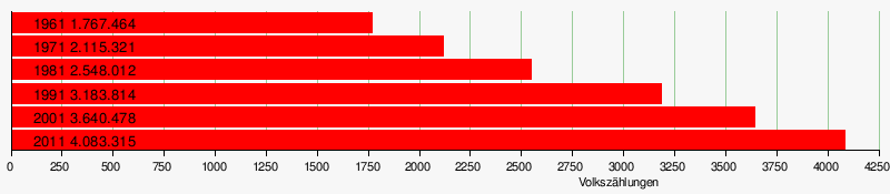
| Residents : | 4,083,315 (2011) |
| Population density : | 213.5 inhabitants / km² |
| Website : | Official website of the district |
Anantapur District (Telugu: అనంతపురం జిల్లా) is one of 13 districts in the Indian state of Andhra Pradesh . The administrative seat is the city of Anantapur .
geography
The district is bordered by the Kurnool district to the north, the YSR district to the east and the Chittoor district to the southeast . Due to its location in the southwest of the state, it borders the state of Karnataka in the south and west .
With its 19,130 km², Anantapur is the largest district in the state of Andhra Pradesh in terms of area. Of the area, 1,970 km² (10.3 percent) are forested. The middle and northern part of the district lies on a high plateau with few rock formations and hills. The south of the district is an area with numerous hills. The most important rivers in the district are the Pennar , Jayamangala , Chitravathi and Vedavathi .
climate
The climate is divided into four seasons. March to May is summer time with great drought and high temperatures. June to September is the time of the southwest monsoon with a lot of rain. October to December is the time of the northeast monsoon. And January and February are winter with cooler temperatures. Anantapur has relatively little rainfall. The long-term average rainfall is 553 mm per year. The southwest monsoon brings 337 mm and the northeast monsoon 156 mm of the annual rainfall. Otherwise there will be little rain. This leads to the drying up of the cultivated areas in the dry season, which lasts from January to May. The amount of rain increases from northwest to southeast. The coldest month is December (average 21.83 ° - daily minimum 16 °, maximum 27 °), the warmest April (average 29.69 ° - minimum 23 °, maximum 36 °).
|
Monthly average temperatures and rainfall for Anantapur
Source: [1]
|
|||||||||||||||||||||||||||||||||||||||||||||||||||||||||||||||||||||||||||||||||||||||||||||||||||||||||||||||||||||||||||||||||||||||||||||||||||||||||||||||||||||
population
The last census in 2011 counted 4,083,315 inhabitants. Of these, 2,064,928 were men (50.6 percent) and 2,018,387 were women. Among the Dalits were 2001 514.698 (14.1 percent), the Adivasi 127,161 (3.5 per cent) people. Of the total number of residents, 1,146,956 people (28.09 percent) lived in urban areas in 2011. Thus, over 70 percent of the population still lived in the country. The majority of the population of Anantapur District speaks Telugu . There are 925 inhabited villages throughout the district.
Population of the district by confession
A clear majority of the population is Hindu. In addition to them, there is a significant number of Muslims of over 10 percent. The Christians are a smaller minority.
| year | Buddhists | Christians | Hindus | Jainas | Muslims | Sikhs | Other | not specified | Total | |||||||||
|---|---|---|---|---|---|---|---|---|---|---|---|---|---|---|---|---|---|---|
| number | % | number | % | number | % | number | % | number | % | number | % | number | % | number | % | number | % | |
| 2001 | 226 | 0.01% | 20,770 | 0.57% | 3,225,156 | 88.59% | 1.110 | 0.03% | 389.201 | 10.69% | 378 | 0.01% | 89 | 0.00% | 3,548 | 0.10% | 3,640,478 | 100.00% |
| Source: 2001 India Census | ||||||||||||||||||
Population development
As everywhere in India, the population in the Anantapur district has been growing rapidly for decades. Although the increase between the last two censuses was just under 12 percent, it is still significant in absolute terms. From 2001 to 2011 the population still increased by over 440,000 people. The following table shows the exact numbers:
Significant places
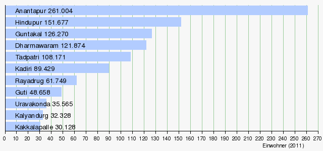
The most populous town in the district is the main town of Anantapur with more than 250,000 residents. Other important cities with over 100,000 inhabitants are Hindupur , Guntakal , Dharmawaram and Tadpatri .
economy

The majority of the population is employed in agriculture. Cultivation is difficult because of the low rainfall. The main crops are peanuts, sunflowers, rice, cotton, corn, chilli, sesame and sugar cane. There is little industry, little natural resources and trade (especially in silk).
history
The district was created in 1882 from parts of the then Bellary district. Area expansions in 1910 (from parts of the then Cuddapah district) and 1956 (from further parts of Bellary district) resulted in its current size. Politically, the district is divided into three control districts Anantapur, Dharmavaram and Penukonda and 63 Mandal divided.
Web links
- official website of Anantapur district
- The Anantapur District on Glorious India
- general information about the district
- Precipitation levels 2006-2010
- District map
- Map of the main streets of the district
- Map of the rivers
- Map of the railway lines
- another map of the district
- First results of the 2011 census
Individual evidence
- ↑ http://censusindia.gov.in/2011census/maps/administrative_maps/INDIA2011.pdf
- ↑ Archive link ( Memento of the original from October 24, 2013 in the Internet Archive ) Info: The archive link was inserted automatically and has not yet been checked. Please check the original and archive link according to the instructions and then remove this notice. Forest Report, page 3
- ↑ Climate-average rainfall ( memento of the original from May 2, 2012 in the Internet Archive ) Info: The archive link was inserted automatically and has not yet been checked. Please check the original and archive link according to the instructions and then remove this notice. (PDF; 1.4 MB)
- ↑ Climate in Anantapur
- ↑ Data on the climate
- ↑ Census of India 2001 (PDF; 54 kB)
- ↑ AP Online: District - Anantapur ( Memento of the original from March 26, 2015 in the Internet Archive ) Info: The archive link was automatically inserted and not yet checked. Please check the original and archive link according to the instructions and then remove this notice. .

Anantapur | Chittoor | East Godavari | Guntur | Krishna | Kurnool | Prakasam | Srikakulam | Sri Potti Sriramulu Nellore | Visakhapatnam | Vizianagaram | West Godavari | YSR
Coordinates: 14 ° 42 ' N , 77 ° 36' E