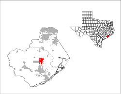
Angleton
| Angleton | |
|---|---|
|
Location of Angleton in Texas
|
|
| Basic data | |
| Foundation : | November 12, 1912 |
| State : | United States |
| State : | Texas |
| County : | Brazoria County |
| Coordinates : | 29 ° 10 ′ N , 95 ° 26 ′ W |
| Time zone : | Central ( UTC − 6 / −5 ) |
| Residents : | 18,130 (as of: 2000) |
| Population density : | 664.1 inhabitants per km 2 |
| Area : | 27.4 km 2 (approx. 11 mi 2 ) of which 27.3 km 2 (approx. 11 mi 2 ) are land |
| Height : | 6 m |
| Postal code : | 77515 |
| Area code : | +1 979 |
| FIPS : | 48-03264 |
| GNIS ID : | 1351127 |
| Website : | www.angleton.tx.us |
| Mayor : | J. Patrick Henry |
Angleton is a city and seat of the county seat of Brazoria County in the US state of Texas in the United States .
geography
Angleton is located in southeast Texas, about 45 km south of Houston , 28 km from the Gulf of Mexico and covers an area of 27.4 km², of which 0.15 km² is water.
Demographics
| growth of population | |||
|---|---|---|---|
| Census | Residents | ± in% | |
| 1920 | 1043 | - | |
| 1930 | 1229 | 17.8% | |
| 1940 | 1763 | 43.4% | |
| 1950 | 3399 | 92.8% | |
| 1960 | 7312 | 115.1% | |
| 1970 | 9770 | 33.6% | |
| 1980 | 13,929 | 42.6% | |
| 1990 | 17,140 | 23.1% | |
| 2000 | 18,130 | 5.8% | |
| 2010 | 18,862 | 4% | |
| 1930-2000 2010 | |||
According to the 2000 census, there are 4,894 families in the city. The population density is 663 / km². 75.2% of the population see themselves as white, 11.4% as black, 0.5% of Indian and 1.1% of Asian descent. 9.6% describe themselves as belonging to another race. As Hispancis or Latinos is 23% see.
The median household income is $ 42,184 and the median family income is $ 50,019. The mean size of a household is 2.75, the mean family size 3.19 people. Of the population under the age of 18, 14.4% live below the poverty line , of the population over 65 it is 13.8%.
history
Angleton was founded in 1890 with the development of the area by railroad lines. The city was named after the wife of a managing director of the Velasco Terminal Railway . On November 12, 1912, the place received city rights.
economy
In particular, Angleton is a trading center for agricultural products. With the growth of the chemical industry in Freeport to the south in the 1940s, Angleton also gained importance as a banking and logistics center for petroleum and chemical products.
See also
Individual evidence
- ↑ Information from the National Association of Counties ( Memento of the original from January 24, 2012 in the Internet Archive ) Info: The archive link was inserted automatically and has not yet been checked. Please check the original and archive link according to the instructions and then remove this notice. . Retrieved October 10, 2012
- ↑ Texas Almanac (PDF; 1.2 MB). Retrieved October 4, 2012
- ↑ US Census data for 2010 . Retrieved October 12, 2012
Web links
- Angleton in the Handbook of Texas (Engl.)
- Statistics Angleton city-data (Engl.)
